 People's Democratic Republic of Algeria Google Maps and Facts
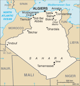
Welcome to the Google Maps of Algeria (DZ) and the comprehensive location list for this country. World Route Planner, together with its detailed Algeria page, turns Google Maps Sightseeing into a meaningful experience! Our extensive destination gazetteer, coupled with Driving Directions to Algeria, allows you to explore Algeria through detailed satellite imagery and street views—fast, free, and easier than ever before.
Browse through the list of administrative regions in Algeria, navigate through these regions to find a place of interest, and book your hotel with the Best Price Guarantee! Your journey through Algeria via Google Satellite Map Sightseeing and Street View starts here.
Algeria Google Maps
To activate Street View on any city of Algeria, drag above the Zoom feature the yellow little man in the map.
Facts about Algeria
| Administrative divisions: | 48 provinces (wilayat , singular - wilaya); Adrar , Ain Defla , Ain Temouchent , Alger , Annaba , Batna , Bechar , Bejaia , Biskra , Blida , Bordj Bou Arreridj , Bouira , Boumerdes , Chlef , Constantine , Djelfa , El Bayadh , El Oued , El Tarf , Ghardaia , Guelma , Illizi , Jijel , Khenchela , Laghouat , Mascara , Medea , Mila , Mostaganem , M'Sila , Naama , Oran , Ouargla , Oum el Bouaghi , Relizane , Saida , Setif , Sidi Bel Abbes , Skikda , Souk Ahras , Tamanghasset , Tebessa , Tiaret , Tindouf , Tipaza , Tissemsilt , Tizi Ouzou , Tlemcen |
| Area: | total: 2 ,381 ,740 sq km land: 2 ,381 ,740 sq km water: 0 sq km |
| Background: | After more than a century of rule by France , Algerians fought through much of the 1950s to achieve independence in 1962. Algeria's primary political party , the National Liberation Front (FLN) , has dominated politics ever since. Many Algerians in the subsequent generation were not satisfied , however , and moved to counter the FLN's centrality in Algerian politics. The surprising first round success of the Islamic Salvation Front (FIS) in the December 1991 balloting spurred the Algerian army to intervene and postpone the second round of elections to prevent what the secular elite feared would be an extremist-led government from assuming power. The army began a crackdown on the FIS that spurred FIS supporters to begin attacking government targets. The government later allowed elections featuring pro-government and moderate religious-based parties , but did not appease the activists who progressively widened their attacks. The fighting escalated into an insurgency , which saw intense fighting between 1992-98 and which resulted in over 100 ,000 deaths - many attributed to indiscriminate massacres of villagers by extremists. The government gained the upper hand by the late-1990s and FIS's armed wing , the Islamic Salvation Army , disbanded in January 2000. However , small numbers of armed militants persist in confronting government forces and conducting ambushes and occasional attacks on villages. The army placed Abdelaziz BOUTEFLIKA in the presidency in 1999 in a fraudulent election but claimed neutrality in his 2004 landslide reelection victory. Longstanding problems continue to face BOUTEFLIKA in his second term , including the ethnic minority Berbers' ongoing autonomy campaign , large-scale unemployment , a shortage of housing , unreliable electrical and water supplies , government inefficiencies and corruption , and the continuing activities of extremist militants. The 2006 merger of the Salafist Group for Preaching and Combat (GSPC) with al-Qaida (followed by a name change to al-Qaida in the Lands of the Islamic Maghreb) signaled an increase in bombings , including high-profile , mass-casualty suicide attacks targeted against the Algerian government and Western interests. Algeria must also diversify its petroleum-based economy , which has yielded a large cash reserve but which has not been used to redress Algeria's many social and infrastructure problems. |
| Flag description: | two equal vertical bands of green (hoist side) and white; a red , five-pointed star within a red crescent centered over the two-color boundary note: the crescent , star , and color green are traditional symbols of Islam (the state religion) |
| Capital: | name: Algiers geographic coordinates: 36 45 N , 3 03 E time difference: UTC+1 (6 hours ahead of Washington , DC during Standard Time) |
| Climate: | arid to semiarid; mild , wet winters with hot , dry summers along coast; drier with cold winters and hot summers on high plateau; sirocco is a hot , dust/sand-laden wind especially common in summer |
| Currency code: | Algerian dinar (DZD) |
| Ethnic groups: | Arab-Berber 99% , European less than 1% note: almost all Algerians are Berber in origin , not Arab; the minority who identify themselves as Berber live mostly in the mountainous region of Kabylie east of Algiers; the Berbers are also Muslim but identify with their Berber rather than Arab cultural heritage; Berbers have long agitated , sometimes violently , for autonomy; the government is unlikely to grant autonomy but has offered to begin sponsoring teaching Berber language in schools |
| Geographic coordinates: | 28 00 N , 3 00 E |
| Geography note: | second-largest country in Africa (after Sudan) |
| Government type: | republic |
| Imports partners: | France 19.1% , China 9.2% , Italy 8.7% , Spain 6.1% , US 5.6% , Germany 5.5% , Turkey 4.2% (2007) |
| Internet country code: | .dz |
| Land boundaries: | 998 km |
| Neighbouring countries: | total: 6 ,343 km border countries: Libya 982 km , Mali 1 ,376 km , Mauritania 463 km , Morocco 1 ,559 km , Niger 956 km , Tunisia 965 km , Western Sahara 42 km |
| Languages: | Arabic (official) , French , Berber dialects |
| Location: | Northern Africa , bordering the Mediterranean Sea , between Morocco and Tunisia |
| Map references: | Africa |
| National holiday: | Revolution Day , 1 November (1954) |
| Nationality: | noun: Algerian(s) adjective: Algerian |
| Natural hazards: | mountainous areas subject to severe earthquakes; mudslides and floods in rainy season |
| Population: | 33 ,769 ,668 (July 2008 est.) |
| Religions: | Sunni Muslim (state religion) 99% , Christian and Jewish 1% |
| Terrain: | mostly high plateau and desert; some mountains; narrow , discontinuous coastal plain |
| Unemployment rate: | 11.8% (2007 est.) |
Capital of People's Democratic Republic of Algeria
Alger (click to view Alger map)
Places in Algeria
Browse the most comprehensive and up-to-date online directory of administrative regions and Street Views in Algeria. Our listings are organized alphabetically, starting from level 1 regions and progressing through to level 2 and eventually level 3 regions, ensuring you can easily navigate and find specific areas of interest.
Aïn Defla Province (186 google map locations)
Aïn Témouchent Province (75 google map locations)
Algiers Province (75 google map locations)
Annaba Province (178 google map locations)
Batna Province (257 google map locations)
Béchar Province (51 google map locations)
Béjaïa Province (267 google map locations)
Biskra Province (94 google map locations)
Blida Province (84 google map locations)
Bordj Bou Arréridj Province (153 google map locations)
Bouira Province (132 google map locations)
Boumerdès Province (175 google map locations)
Chlef Province (444 google map locations)
Constantine Province (160 google map locations)
Djelfa Province (52 google map locations)
El Bayadh Province (28 google map locations)
El Oued Province (58 google map locations)
El Tarf Province (44 google map locations)
Ghardaïa Province (12 google map locations)
Guelma Province (53 google map locations)
Illizi Province (16 google map locations)
Jijel Province (136 google map locations)
Khenchela Province (59 google map locations)
M'Sila Province (224 google map locations)
Mascara Province (359 google map locations)
Medea Province (282 google map locations)
Mila Province (73 google map locations)
Mostaganem Province (208 google map locations)
Naama Province (19 google map locations)
Oran Province (141 google map locations)
Ouargla Province (55 google map locations)
Oum el-Bouaghi Province (97 google map locations)
Relizane Province (450 google map locations)
Saida Province (38 google map locations)
Sétif Province (308 google map locations)
Side Bel Abbes Province (78 google map locations)
Skikda Province (152 google map locations)
Souk Ahras Province (41 google map locations)
Tamanghasset Province (30 google map locations)
Tébessa Province (43 google map locations)
Tiaret Province (201 google map locations)
Tindouf Province (2 google map locations)
Tipaza Province (205 google map locations)
Tissemsilt Province (43 google map locations)
Tizi Ouzou Province (359 google map locations)
Tlemcen Province (186 google map locations)
Random cities in Algeria
Alger, the capital city of Algeria.Zérizer
Tirhilt-n-Aït Ziane
El Rhoraf
El Kala
Mechta Zeraïa
Bir Hamoudi
Afras
Aranim
Mechta Ameur Ben Amier
Bou Ballouta
Guertoufa
Ibahial
'Aïn Ihanou
Ouled Haoua
Tagounit Irhil
Dar M'ta Ouled Rhenane
Baltache
Inndouz
Mechta Bou Ari
Link to Algeria Google Maps page
The map of Algeria has already attracted 9537 views. If you wish to embed our comprehensive Algeria map on your site, we offer an easy solution. This map includes free access to Google Maps, gazetteer search, detailed country and city maps, Street View, and essential facts, all ready to enhance your website. To use it, simply copy and paste the provided HTML code into your webpage's source code. We appreciate every link back to our Maps and Driving Directions. Thank you for your support!
| Text link to: Algeria map and facts page |
This Algeria map is intended solely for informational purposes. No representations or warranties are made concerning its accuracy or reliability. Users assume all risks associated with the use of Google Maps and Google Driving Directions. World Route Planner is not liable for any losses or delays that may occur from using this free Algeria map.