 Burkina Faso Google Maps and Facts
Welcome to the Google Maps of Burkina Faso (BF) and the comprehensive location list for this country. World Route Planner, together with its detailed Burkina Faso page, turns Google Maps Sightseeing into a meaningful experience! Our extensive destination gazetteer, coupled with Driving Directions to Burkina Faso, allows you to explore Burkina Faso through detailed satellite imagery and street views—fast, free, and easier than ever before.
Browse through the list of administrative regions in Burkina Faso, navigate through these regions to find a place of interest, and book your hotel with the Best Price Guarantee! Your journey through Burkina Faso via Google Satellite Map Sightseeing and Street View starts here.
Burkina Faso Google Maps
To activate Street View on any city of Burkina Faso, drag above the Zoom feature the yellow little man in the map.
Facts about Burkina Faso
| Administrative divisions: | 45 provinces; Bale , Bam , Banwa , Bazega , Bougouriba , Boulgou , Boulkiemde , Comoe , Ganzourgou , Gnagna , Gourma , Houet , Ioba , Kadiogo , Kenedougou , Komondjari , Kompienga , Kossi , Koulpelogo , Kouritenga , Kourweogo , Leraba , Loroum , Mouhoun , Nahouri , Namentenga , Nayala , Noumbiel , Oubritenga , Oudalan , Passore , Poni , Sanguie , Sanmatenga , Seno , Sissili , Soum , Sourou , Tapoa , Tuy , Yagha , Yatenga , Ziro , Zondoma , Zoundweogo |
| Area: | total: 274 ,200 sq km land: 273 ,800 sq km water: 400 sq km |
| Background: | Burkina Faso (formerly Upper Volta) achieved independence from France in 1960. Repeated military coups during the 1970s and 1980s were followed by multiparty elections in the early 1990s. Current President Blaise COMPAORE came to power in a 1987 military coup and has won every election since then. Burkina Faso's high population density and limited natural resources result in poor economic prospects for the majority of its citizens. Recent unrest in Cote d'Ivoire and northern Ghana has hindered the ability of several hundred thousand seasonal Burkinabe farm workers to find employment in neighboring countries. |
| Flag description: | two equal horizontal bands of red (top) and green with a yellow five-pointed star in the center note: uses the popular pan-African colors of Ethiopia |
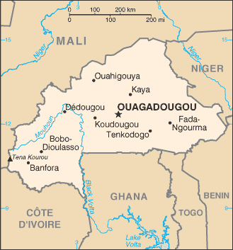
| Capital: | name: Ouagadougou geographic coordinates: 12 22 N , 1 31 W time difference: UTC 0 (5 hours ahead of Washington , DC during Standard Time) |
| Climate: | tropical; warm , dry winters; hot , wet summers |
| Currency code: | Communaute Financiere Africaine franc (XOF); note - responsible authority is the Central Bank of the West African States |
| Ethnic groups: | Mossi over 40% , other approximately 60% (includes Gurunsi , Senufo , Lobi , Bobo , Mande , and Fulani) |
| Geographic coordinates: | 13 00 N , 2 00 W |
| Geography note: | landlocked savanna cut by the three principal rivers of the Black , Red , and White Voltas |
| Government type: | parliamentary republic |
| Imports partners: | Cote d'Ivoire 25.6% , France 20.5% , Togo 7.1% (2007) |
| Internet country code: | .bf |
| Land boundaries: | 0 km (landlocked) |
| Neighbouring countries: | total: 3 ,193 km border countries: Benin 306 km , Cote d'Ivoire 584 km , Ghana 549 km , Mali 1 ,000 km , Niger 628 km , Togo 126 km |
| Languages: | French (official) , native African languages belonging to Sudanic family spoken by 90% of the population |
| Location: | Western Africa , north of Ghana |
| Map references: | Africa |
| National holiday: | Republic Day , 11 December (1958) |
| Nationality: | noun: Burkinabe (singular and plural) adjective: Burkinabe |
| Natural hazards: | recurring droughts |
| Population: | 15 ,264 ,735 note: estimates for this country explicitly take into account the effects of excess mortality due to AIDS; this can result in lower life expectancy , higher infant mortality , higher death rates , lower population growth rates , and changes in the distribution of population by age and sex than would otherwise be expected (July 2008 est.) |
| Religions: | Muslim 50% , indigenous beliefs 40% , Christian (mainly Roman Catholic) 10% |
| Terrain: | mostly flat to dissected , undulating plains; hills in west and southeast |
| Unemployment rate: | 77% (2004) |
Capital of Burkina Faso
Ouagadougou (click to view Ouagadougou map)
Places in Burkina Faso
Browse the most comprehensive and up-to-date online directory of administrative regions and Street Views in Burkina Faso. Our listings are organized alphabetically, starting from level 1 regions and progressing through to level 2 and eventually level 3 regions, ensuring you can easily navigate and find specific areas of interest.
Boulgou Province (400 google map locations)
Boulkiemdé Province (583 google map locations)
Comoé Province (265 google map locations)
Gnagna Province (116 google map locations)
Gourma Province (297 google map locations)
Houet Province (195 google map locations)
Ioba Province (251 google map locations)
Kénédougou Province (246 google map locations)
Komondjari Province (345 google map locations)
Koulpélogo Province (216 google map locations)
Kourwéogo Province (243 google map locations)
Léraba Province (280 google map locations)
Mouhoun Province (302 google map locations)
Nahouri Province (331 google map locations)
Namentenga Province (258 google map locations)
Nayala Province (248 google map locations)
Oudalan Province (315 google map locations)
Poni Province (694 google map locations)
Province de la Komondjari (1 google map locations)
Province de la Kompienga (1 google map locations)
Province de la Léraba (1 google map locations)
Province des Balé (1 google map locations)
Province du Ioba (1 google map locations)
Province du Koulpélogo (1 google map locations)
Province du Kourwéogo (1 google map locations)
Province du Loroum (1 google map locations)
Province du Nayala (1 google map locations)
Province du Noumbiel (1 google map locations)
Province du Tuy (1 google map locations)
Province du Yagha (1 google map locations)
Province du Ziro (1 google map locations)
Province du Zondoma (1 google map locations)
Sanguié Province (254 google map locations)
Sanmatenga Province (258 google map locations)
Séno Province (55 google map locations)
Sissili Province (166 google map locations)
Soum Province (449 google map locations)
Tuy Province (170 google map locations)
Yagha Province (197 google map locations)
Yatenga Province (282 google map locations)
Ziro Province (325 google map locations)
Zondoma Province (540 google map locations)
Zoundwéogo Province (61 google map locations)
Random cities in Burkina Faso
Ouagadougou, the capital city of Burkina Faso.Bilanbar
Ouavoussé
Trakoulatenga
Tanhio
Dakoula
Ayoubakolon
Naguéléma
Tanga
Léfourba
Kona
Balonza
Kalsagado
Popoï
Baniaba
Kotina
Yankasso
Doutonblé
Zakuy
Siguinvoussé
Link to Burkina Faso Google Maps page
The map of Burkina Faso has already attracted 4077 views. If you wish to embed our comprehensive Burkina Faso map on your site, we offer an easy solution. This map includes free access to Google Maps, gazetteer search, detailed country and city maps, Street View, and essential facts, all ready to enhance your website. To use it, simply copy and paste the provided HTML code into your webpage's source code. We appreciate every link back to our Maps and Driving Directions. Thank you for your support!
| Text link to: Burkina Faso map and facts page |
This Burkina Faso map is intended solely for informational purposes. No representations or warranties are made concerning its accuracy or reliability. Users assume all risks associated with the use of Google Maps and Google Driving Directions. World Route Planner is not liable for any losses or delays that may occur from using this free Burkina Faso map.