 Republic of Chad Google Maps and facts
Welcome to Google Maps of Chad (TD) and locations list of this country. World Route Planner and its detailed Chad page is the place where Google Maps Sightseeing make sense! With comprehensive destination gazetteer, Driving Directions to Chad, World Route Planner enables you to explore Chad through detailed Satellite Imagery and Street View - fast, free and easy as never before. Browse the list of administrative regions below of Chad, follow the navigation through administrative regions to find a place you are interested in and Book your hotel with Best Price Guarantee! Your Chad Google Satellite Map Sightseeing and Street View start here.
To activate Street View on any city of Chad, drag above the Zoom feature the yellow little man in the map.
Facts about Chad
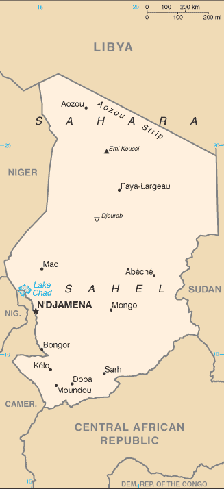
| Administrative divisions: | 18 regions (regions , singular - region); Batha , Borkou-Ennedi-Tibesti , Chari-Baguirmi , Guera , Hadjer-Lamis , Kanem , Lac , Logone Occidental , Logone Oriental , Mandoul , Mayo-Kebbi Est , Mayo-Kebbi Ouest , Moyen-Chari , Ouaddai , Salamat , Tandjile , Ville de N'Djamena , Wadi Fira |
| Area: | total: 1.284 million sq km land: 1 ,259 ,200 sq km water: 24 ,800 sq km |
| Background: | Chad , part of France's African holdings until 1960 , endured three decades of civil warfare as well as invasions by Libya before a semblance of peace was finally restored in 1990. The government eventually drafted a democratic constitution , and held flawed presidential elections in 1996 and 2001. In 1998 , a rebellion broke out in northern Chad , which has sporadically flared up despite several peace agreements between the government and the rebels. In 2005 , new rebel groups emerged in western Sudan and made probing attacks into eastern Chad , despite signing peace agreements in December 2006 and October 2007. Power remains in the hands of an ethnic minority. In June 2005 , President Idriss DEBY held a referendum successfully removing constitutional term limits and won another controversial election in 2006. Sporadic rebel campaigns continued throughout 2006 and 2007 , and the capital experienced a significant rebel threat in early 2008. |
| Flag description: | three equal vertical bands of blue (hoist side) , yellow , and red note: similar to the flag of Romania; also similar to the flags of Andorra and Moldova , both of which have a national coat of arms centered in the yellow band; design was based on the flag of France |
| Capital: | name: N'Djamena geographic coordinates: 12 06 N , 15 02 E time difference: UTC+1 (6 hours ahead of Washington , DC during Standard Time) |
| Climate: | tropical in south , desert in north |
| Currency code: | Communaute Financiere Africaine franc (XAF); note - responsible authority is the Bank of the Central African States |
| Ethnic groups: | Sara 27.7% , Arab 12.3% , Mayo-Kebbi 11.5% , Kanem-Bornou 9% , Ouaddai 8.7% , Hadjarai 6.7% , Tandjile 6.5% , Gorane 6.3% , Fitri-Batha 4.7% , other 6.4% , unknown 0.3% (1993 census) |
| Geographic coordinates: | 15 00 N , 19 00 E |
| Geography note: | landlocked; Lake Chad is the most significant water body in the Sahel |
| Government type: | republic |
| Imports partners: | France 19.7% , Cameroon 15.6% , US 10.6% , China 9.7% , Germany 7.3% , Saudi Arabia 4.3% (2007) |
| Internet country code: | .td |
| Land boundaries: | 0 km (landlocked) |
| Neighbouring countries: | total: 5 ,968 km border countries: Cameroon 1 ,094 km , Central African Republic 1 ,197 km , Libya 1 ,055 km , Niger 1 ,175 km , Nigeria 87 km , Sudan 1 ,360 km |
| Languages: | French (official) , Arabic (official) , Sara (in south) , more than 120 different languages and dialects |
| Location: | Central Africa , south of Libya |
| Map references: | Africa |
| National holiday: | Independence Day , 11 August (1960) |
| Nationality: | noun: Chadian(s) adjective: Chadian |
| Natural hazards: | hot , dry , dusty harmattan winds occur in north; periodic droughts; locust plagues |
| Population: | 10 ,111 ,337 (July 2008 est.) |
| Religions: | Muslim 53.1% , Catholic 20.1% , Protestant 14.2% , animist 7.3% , other 0.5% , unknown 1.7% , atheist 3.1% (1993 census) |
| Terrain: | broad , arid plains in center , desert in north , mountains in northwest , lowlands in south |
| Unemployment rate: | NA% |
Capital of Republic of Chad
N'Djamena (click to view N'Djamena map)
Places in Chad
Browse the most comprehensive and up-to-date online directory of administrative regions and Street views in Chad. Regions are sorted in alphabetical order from level 1 to level 2 and eventually up to level 3 regions.
Préfecture du Biltine (377 google map locations)
Préfecture du Borkou-Ennedi-Tibesti (56 google map locations)
Préfecture du Chari-Baguirmi (1024 google map locations)
Préfecture du Guéra (477 google map locations)
Préfecture du Kanem (302 google map locations)
Préfecture du Lac (327 google map locations)
Préfecture du Logone Oriental (379 google map locations)
Préfecture du Mayo-Kébbi (713 google map locations)
Préfecture du Moyen-Chari (801 google map locations)
Préfecture du Ouaddaï (1197 google map locations)
Préfecture du Salamat (270 google map locations)
Préfecture du Tandjilé (305 google map locations)
Random cities in Chad
N'Djamena, the capital city of Chad.Kouloula
Am Bitin Tiné
Mélom
Mbala
Doumbané
Marofi
El Biher
Betoum
Kouloulirom
Kidjibour
Matara
Ngara
Mourou
Kossigné
Addehera
Dankala
Batalay
Abd er Rasoul
Niagar Niagar
This Chad map is for informational use only. No representation is made or warranty given as to its content. User assumes all risk of using Google Maps and Google Driving Directions. World Route Planner assumes no responsibility for any loss or delay resulting from such use of free Chad map.
Link to Chad Google Maps page
This map of Chad has been viewed 4162 times until now. In case you would like, there is a very easy way how to link to our Chad map - including free Google Maps, gazetteer search, country, city maps, Street View and facts -, ready to use on your website. Please, simply copy & paste the provided HTML code into your page source code: Thank you for all links to our Maps and Driving Directions!
| Text link to: Chad map |