 Republic of the Congo Google Maps and Facts
Map of Congo, Republic of the ⇣ | Google Maps of Congo, Republic of the ⇣ | All Places in Congo, Republic of the ⇣
Welcome to the Google Maps of Congo, Republic of the (CG) and the comprehensive location list for this country. World Route Planner, together with its detailed Congo, Republic of the page, turns Google Maps Sightseeing into a meaningful experience! Our extensive destination gazetteer, coupled with Driving Directions to Congo, Republic of the, allows you to explore Congo, Republic of the through detailed satellite imagery and street views—fast, free, and easier than ever before.
Browse through the list of administrative regions in Congo, Republic of the, navigate through these regions to find a place of interest, and book your hotel with the Best Price Guarantee! Your journey through Congo, Republic of the via Google Satellite Map Sightseeing and Street View starts here.
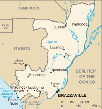
Congo, Republic of the Google Maps
To activate Street View on any city of Congo, Republic of the, drag above the Zoom feature the yellow little man in the map.
Facts about Congo, Republic of the
| Administrative divisions: | 10 regions (regions , singular - region) and 1 commune*; Bouenza , Brazzaville* , Cuvette , Cuvette-Ouest , Kouilou , Lekoumou , Likouala , Niari , Plateaux , Pool , Sangha |
| Area: | total: 342 ,000 sq km land: 341 ,500 sq km water: 500 sq km |
| Background: | Upon independence in 1960 , the former French region of Middle Congo became the Republic of the Congo. A quarter century of experimentation with Marxism was abandoned in 1990 and a democratically elected government took office in 1992. A brief civil war in 1997 restored former Marxist President Denis SASSOU-NGUESSO , and ushered in a period of ethnic and political unrest. Southern-based rebel groups agreed to a final peace accord in March 2003 , but the calm is tenuous and refugees continue to present a humanitarian crisis. The Republic of Congo was once one of Africa's largest petroleum producers , but with declining production it will need new offshore oil finds to sustain its oil earnings over the long term. |
| Flag description: | divided diagonally from the lower hoist side by a yellow band; the upper triangle (hoist side) is green and the lower triangle is red note: uses the popular pan-African colors of Ethiopia |
| Capital: | name: Brazzaville geographic coordinates: 4 15 S , 15 17 E time difference: UTC+1 (six hours ahead of Washington , DC during Standard Time) |
| Climate: | tropical; rainy season (March to June); dry season (June to October); persistent high temperatures and humidity; particularly enervating climate astride the Equator |
| Currency code: | Communaute Financiere Africaine franc (XAF); note - responsible authority is the Bank of the Central African States |
| Ethnic groups: | Kongo 48% , Sangha 20% , M'Bochi 12% , Teke 17% , Europeans and other 3% |
| Geographic coordinates: | 1 00 S , 15 00 E |
| Geography note: | about 70% of the population lives in Brazzaville , Pointe-Noire , or along the railroad between them |
| Government type: | republic |
| Imports partners: | France 21.5% , China 14.9% , Italy 12.2% , India 5.6% , US 5% , Belgium 4.5% (2007) |
| Internet country code: | .cg |
| Land boundaries: | 169 km |
| Neighbouring countries: | total: 5 ,504 km border countries: Angola 201 km , Cameroon 523 km , Central African Republic 467 km , Democratic Republic of the Congo 2 ,410 km , Gabon 1 ,903 km |
| Languages: | French (official) , Lingala and Monokutuba (lingua franca trade languages) , many local languages and dialects (of which Kikongo is the most widespread) |
| Location: | Western Africa , bordering the South Atlantic Ocean , between Angola and Gabon |
| Map references: | Africa |
| National holiday: | Independence Day , 15 August (1960) |
| Nationality: | noun: Congolese (singular and plural) adjective: Congolese or Congo |
| Natural hazards: | seasonal flooding |
| Population: | 3 ,903 ,318 note: estimates for this country explicitly take into account the effects of excess mortality due to AIDS; this can result in lower life expectancy , higher infant mortality , higher death rates , lower population growth rates , and changes in the distribution of population by age and sex than would otherwise be expected (July 2008 est.) |
| Religions: | Christian 50% , animist 48% , Muslim 2% |
| Terrain: | coastal plain , southern basin , central plateau , northern basin |
| Unemployment rate: | NA% |
Capital of Republic of the Congo
Brazzaville (click to view Brazzaville map)
Places in Congo, Republic of the
Browse the most comprehensive and up-to-date online directory of administrative regions and Street Views in Congo, Republic of the. Our listings are organized alphabetically, starting from level 1 regions and progressing through to level 2 and eventually level 3 regions, ensuring you can easily navigate and find specific areas of interest.
Abalaka city Google map
Abana city Google map
Abéla city Google map
Abolo city Google map
Abvoura city Google map
Adinga city Google map
Adzié city Google map
Adzié II city Google map
Aéko city Google map
Akalamba city Google map
Akana I city Google map
Akana II city Google map
Akaya city Google map
Akou city Google map
Akoua city Google map
Alémé city Google map
Ambimi city Google map
Anbéla city Google map
Ancien Bibaya city Google map
Ancien Ngonbé city Google map
Andeko city Google map
Andjoko city Google map
Andjoko II city Google map
Andouma city Google map
Angalé city Google map
Angomo city Google map
Angomon city Google map
Angomon II city Google map
Atali city Google map
Ayandza city Google map
Bandza Moké city Google map
Baya city Google map
Benza city Google map
Bibaya city Google map
Bilinga city Google map
Bioko city Google map
Bokania city Google map
Bondzalé city Google map
Botanga city Google map
Boua city Google map
Bouniangoulou city Google map
Commune of Brazzaville (1 google map locations)
Djoko city Google map
Djongo city Google map
Djouama city Google map
Doubandjo city Google map
Douka city Google map
Doulou city Google map
Ebana city Google map
Ebili city Google map
Ebongui city Google map
Ebou city Google map
Eboundji city Google map
Edigui city Google map
Ediki city Google map
Eka city Google map
Ekagna city Google map
Ekami city Google map
Ekéri city Google map
Ekièmbé city Google map
Ekogo city Google map
Ekombébana city Google map
Ekouélé city Google map
Ekoumoukou city Google map
Ekouya city Google map
Endagui city Google map
Endigui city Google map
Endiké city Google map
Endouo city Google map
Engana city Google map
Enkéya city Google map
Enkosso city Google map
Epété city Google map
Essi city Google map
Essoura city Google map
Étoka city Google map
Etoumbi city Google map
Etoumi city Google map
Eyongo city Google map
Foura city Google map
Ibonga city Google map
Ihoura city Google map
Ikamou city Google map
Ilokoyo city Google map
Indzomoko city Google map
Issengué city Google map
Issongo city Google map
Kami city Google map
Kébouya city Google map
Kékélé city Google map
Kempaka city Google map
Kénabouma city Google map
Kenvouani city Google map
Kenvouomo city Google map
Képouya city Google map
Kimbonga city Google map
Komba city Google map
Kongho city Google map
Kongotali city Google map
Korogo I city Google map
Korogo II city Google map
Kotomitef city Google map
Koufoua Moukoulou city Google map
Kouméya city Google map
Kouya city Google map
Kouyou city Google map
Lébala city Google map
Lecouna city Google map
Lekondji city Google map
Lékori city Google map
lengé city Google map
Letoumbou city Google map
Liboko city Google map
Libonga city Google map
Libounga city Google map
Lobomo city Google map
Loukouala city Google map
Louomi city Google map
Loutembo city Google map
Malié city Google map
Mamwana city Google map
Matoko city Google map
Mbama city Google map
Mbandza city Google map
Mbèndé city Google map
Mboli-Ebaka city Google map
Mboli-Yandza city Google map
Mboma city Google map
Mbomo city Google map
Mbou city Google map
Mbouli city Google map
Mboumou city Google map
Mitoula city Google map
Moangui city Google map
Mobembo city Google map
Modzaka city Google map
Mohali city Google map
Molembé Kombé city Google map
Moshué city Google map
Mouangui city Google map
Mounkouono city Google map
Mouyougou city Google map
Mpagui city Google map
Mpalaka city Google map
Mpougui city Google map
Mpouya city Google map
Mvoula city Google map
Nanga Mpili city Google map
Ndongo city Google map
Ndoumbi city Google map
Ndounga city Google map
Nganat city Google map
Ngoko city Google map
Ngoma city Google map
Ngouakandi city Google map
Ngouala city Google map
Ngouoni city Google map
Nina city Google map
Nkala city Google map
Ntsama city Google map
Obako city Google map
Obana city Google map
Obélé city Google map
Obèmba city Google map
Obéré city Google map
Obey city Google map
Obili city Google map
Oboko city Google map
Ohoudi city Google map
Oka city Google map
Oka-Bambou city Google map
Okéka city Google map
Okélataka city Google map
Okia city Google map
Okila city Google map
Okondo city Google map
Okoulou city Google map
Oliri city Google map
Ollou city Google map
Ololi city Google map
Olongo city Google map
Oloua city Google map
Olouma city Google map
Ombala city Google map
Ombéké city Google map
Omouandja city Google map
Ongali city Google map
Ongouba city Google map
Onguia city Google map
Onguia-Endéli city Google map
Ontogo city Google map
Opagui city Google map
Opari city Google map
Opigui city Google map
Ossaga city Google map
Ossangui city Google map
Osségué city Google map
Ossélé city Google map
Ossia city Google map
Ossoué city Google map
Otala city Google map
Otama city Google map
Otari city Google map
Otogo Ollibi city Google map
Oudji city Google map
Oudzima city Google map
Oundjadoumou city Google map
Ovounigui city Google map
Owogui city Google map
Oyendzé city Google map
Oyènzé II city Google map
Oyomi city Google map
Oyongo city Google map
Oyoué city Google map
Oyoué II city Google map
Palabaka city Google map
Palmeraie city Google map
Pampoko city Google map
Papaye city Google map
Pori city Google map
Region of Bouenza (378 google map locations)
Region of Cuvette (496 google map locations)
Region of Cuvette-Ouest (181 google map locations)
Region of Kouilou (380 google map locations)
Region of Lékoumou (371 google map locations)
Region of Likouala (197 google map locations)
Region of Niari (627 google map locations)
Region of Plateaux (670 google map locations)
Region of Pool (1070 google map locations)
Region of Sangha (316 google map locations)
Séré city Google map
Talas city Google map
Témbélé city Google map
Tsama city Google map
Tséka city Google map
Tsongo city Google map
Vaga city Google map
Vaka city Google map
Yaba city Google map
Yaba I city Google map
Yaba II city Google map
Yama city Google map
Yengo city Google map
Yombé city Google map
Random cities in Congo, Republic of the
Brazzaville, the capital city of Congo, Republic of the.Mpita
Ngoua II
Otchulaka
Kouyi
Manga
Odzianti
Bitatolo
Kangatéma
Touo
Tséganpika
Likaya
Mankondi
Gandou
Midimba
Ingouomo
Moutouala
Ingouli
Olonga
Kinbanba
Link to Congo, Republic of the Google Maps page
The map of Congo, Republic of the has already attracted 2420 views. If you wish to embed our comprehensive Congo, Republic of the map on your site, we offer an easy solution. This map includes free access to Google Maps, gazetteer search, detailed country and city maps, Street View, and essential facts, all ready to enhance your website. To use it, simply copy and paste the provided HTML code into your webpage's source code. We appreciate every link back to our Maps and Driving Directions. Thank you for your support!
| Text link to: Congo, Republic of the map and facts page |
This Congo, Republic of the map is intended solely for informational purposes. No representations or warranties are made concerning its accuracy or reliability. Users assume all risks associated with the use of Google Maps and Google Driving Directions. World Route Planner is not liable for any losses or delays that may occur from using this free Congo, Republic of the map.