 Gabonese Republic Google Maps and Facts
Welcome to the Google Maps of Gabon (GA) and the comprehensive location list for this country. World Route Planner, together with its detailed Gabon page, turns Google Maps Sightseeing into a meaningful experience! Our extensive destination gazetteer, coupled with Driving Directions to Gabon, allows you to explore Gabon through detailed satellite imagery and street views—fast, free, and easier than ever before.
Browse through the list of administrative regions in Gabon, navigate through these regions to find a place of interest, and book your hotel with the Best Price Guarantee! Your journey through Gabon via Google Satellite Map Sightseeing and Street View starts here.
Gabon Google Maps
To activate Street View on any city of Gabon, drag above the Zoom feature the yellow little man in the map.
Facts about Gabon
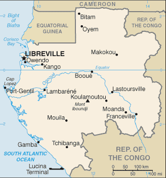
| Administrative divisions: | 9 provinces; Estuaire , Haut-Ogooue , Moyen-Ogooue , Ngounie , Nyanga , Ogooue-Ivindo , Ogooue-Lolo , Ogooue-Maritime , Woleu-Ntem |
| Area: | total: 267 ,667 sq km land: 257 ,667 sq km water: 10 ,000 sq km |
| Background: | Only two autocratic presidents have ruled Gabon since independence from France in 1960. The current president of Gabon , El Hadj Omar BONGO Ondimba - one of the longest-serving heads of state in the world - has dominated the country's political scene for four decades. President BONGO introduced a nominal multiparty system and a new constitution in the early 1990s. However , allegations of electoral fraud during local elections in 2002-03 and the presidential elections in 2005 have exposed the weaknesses of formal political structures in Gabon. Gabon's political opposition remains weak , divided , and financially dependent on the current regime. Despite political conditions , a small population , abundant natural resources , and considerable foreign support have helped make Gabon one of the more prosperous and stable African countries. |
| Flag description: | three equal horizontal bands of green (top) , yellow , and blue |
| Capital: | name: Libreville geographic coordinates: 0 23 N , 9 27 E time difference: UTC+1 (6 hours ahead of Washington , DC during Standard Time) |
| Climate: | tropical; always hot , humid |
| Currency code: | Communaute Financiere Africaine franc (XAF); note - responsible authority is the Bank of the Central African States |
| Ethnic groups: | Bantu tribes , including four major tribal groupings (Fang , Bapounou , Nzebi , Obamba); other Africans and Europeans , 154 ,000 , including 10 ,700 French and 11 ,000 persons of dual nationality |
| Geographic coordinates: | 1 00 S , 11 45 E |
| Geography note: | a small population and oil and mineral reserves have helped Gabon become one of Africa's wealthier countries; in general , these circumstances have allowed the country to maintain and conserve its pristine rain forest and rich biodiversity |
| Government type: | republic; multiparty presidential regime |
| Imports partners: | France 28.1% , US 19.3% , Belgium 5.5% , Netherlands 4.8% , China 4.2% (2007) |
| Internet country code: | .ga |
| Land boundaries: | 885 km |
| Neighbouring countries: | total: 2 ,551 km border countries: Cameroon 298 km , Republic of the Congo 1 ,903 km , Equatorial Guinea 350 km |
| Languages: | French (official) , Fang , Myene , Nzebi , Bapounou/Eschira , Bandjabi |
| Location: | |
| Map references: | Africa |
| National holiday: | Independence Day , 17 August (1960) |
| Nationality: | noun: Gabonese (singular and plural) adjective: Gabonese |
| Natural hazards: | NA |
| Population: | 1 ,485 ,832 note: estimates for this country explicitly take into account the effects of excess mortality due to AIDS; this can result in lower life expectancy , higher infant mortality , higher death rates , lower population growth rates , and changes in the distribution of population by age and sex than would otherwise be expected (July 2008 est.) |
| Religions: | Christian 55%-75% , animist , Muslim less than 1% |
| Terrain: | narrow coastal plain; hilly interior; savanna in east and south |
| Unemployment rate: | 21% (2006 est.) |
Capital of Gabonese Republic
Libreville (click to view Libreville map)
Places in Gabon
Browse the most comprehensive and up-to-date online directory of administrative regions and Street Views in Gabon. Our listings are organized alphabetically, starting from level 1 regions and progressing through to level 2 and eventually level 3 regions, ensuring you can easily navigate and find specific areas of interest.
Haut-Ogooué Province (300 google map locations)
Moyen-Ogooué Province (261 google map locations)
Ngounié Province (670 google map locations)
Nyanga Province (345 google map locations)
Ogooué-Lolo Province (359 google map locations)
Ogooué-Maritime Province (200 google map locations)
Woleu-Ntem Province (698 google map locations)
Random cities in Gabon
Libreville, the capital city of Gabon.Ango
Otala
Maoumba
Yelo
Paguilou
Ebounfaga
Kéno
Bongo
Massoti
Aféma
Angone II
Binanga
Ngonga
Mbigou
Etsamé I
Ombala
Orali
Mbafan
Massoli Oubala
Link to Gabon Google Maps page
The map of Gabon has already attracted 4389 views. If you wish to embed our comprehensive Gabon map on your site, we offer an easy solution. This map includes free access to Google Maps, gazetteer search, detailed country and city maps, Street View, and essential facts, all ready to enhance your website. To use it, simply copy and paste the provided HTML code into your webpage's source code. We appreciate every link back to our Maps and Driving Directions. Thank you for your support!
| Text link to: Gabon map and facts page |
This Gabon map is intended solely for informational purposes. No representations or warranties are made concerning its accuracy or reliability. Users assume all risks associated with the use of Google Maps and Google Driving Directions. World Route Planner is not liable for any losses or delays that may occur from using this free Gabon map.