 Republic of Guinea-Bissau Google Maps and Facts
Welcome to the Google Maps of Guinea-Bissau (GW) and the comprehensive location list for this country. World Route Planner, together with its detailed Guinea-Bissau page, turns Google Maps Sightseeing into a meaningful experience! Our extensive destination gazetteer, coupled with Driving Directions to Guinea-Bissau, allows you to explore Guinea-Bissau through detailed satellite imagery and street views—fast, free, and easier than ever before.
Browse through the list of administrative regions in Guinea-Bissau, navigate through these regions to find a place of interest, and book your hotel with the Best Price Guarantee! Your journey through Guinea-Bissau via Google Satellite Map Sightseeing and Street View starts here.
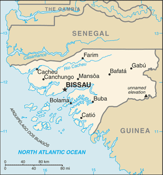
Guinea-Bissau Google Maps
To activate Street View on any city of Guinea-Bissau, drag above the Zoom feature the yellow little man in the map.
Facts about Guinea-Bissau
| Administrative divisions: | 9 regions (regioes , singular - regiao); Bafata , Biombo , Bissau , Bolama , Cacheu , Gabu , Oio , Quinara , Tombali; note - Bolama may have been renamed Bolama/Bijagos |
| Area: | total: 36 ,120 sq km land: 28 ,000 sq km water: 8 ,120 sq km |
| Background: | Since independence from Portugal in 1974 , Guinea-Bissau has experienced considerable political and military upheaval. In 1980 , a military coup established authoritarian dictator Joao Bernardo 'Nino' VIEIRA as president. Despite setting a path to a market economy and multiparty system , VIEIRA's regime was characterized by the suppression of political opposition and the purging of political rivals. Several coup attempts through the 1980s and early 1990s failed to unseat him. In 1994 VIEIRA was elected president in the country's first free elections. A military mutiny and resulting civil war in 1998 eventually led to VIEIRA's ouster in May 1999. In February 2000 , a transitional government turned over power to opposition leader Kumba YALA , after he was elected president in transparent polling. In September 2003 , after only three years in office , YALA was ousted by the military in a bloodless coup , and businessman Henrique ROSA was sworn in as interim president. In 2005 , former President VIEIRA was re-elected president pledging to pursue economic development and national reconciliation. |
| Flag description: | two equal horizontal bands of yellow (top) and green with a vertical red band on the hoist side; there is a black five-pointed star centered in the red band; uses the popular pan-African colors of Ethiopia |
| Capital: | name: Bissau geographic coordinates: 11 51 N , 15 35 W time difference: UTC 0 (5 hours ahead of Washington , DC during Standard Time) |
| Climate: | tropical; generally hot and humid; monsoonal-type rainy season (June to November) with southwesterly winds; dry season (December to May) with northeasterly harmattan winds |
| Currency code: | Communaute Financiere Africaine franc (XOF); note - responsible authority is the Central Bank of the West African States |
| Ethnic groups: | African 99% (includes Balanta 30% , Fula 20% , Manjaca 14% , Mandinga 13% , Papel 7%) , European and mulatto less than 1% |
| Geographic coordinates: | 12 00 N , 15 00 W |
| Geography note: | this small country is swampy along its western coast and low-lying inland |
| Government type: | republic |
| Imports partners: | Portugal 21.5% , Senegal 16.8% , France 6% , Pakistan 4.7% (2007) |
| Internet country code: | .gw |
| Land boundaries: | 350 km |
| Neighbouring countries: | total: 724 km border countries: Guinea 386 km , Senegal 338 km |
| Languages: | Portuguese (official) , Crioulo , African languages |
| Location: | Western Africa , bordering the North Atlantic Ocean , between Guinea and Senegal |
| Map references: | Africa |
| National holiday: | Independence Day , 24 September (1973) |
| Nationality: | noun: Guinean(s) adjective: Guinean |
| Natural hazards: | hot , dry , dusty harmattan haze may reduce visibility during dry season; brush fires |
| Population: | 1 ,503 ,182 (July 2008 est.) |
| Religions: | Muslim 50% , indigenous beliefs 40% , Christian 10% |
| Terrain: | mostly low coastal plain rising to savanna in east |
| Unemployment rate: | NA% |
Capital of Republic of Guinea-Bissau
Bissau (click to view Bissau map)
Places in Guinea-Bissau
Browse the most comprehensive and up-to-date online directory of administrative regions and Street Views in Guinea-Bissau. Our listings are organized alphabetically, starting from level 1 regions and progressing through to level 2 and eventually level 3 regions, ensuring you can easily navigate and find specific areas of interest.
Aldeia city Google map
Aliu Jai city Google map
Amedalai city Google map
Bafata Region (770 google map locations)
Bembelo city Google map
Biombo Region (119 google map locations)
Bissâmal city Google map
Bissau Autonomous Sector (62 google map locations)
Bolama Region (164 google map locations)
Bricama city Google map
Cacheu Region (612 google map locations)
Cambaju city Google map
Cambéssè city Google map
Cancubanhe Sinchã city Google map
Candembuia city Google map
Canfate city Google map
Canhaga city Google map
Canjara city Google map
Canxelebel city Google map
Carantabá city Google map
Catabá city Google map
Changael Singálà city Google map
Dando city Google map
Daro Nhaco city Google map
Darsalame city Google map
Demba city Google map
Demba Danejo city Google map
Demosor city Google map
Duà city Google map
Embalocunda city Google map
Faquina Fula city Google map
Faquina Mandinga city Google map
Gabu Region (755 google map locations)
Galomaro city Google map
Ganhala city Google map
Gêba city Google map
Ginane city Google map
Jabadá city Google map
Jaljalto city Google map
Jambur city Google map
Junqueira city Google map
Madina city Google map
Madina Mansali city Google map
Mamaconom city Google map
Mamboncò city Google map
Mampatá city Google map
Mato Grande city Google map
Micheche city Google map
Oio Region (620 google map locations)
Pate Baliel city Google map
Ponta Manuel Vieira city Google map
Ponta Nhamudefè city Google map
Queber city Google map
Quinara Region (345 google map locations)
Sálià city Google map
Samba Daba city Google map
Sambuià city Google map
Sana Marum city Google map
Sancalancunda city Google map
Sare Adè city Google map
Sare Anambé city Google map
Sare Ardo city Google map
Sare Birom city Google map
Sare Canta city Google map
Sare Chicamo city Google map
Sare Chumbo city Google map
Sare Cobà city Google map
Sare Cubè city Google map
Sare Demba Baderal city Google map
Sare Ganà city Google map
Sare Gêba city Google map
Sare Iero city Google map
Sare Ierobà city Google map
Sare Ioba city Google map
Sare Janque city Google map
Sare Jomel city Google map
Sare Nhado city Google map
Sare Pati city Google map
Sauiã city Google map
Sinchã Agostinho city Google map
Sinchã Ali city Google map
Sinchã Bácar city Google map
Sinchã Bambè city Google map
Sinchã Búquel city Google map
Sinchã Camisa city Google map
Sinchã Corga city Google map
Sinchã Délè city Google map
Sinchã Dulá city Google map
Sinchã Fajonquito city Google map
Sinchã Famora city Google map
Sinchã Guelà city Google map
Sinchã Iero Leluma city Google map
Sinchã Mamudo city Google map
Sinchã Saído city Google map
Sinchã Samba Sunto city Google map
Sinchã Sutu city Google map
Sinchã Uale city Google map
Soncò city Google map
Sumbundo city Google map
Tabató city Google map
Tambato city Google map
Tendinto city Google map
Tombali Region (371 google map locations)
Ualicunda city Google map
Uassadu city Google map
Random cities in Guinea-Bissau
Bissau, the capital city of Guinea-Bissau.Nhapo
Catábà Fali
Nhala de Cima
Contumo
Sinchã Saído
Jamossé
Sinchã Samba Camarà
Sinchã Usso
Gamamudo
Sinchã Labi
Bachetecor
Bironque
Hèlacunda
Sinchã Nafà
Sinchã Talá
Jomelcunda
Sinchã Mussa
Tade
Sirael
Link to Guinea-Bissau Google Maps page
The map of Guinea-Bissau has already attracted 3072 views. If you wish to embed our comprehensive Guinea-Bissau map on your site, we offer an easy solution. This map includes free access to Google Maps, gazetteer search, detailed country and city maps, Street View, and essential facts, all ready to enhance your website. To use it, simply copy and paste the provided HTML code into your webpage's source code. We appreciate every link back to our Maps and Driving Directions. Thank you for your support!
| Text link to: Guinea-Bissau map and facts page |
This Guinea-Bissau map is intended solely for informational purposes. No representations or warranties are made concerning its accuracy or reliability. Users assume all risks associated with the use of Google Maps and Google Driving Directions. World Route Planner is not liable for any losses or delays that may occur from using this free Guinea-Bissau map.