 Kingdom of Lesotho Google Maps and Facts
Welcome to the Google Maps of Lesotho (LS) and the comprehensive location list for this country. World Route Planner, together with its detailed Lesotho page, turns Google Maps Sightseeing into a meaningful experience! Our extensive destination gazetteer, coupled with Driving Directions to Lesotho, allows you to explore Lesotho through detailed satellite imagery and street views—fast, free, and easier than ever before.
Browse through the list of administrative regions in Lesotho, navigate through these regions to find a place of interest, and book your hotel with the Best Price Guarantee! Your journey through Lesotho via Google Satellite Map Sightseeing and Street View starts here.
Lesotho Google Maps
To activate Street View on any city of Lesotho, drag above the Zoom feature the yellow little man in the map.
Facts about Lesotho
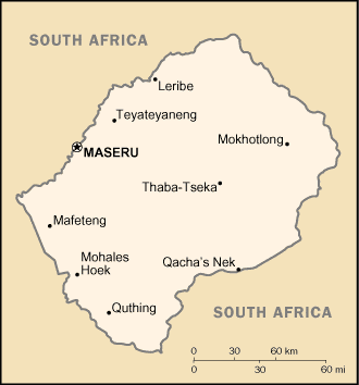
| Administrative divisions: | 10 districts; Berea , Butha-Buthe , Leribe , Mafeteng , Maseru , Mohale's Hoek , Mokhotlong , Qacha's Nek , Quthing , Thaba-Tseka |
| Area: | total: 30 ,355 sq km land: 30 ,355 sq km water: 0 sq km |
| Background: | Basutoland was renamed the Kingdom of Lesotho upon independence from the UK in 1966. The Basuto National Party ruled for the first two decades. King MOSHOESHOE was exiled in 1990 , but returned to Lesotho in 1992 and was reinstated in 1995. Constitutional government was restored in 1993 after seven years of military rule. In 1998 , violent protests and a military mutiny following a contentious election prompted a brief but bloody intervention by South African and Botswanan military forces under the aegis of the Southern African Development Community. Subsequent constitutional reforms restored relative political stability. Peaceful parliamentary elections were held in 2002 , but the National Assembly elections of February 2007 were hotly contested and aggrieved parties continue to periodically demonstrate their distrust of the results. |
| Flag description: | three horizontal stripes of blue (top) , white , and green in the proportions of 3:4:3; the colors represent rain , peace , and prosperity respectively; centered in the white stripe is a black Basotho hat representing the indigenous people; the flag was unfurled in October 2006 to celebrate 40 years of independence |
| Capital: | name: Maseru geographic coordinates: 29 19 S , 27 29 E time difference: UTC+2 (7 hours ahead of Washington , DC during Standard Time) |
| Climate: | temperate; cool to cold , dry winters; hot , wet summers |
| Currency code: | loti (LSL); South African rand (ZAR) |
| Ethnic groups: | Sotho 99.7% , Europeans , Asians , and other 0.3% , |
| Geographic coordinates: | 29 30 S , 28 30 E |
| Geography note: | landlocked , completely surrounded by South Africa; mountainous , more than 80% of the country is 1 ,800 m above sea level |
| Government type: | parliamentary constitutional monarchy |
| Imports partners: | China 30% , Hong Kong 29.6% , India 10% , South Korea 6.6% , Germany 6.4% , Pakistan 4.6% (2007) |
| Internet country code: | .ls |
| Land boundaries: | 0 km (landlocked) |
| Neighbouring countries: | total: 909 km border countries: South Africa 909 km |
| Languages: | Sesotho (southern Sotho) , English (official) , Zulu , Xhosa |
| Location: | Southern Africa , an enclave of South Africa |
| Map references: | Africa |
| National holiday: | Independence Day , 4 October (1966) |
| Nationality: | noun: Mosotho (singular) , Basotho (plural) adjective: Basotho |
| Natural hazards: | periodic droughts |
| Population: | 2 ,128 ,180 note: estimates for this country explicitly take into account the effects of excess mortality due to AIDS; this can result in lower life expectancy , higher infant mortality , higher death rates , lower population growth rates , and changes in the distribution of population by age and sex than would otherwise be expected (July 2008 est.) |
| Religions: | Christian 80% , indigenous beliefs 20% |
| Terrain: | mostly highland with plateaus , hills , and mountains |
| Unemployment rate: | 45% (2002) |
Capital of Kingdom of Lesotho
Maseru (click to view Maseru map)
Places in Lesotho
Browse the most comprehensive and up-to-date online directory of administrative regions and Street Views in Lesotho. Our listings are organized alphabetically, starting from level 1 regions and progressing through to level 2 and eventually level 3 regions, ensuring you can easily navigate and find specific areas of interest.
Butha-Buthe District (24 google map locations)
Leribe District (23 google map locations)
Mafeteng District (48 google map locations)
Maseru District (58 google map locations)
Mokhotlong District (7 google map locations)
Qacha's Nek District (8 google map locations)
Quthing District (19 google map locations)
Thaba-Tseka District (8 google map locations)
Random cities in Lesotho
Maseru, the capital city of Lesotho.Maghalleen
Tosing
Mutlanyane
Tsoelike
Letsikas
Kelechane
Phafoli
Molomos Hoek
Liphateng
Mantsa
Mantoetsi
Schoolplaats
Joel
Riet Vlei
Ntlamas
Mpobong
Theetsoa
Siloe
Motloang
Link to Lesotho Google Maps page
The map of Lesotho has already attracted 10427 views. If you wish to embed our comprehensive Lesotho map on your site, we offer an easy solution. This map includes free access to Google Maps, gazetteer search, detailed country and city maps, Street View, and essential facts, all ready to enhance your website. To use it, simply copy and paste the provided HTML code into your webpage's source code. We appreciate every link back to our Maps and Driving Directions. Thank you for your support!
| Text link to: Lesotho map and facts page |
This Lesotho map is intended solely for informational purposes. No representations or warranties are made concerning its accuracy or reliability. Users assume all risks associated with the use of Google Maps and Google Driving Directions. World Route Planner is not liable for any losses or delays that may occur from using this free Lesotho map.