 Republic of Madagascar Google Maps and Facts
Welcome to the Google Maps of Madagascar (MG) and the comprehensive location list for this country. World Route Planner, together with its detailed Madagascar page, turns Google Maps Sightseeing into a meaningful experience! Our extensive destination gazetteer, coupled with Driving Directions to Madagascar, allows you to explore Madagascar through detailed satellite imagery and street views—fast, free, and easier than ever before.
Browse through the list of administrative regions in Madagascar, navigate through these regions to find a place of interest, and book your hotel with the Best Price Guarantee! Your journey through Madagascar via Google Satellite Map Sightseeing and Street View starts here.
Madagascar Google Maps
To activate Street View on any city of Madagascar, drag above the Zoom feature the yellow little man in the map.
Facts about Madagascar
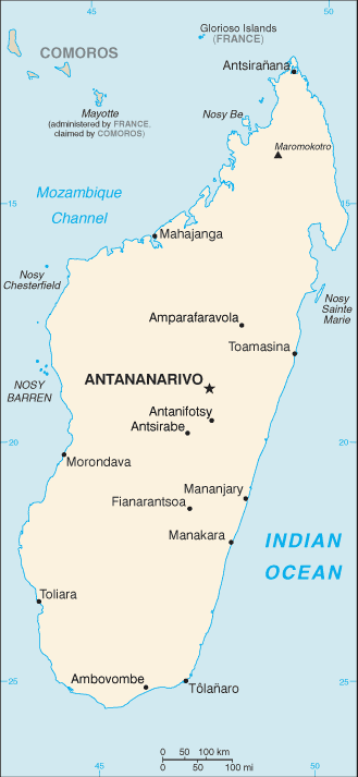
| Administrative divisions: | 6 provinces (faritany); Antananarivo , Antsiranana , Fianarantsoa , Mahajanga , Toamasina , Toliara |
| Area: | total: 587 ,040 sq km land: 581 ,540 sq km water: 5 ,500 sq km |
| Background: | Formerly an independent kingdom , Madagascar became a French colony in 1896 but regained independence in 1960. During 1992-93 , free presidential and National Assembly elections were held ending 17 years of single-party rule. In 1997 , in the second presidential race , Didier RATSIRAKA , the leader during the 1970s and 1980s , was returned to the presidency. The 2001 presidential election was contested between the followers of Didier RATSIRAKA and Marc RAVALOMANANA , nearly causing secession of half of the country. In April 2002 , the High Constitutional Court announced RAVALOMANANA the winner. RAVALOMANANA is now in his second term following a landslide victory in the generally free and fair presidential elections of 2006. |
| Flag description: | two equal horizontal bands of red (top) and green with a vertical white band of the same width on hoist side |
| Capital: | name: Antananarivo geographic coordinates: 18 55 S , 47 31 E time difference: UTC+3 (8 hours ahead of Washington , DC during Standard Time) |
| Climate: | tropical along coast , temperate inland , arid in south |
| Currency code: | ariary (MGA) |
| Ethnic groups: | Malayo-Indonesian (Merina and related Betsileo) , Cotiers (mixed African , Malayo-Indonesian , and Arab ancestry - Betsimisaraka , Tsimihety , Antaisaka , Sakalava) , French , Indian , Creole , Comoran |
| Geographic coordinates: | 20 00 S , 47 00 E |
| Geography note: | world's fourth-largest island; strategic location along Mozambique Channel |
| Government type: | republic |
| Imports partners: | France 13.6% , China 13.1% , Iran 8.2% , South Africa 6.4% , Mauritius 5.1% , Hong Kong 4.9% (2007) |
| Internet country code: | .mg |
| Land boundaries: | 4 ,828 km |
| Neighbouring countries: | 0 km |
| Languages: | English (official) , French (official) , Malagasy (official) |
| Location: | Southern Africa , island in the Indian Ocean , east of Mozambique |
| Map references: | Africa |
| National holiday: | Independence Day , 26 June (1960) |
| Nationality: | noun: Malagasy (singular and plural) adjective: Malagasy |
| Natural hazards: | periodic cyclones , drought , and locust infestation |
| Population: | 20 ,042 ,552 (July 2008 est.) |
| Religions: | indigenous beliefs 52% , Christian 41% , Muslim 7% |
| Terrain: | narrow coastal plain , high plateau and mountains in center |
| Unemployment rate: |
Capital of Republic of Madagascar
Antananarivo (click to view Antananarivo map)
Places in Madagascar
Browse the most comprehensive and up-to-date online directory of administrative regions and Street Views in Madagascar. Our listings are organized alphabetically, starting from level 1 regions and progressing through to level 2 and eventually level 3 regions, ensuring you can easily navigate and find specific areas of interest.
Antsiranana Province (1257 google map locations)
Fianarantsoa Province (2717 google map locations)
Toamasina Province (1709 google map locations)
Toliara Province (3231 google map locations)
Random cities in Madagascar
Antananarivo, the capital city of Madagascar.Antsotabato
Andranopositra
Saint Anne
Mandiameva
Amboahangimamy
Begavo
Ambatolongo
Marovitsika
Antsahalana
Sahankazo Ambony
Mandendamba
Fieferana
Kidamota
Bevato
Ambalengitra
Analalava
Fenoevo
Anjanamahazo
Tsarafara
Link to Madagascar Google Maps page
The map of Madagascar has already attracted 5106 views. If you wish to embed our comprehensive Madagascar map on your site, we offer an easy solution. This map includes free access to Google Maps, gazetteer search, detailed country and city maps, Street View, and essential facts, all ready to enhance your website. To use it, simply copy and paste the provided HTML code into your webpage's source code. We appreciate every link back to our Maps and Driving Directions. Thank you for your support!
| Text link to: Madagascar map and facts page |
This Madagascar map is intended solely for informational purposes. No representations or warranties are made concerning its accuracy or reliability. Users assume all risks associated with the use of Google Maps and Google Driving Directions. World Route Planner is not liable for any losses or delays that may occur from using this free Madagascar map.