 Republic of Namibia Google Maps and Facts
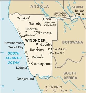
Welcome to the Google Maps of Namibia (NA) and the comprehensive location list for this country. World Route Planner, together with its detailed Namibia page, turns Google Maps Sightseeing into a meaningful experience! Our extensive destination gazetteer, coupled with Driving Directions to Namibia, allows you to explore Namibia through detailed satellite imagery and street views—fast, free, and easier than ever before.
Browse through the list of administrative regions in Namibia, navigate through these regions to find a place of interest, and book your hotel with the Best Price Guarantee! Your journey through Namibia via Google Satellite Map Sightseeing and Street View starts here.
Namibia Google Maps
To activate Street View on any city of Namibia, drag above the Zoom feature the yellow little man in the map.
Facts about Namibia
| Administrative divisions: | 13 regions; Caprivi , Erongo , Hardap , Karas , Khomas , Kunene , Ohangwena , Okavango , Omaheke , Omusati , Oshana , Oshikoto , Otjozondjupa |
| Area: | total: 825 ,418 sq km land: 825 ,418 sq km water: 0 sq km |
| Background: | South Africa occupied the German colony of South-West Africa during World War I and administered it as a mandate until after World War II , when it annexed the territory. In 1966 the Marxist South-West Africa People's Organization (SWAPO) guerrilla group launched a war of independence for the area that was soon named Namibia , but it was not until 1988 that South Africa agreed to end its administration in accordance with a UN peace plan for the entire region. Namibia has been governed by SWAPO since the country won independence in 1990. Hifikepunye POHAMBA was elected president in November 2004 in a landslide victory replacing Sam NUJOMA who led the country during its first 14 years of self rule. |
| Flag description: | a wide red stripe edged by narrow white stripes divides the flag diagonally from lower hoist corner to upper fly corner; the upper hoist-side triangle is blue and charged with a yellow , 12-rayed sunburst; the lower fly-side triangle is green |
| Capital: | name: Windhoek geographic coordinates: 22 34 S , 17 05 E time difference: UTC+1 (6 hours ahead of Washington , DC during Standard Time) daylight saving time: +1hr , begins first Sunday in September; ends first Sunday in April |
| Climate: | desert; hot , dry; rainfall sparse and erratic |
| Currency code: | Namibian dollar (NAD); South African rand (ZAR) |
| Ethnic groups: | black 87.5% , white 6% , mixed 6.5% note: about 50% of the population belong to the Ovambo tribe and 9% to the Kavangos tribe; other ethnic groups include Herero 7% , Damara 7% , Nama 5% , Caprivian 4% , Bushmen 3% , Baster 2% , Tswana 0.5% |
| Geographic coordinates: | 22 00 S , 17 00 E |
| Geography note: | first country in the world to incorporate the protection of the environment into its constitution; some 14% of the land is protected , including virtually the entire Namib Desert coastal strip |
| Government type: | republic |
| Imports partners: | South Africa 85.2% , US (2006) |
| Internet country code: | .na |
| Land boundaries: | 1 ,572 km |
| Neighbouring countries: | total: 3 ,936 km border countries: Angola 1 ,376 km , Botswana 1 ,360 km , South Africa 967 km , Zambia 233 km |
| Languages: | English 7% (official) , Afrikaans common language of most of the population and about 60% of the white population , German 32% , indigenous languages 1% (includes Oshivambo , Herero , Nama) |
| Location: | Southern Africa , bordering the South Atlantic Ocean , between Angola and South Africa |
| Map references: | Africa |
| National holiday: | Independence Day , 21 March (1990) |
| Nationality: | noun: Namibian(s) adjective: Namibian |
| Natural hazards: | prolonged periods of drought |
| Population: | 2 ,088 ,669 note: estimates for this country explicitly take into account the effects of excess mortality due to AIDS; this can result in lower life expectancy , higher infant mortality , higher death rates , lower population growth rates , and changes in the distribution of population by age and sex than would otherwise be expected (July 2008 est.) |
| Religions: | Christian 80% to 90% (Lutheran 50% at least) , indigenous beliefs 10% to 20% |
| Terrain: | mostly high plateau; Namib Desert along coast; Kalahari Desert in east |
| Unemployment rate: | 5.2% (2007 est.) |
Capital of Republic of Namibia
Windhoek (click to view Windhoek map)
Places in Namibia
Browse the most comprehensive and up-to-date online directory of administrative regions and Street Views in Namibia. Our listings are organized alphabetically, starting from level 1 regions and progressing through to level 2 and eventually level 3 regions, ensuring you can easily navigate and find specific areas of interest.
Erongo Region (99 google map locations)
Hardap Region (53 google map locations)
Karas Region (154 google map locations)
Khomas Region (139 google map locations)
Kunene Region (179 google map locations)
Ohangwena Region (204 google map locations)
Omaheke Region (81 google map locations)
Omusati Region (126 google map locations)
Oshana Region (48 google map locations)
Oshikoto Region (152 google map locations)
Otjozondjupa Region (149 google map locations)
Random cities in Namibia
Windhoek, the capital city of Namibia.Kwena
Imkerhof
Arabia
Tavauka
Lyakahani
Kadedere
Ohangwena
Okalongo
Onangava
Oranjemund
Omitara
Palmenhorst
Ombahe-Yakako
Siveyo
Epato
Omaalala
Dreihuk
Oshikiyu
Siongo
Link to Namibia Google Maps page
The map of Namibia has already attracted 7384 views. If you wish to embed our comprehensive Namibia map on your site, we offer an easy solution. This map includes free access to Google Maps, gazetteer search, detailed country and city maps, Street View, and essential facts, all ready to enhance your website. To use it, simply copy and paste the provided HTML code into your webpage's source code. We appreciate every link back to our Maps and Driving Directions. Thank you for your support!
| Text link to: Namibia map and facts page |
This Namibia map is intended solely for informational purposes. No representations or warranties are made concerning its accuracy or reliability. Users assume all risks associated with the use of Google Maps and Google Driving Directions. World Route Planner is not liable for any losses or delays that may occur from using this free Namibia map.