 Republic of Niger Google Maps and Facts
Welcome to the Google Maps of Niger (NE) and the comprehensive location list for this country. World Route Planner, together with its detailed Niger page, turns Google Maps Sightseeing into a meaningful experience! Our extensive destination gazetteer, coupled with Driving Directions to Niger, allows you to explore Niger through detailed satellite imagery and street views—fast, free, and easier than ever before.
Browse through the list of administrative regions in Niger, navigate through these regions to find a place of interest, and book your hotel with the Best Price Guarantee! Your journey through Niger via Google Satellite Map Sightseeing and Street View starts here.
Niger Google Maps
To activate Street View on any city of Niger, drag above the Zoom feature the yellow little man in the map.
Facts about Niger
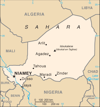
| Administrative divisions: | 8 regions (regions , singular - region) includes 1 capital district* (communite urbaine); Agadez , Diffa , Dosso , Maradi , Niamey* , Tahoua , Tillaberi , Zinder |
| Area: | total: 1.267 million sq km land: 1 ,266 ,700 sq km water: 300 sq km |
| Background: | Niger became independent from France in 1960 and experienced single-party and military rule until 1991 , when Gen. Ali SAIBOU was forced by public pressure to allow multiparty elections , which resulted in a democratic government in 1993. Political infighting brought the government to a standstill and in 1996 led to a coup by Col. Ibrahim BARE. In 1999 BARE was killed in a coup by military officers who promptly restored democratic rule and held elections that brought Mamadou TANDJA to power in December of that year. TANDJA was reelected in 2004. Niger is one of the poorest countries in the world with minimal government services and insufficient funds to develop its resource base. The largely agrarian and subsistence-based economy is frequently disrupted by extended droughts common to the Sahel region of Africa. A predominately Tuareg ethnic group emerged in February 2007 , the Nigerien Movement for Justice (MNJ) , and attacked several military targets in Niger's northern region throughout 2007. Events have since evolved into a budding insurrection. |
| Flag description: | three equal horizontal bands of orange (top) , white , and green with a small orange disk (representing the sun) centered in the white band; similar to the flag of India , which has a blue spoked wheel centered in the white band |
| Capital: | name: Niamey geographic coordinates: 13 31 N , 2 07 E time difference: UTC+1 (6 hours ahead of Washington , DC during Standard Time) |
| Climate: | desert; mostly hot , dry , dusty; tropical in extreme south |
| Currency code: | Communaute Financiere Africaine franc (XOF); note - responsible authority is the Central Bank of the West African States |
| Ethnic groups: | Haoussa 55.4% , Djerma Sonrai 21% , Tuareg 9.3% , Peuhl 8.5% , Kanouri Manga 4.7% , other 1.2% (2001 census) |
| Geographic coordinates: | 16 00 N , 8 00 E |
| Geography note: | landlocked; one of the hottest countries in the world; northern four-fifths is desert , southern one-fifth is savanna , suitable for livestock and limited agriculture |
| Government type: | republic |
| Imports partners: | France 15.5% , French Polynesia 8.5% , Nigeria 8.3% , Belgium 8.3% , US 6.7% , Cote d'Ivoire 5.5% (2007) |
| Internet country code: | .ne |
| Land boundaries: | 0 km (landlocked) |
| Neighbouring countries: | total: 5 ,697 km border countries: Algeria 956 km , Benin 266 km , Burkina Faso 628 km , Chad 1 ,175 km , Libya 354 km , Mali 821 km , Nigeria 1 ,497 km |
| Languages: | French (official) , Hausa , Djerma |
| Location: | Western Africa , southeast of Algeria |
| Map references: | Africa |
| National holiday: | Republic Day , 18 December (1958) |
| Nationality: | noun: Nigerien(s) adjective: Nigerien |
| Natural hazards: | recurring droughts |
| Population: | 13 ,272 ,679 (July 2008 est.) |
| Religions: | Muslim 80% , other (includes indigenous beliefs and Christian) 20% |
| Terrain: | predominately desert plains and sand dunes; flat to rolling plains in south; hills in north |
| Unemployment rate: | NA% |
Capital of Republic of Niger
Niamey (click to view Niamey map)
Places in Niger
Browse the most comprehensive and up-to-date online directory of administrative regions and Street Views in Niger. Our listings are organized alphabetically, starting from level 1 regions and progressing through to level 2 and eventually level 3 regions, ensuring you can easily navigate and find specific areas of interest.
Département de Tillabéri (175 google map locations)
Diffa Department (157 google map locations)
Dosso Department (1371 google map locations)
Niamey (1516 google map locations)
Tahoua Department (489 google map locations)
Zinder Department (821 google map locations)
Random cities in Niger
Niamey, the capital city of Niger.Dan Ja Amouté
Malé
Gazourawa
Guidan Badoukou
Sabarou
Ouro Sawabé
Guidan Kani
Saïdou Bidawa
Yooukoyré
Guidan Agada
Garin Mayaki
Wandé Baba
Gobérawa
Téra
Gangala
Dourougouna
Dan Bagou
Atri
Koylami
Link to Niger Google Maps page
The map of Niger has already attracted 5285 views. If you wish to embed our comprehensive Niger map on your site, we offer an easy solution. This map includes free access to Google Maps, gazetteer search, detailed country and city maps, Street View, and essential facts, all ready to enhance your website. To use it, simply copy and paste the provided HTML code into your webpage's source code. We appreciate every link back to our Maps and Driving Directions. Thank you for your support!
| Text link to: Niger map and facts page |
This Niger map is intended solely for informational purposes. No representations or warranties are made concerning its accuracy or reliability. Users assume all risks associated with the use of Google Maps and Google Driving Directions. World Route Planner is not liable for any losses or delays that may occur from using this free Niger map.