 Kingdom of Swaziland Google Maps and Facts
Welcome to the Google Maps of Swaziland (SZ) and the comprehensive location list for this country. World Route Planner, together with its detailed Swaziland page, turns Google Maps Sightseeing into a meaningful experience! Our extensive destination gazetteer, coupled with Driving Directions to Swaziland, allows you to explore Swaziland through detailed satellite imagery and street views—fast, free, and easier than ever before.
Browse through the list of administrative regions in Swaziland, navigate through these regions to find a place of interest, and book your hotel with the Best Price Guarantee! Your journey through Swaziland via Google Satellite Map Sightseeing and Street View starts here.
Swaziland Google Maps
To activate Street View on any city of Swaziland, drag above the Zoom feature the yellow little man in the map.
Facts about Swaziland
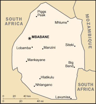
| Administrative divisions: | 4 districts; Hhohho , Lubombo , Manzini , Shiselweni |
| Area: | total: 17 ,363 sq km land: 17 ,203 sq km water: 160 sq km |
| Background: | Autonomy for the Swazis of southern Africa was guaranteed by the British in the late 19th century; independence was granted in 1968. Student and labor unrest during the 1990s pressured King MSWATI III , the world's last absolute monarch , to grudgingly allow political reform and greater democracy , although he has backslid on these promises in recent years. A constitution came into effect in 2006 , but political parties remain banned. The African United Democratic Party tried unsuccessfully to register as an official political party in mid 2006. Talks over the constitution broke down between the government and progressive groups in 2007. Swaziland recently surpassed Botswana as the country with the world's highest known HIV/AIDS prevalence rate. |
| Flag description: | three horizontal bands of blue (top) , red (triple width) , and blue; the red band is edged in yellow; centered in the red band is a large black and white shield covering two spears and a staff decorated with feather tassels , all placed horizontally |
| Capital: | name: Mbabane geographic coordinates: 26 18 S , 31 06 E time difference: UTC+2 (7 hours ahead of Washington , DC during Standard Time) note: Lobamba (royal and legislative capital) |
| Climate: | varies from tropical to near temperate |
| Currency code: | |
| Ethnic groups: | African 97% , European 3% |
| Geographic coordinates: | 26 30 S , 31 30 E |
| Geography note: | landlocked; almost completely surrounded by South Africa |
| Government type: | monarchy |
| Imports partners: | South Africa 95.6% , EU 0.9% , Japan 0.9% (2006) |
| Internet country code: | .sz |
| Land boundaries: | 0 km (landlocked) |
| Neighbouring countries: | total: 535 km border countries: Mozambique 105 km , South Africa 430 km |
| Languages: | English (official , government business conducted in English) , siSwati (official) |
| Location: | Southern Africa , between Mozambique and South Africa |
| Map references: | Africa |
| National holiday: | Independence Day , 6 September (1968) |
| Nationality: | noun: Swazi(s) adjective: Swazi |
| Natural hazards: | drought |
| Population: | 1 ,128 ,814 note: estimates for this country explicitly take into account the effects of excess mortality due to AIDS; this can result in lower life expectancy , higher infant mortality , higher death rates , lower population growth rates , and changes in the distribution of population by age and sex than would otherwise be expected (July 2008 est.) |
| Religions: | Zionist 40% (a blend of Christianity and indigenous ancestral worship) , Roman Catholic 20% , Muslim 10% , other (includes Anglican , Bahai , Methodist , Mormon , Jewish) 30% |
| Terrain: | mostly mountains and hills; some moderately sloping plains |
| Unemployment rate: | 40% (2006 est.) |
Capital of Kingdom of Swaziland
Lobamba (click to view Lobamba map)
Places in Swaziland
Browse the most comprehensive and up-to-date online directory of administrative regions and Street Views in Swaziland. Our listings are organized alphabetically, starting from level 1 regions and progressing through to level 2 and eventually level 3 regions, ensuring you can easily navigate and find specific areas of interest.
Bennets city Google Maps
Croydon city Google Maps
Etjanine city Google Maps
Granvalley city Google Maps
Hhohho District (15 Google Maps locations)
Kubuta city Google Maps
Lubombo District (16 Google Maps locations)
Lubuli city Google Maps
Macnab city Google Maps
Maloma city Google Maps
Manzini District (14 Google Maps locations)
Mbuluzana city Google Maps
Mgamane city Google Maps
Mooihoek city Google Maps
Mvangatini city Google Maps
Rondspring city Google Maps
Shiselweni District (8 Google Maps locations)
Sicunusa city Google Maps
Sidvokodvo city Google Maps
Singceni city Google Maps
Sitobela city Google Maps
Skombeni city Google Maps
Stylkloof city Google Maps
Tshaneni city Google Maps
Verdun city Google Maps
Random cities in Swaziland
Lobamba, the capital city of Swaziland.Commissie Nek
Hlatikulu
Etjanine
Abercorn
Stylkloof
Nyabe
Lubuli
Mhlambanyatsi
Balegane
Sandlane
Nsoko
Kwaluseni
Mliba
Havelock
Nkanni
Sitobela
Siphofaneni
Mbuluzana
Luyengo
Link to Swaziland Google Maps page
The map of Swaziland has already attracted 3798 views. If you wish to embed our comprehensive Swaziland map on your site, we offer an easy solution. This map includes free access to Google Maps, gazetteer search, detailed country and city maps, Street View, and essential facts, all ready to enhance your website. To use it, simply copy and paste the provided HTML code into your webpage's source code. We appreciate every link back to our Maps and Driving Directions. Thank you for your support!
| Text link to: Swaziland map and facts page |
This Swaziland map is intended solely for informational purposes. No representations or warranties are made concerning its accuracy or reliability. Users assume all risks associated with the use of Google Maps and Google Driving Directions. World Route Planner is not liable for any losses or delays that may occur from using this free Swaziland map.