 Togolese Republic Google Maps and Facts
Welcome to the Google Maps of Togo (TG) and the comprehensive location list for this country. World Route Planner, together with its detailed Togo page, turns Google Maps Sightseeing into a meaningful experience! Our extensive destination gazetteer, coupled with Driving Directions to Togo, allows you to explore Togo through detailed satellite imagery and street views—fast, free, and easier than ever before.
Browse through the list of administrative regions in Togo, navigate through these regions to find a place of interest, and book your hotel with the Best Price Guarantee! Your journey through Togo via Google Satellite Map Sightseeing and Street View starts here.
Togo Google Maps
To activate Street View on any city of Togo, drag above the Zoom feature the yellow little man in the map.
Facts about Togo
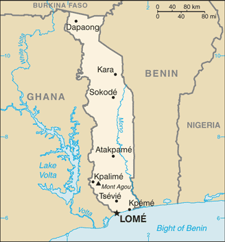
| Administrative divisions: | 5 regions (regions , singular - region); Centrale , Kara , Maritime , Plateaux , Savanes |
| Area: | total: 56 ,785 sq km land: 54 ,385 sq km water: 2 ,400 sq km |
| Background: | French Togoland became Togo in 1960. Gen. Gnassingbe EYADEMA , installed as military ruler in 1967 , ruled Togo with a heavy hand for almost four decades. Despite the facade of multiparty elections instituted in the early 1990s , the government was largely dominated by President EYADEMA , whose Rally of the Togolese People (RPT) party has maintained power almost continually since 1967 and maintains a majority of seats in today's legislature. Upon EYADEMA's death in February 2005 , the military installed the president's son , Faure GNASSINGBE , and then engineered his formal election two months later. Democratic gains since then allowed Togo to hold its first relatively free and fair legislative elections in October 2007. After years of political unrest and fire from international organizations for human rights abuses , Togo is finally being re-welcomed into the international community. |
| Flag description: | five equal horizontal bands of green (top and bottom) alternating with yellow; a white five-pointed star on a red square is in the upper hoist-side corner; uses the popular pan-African colors of Ethiopia |
| Capital: | name: Lome geographic coordinates: 6 08 N , 1 13 E time difference: UTC 0 (5 hours ahead of Washington , DC during Standard Time) |
| Climate: | tropical; hot , humid in south; semiarid in north |
| Currency code: | |
| Ethnic groups: | African (37 tribes; largest and most important are Ewe , Mina , and Kabre) 99% , European and Syrian-Lebanese less than 1% |
| Geographic coordinates: | 8 00 N , 1 10 E |
| Geography note: | the country's length allows it to stretch through six distinct geographic regions; climate varies from tropical to savanna |
| Government type: | republic under transition to multiparty democratic rule |
| Imports partners: | China 36.9% , Estonia 9.7% , Netherlands 7.9% , US 7.7% , France 7.1% (2007) |
| Internet country code: | .tg |
| Land boundaries: | 56 km |
| Neighbouring countries: | total: 1 ,647 km border countries: Benin 644 km , Burkina Faso 126 km , Ghana 877 km |
| Languages: | French (official and the language of commerce) , Ewe and Mina (the two major African languages in the south) , Kabye (sometimes spelled Kabiye) and Dagomba (the two major African languages in the north) |
| Location: | Western Africa , bordering the Bight of Benin , between Benin and Ghana |
| Map references: | Africa |
| National holiday: | Independence Day , 27 April (1960) |
| Nationality: | noun: Togolese (singular and plural) adjective: Togolese |
| Natural hazards: | hot , dry harmattan wind can reduce visibility in north during winter; periodic droughts |
| Population: | 5 ,858 ,673 note: estimates for this country explicitly take into account the effects of excess mortality due to AIDS; this can result in lower life expectancy , higher infant mortality , higher death rates , lower population growth rates , and changes in the distribution of population by age and sex than would otherwise be expected (July 2008 est.) |
| Religions: | Christian 29% , Muslim 20% , indigenous beliefs 51% |
| Terrain: | gently rolling savanna in north; central hills; southern plateau; low coastal plain with extensive lagoons and marshes |
| Unemployment rate: | NA% |
Capital of Togolese Republic
Lomé (click to view Lomé map)
Places in Togo
Browse the most comprehensive and up-to-date online directory of administrative regions and Street Views in Togo. Our listings are organized alphabetically, starting from level 1 regions and progressing through to level 2 and eventually level 3 regions, ensuring you can easily navigate and find specific areas of interest.
Afem city Google map
Afitialakofé city Google map
Agbandaodé city Google map
Agbanjaladé city Google map
Agbatopé city Google map
Agbéninou city Google map
Agnikoé city Google map
Agoudévé city Google map
Aguidagbadé city Google map
Akpakikopé city Google map
Alédjo Kadara city Google map
Aléhéridé city Google map
Amaïdé city Google map
Amaoudè city Google map
Assouma Kédémé city Google map
Até city Google map
Atimé city Google map
Atimédé city Google map
Avadadé city Google map
Avalao city Google map
Ayandété city Google map
Azaza city Google map
Bafilo city Google map
Bangan city Google map
Bassé Adjido city Google map
Bassé Djigbé city Google map
Bassé Gnamassi city Google map
Bénata city Google map
Bibindo city Google map
Birini city Google map
Blitta city Google map
Bogokopé city Google map
Bokokopé city Google map
Bongoulou city Google map
Boufouli Boko Losso city Google map
Bouhori city Google map
Boumbéri city Google map
Centrale Region (199 google map locations)
Chalandé city Google map
Chapouko city Google map
Dantcho city Google map
Démé city Google map
Dévé city Google map
Djakpo city Google map
Djena city Google map
Djirekpon city Google map
Djoukoudaou city Google map
Doubouranda city Google map
Doukorodé city Google map
Dubouidé city Google map
Éssoun city Google map
Folo city Google map
Foulenda city Google map
Gamé city Google map
Gbébaré city Google map
Glito city Google map
Goné city Google map
Gonnété city Google map
Havé city Google map
Houdikoukopé city Google map
Illigo city Google map
Itokoubé city Google map
Itounou city Google map
Jélifa city Google map
Kagnelo city Google map
Kankangbé city Google map
Katiao city Google map
Kazakalé city Google map
Kazalé city Google map
Kévèna city Google map
Kokoukopé city Google map
Kondala city Google map
Kouéda city Google map
Kouilo city Google map
Kouloumi city Google map
Koumongou city Google map
Kountonri city Google map
Kountouri city Google map
Koutiona city Google map
Kouvé city Google map
Kpoyikofé city Google map
Lavouékopé city Google map
Letsoukopé city Google map
Maritime Region (1191 google map locations)
Massouékopé city Google map
Nadoba city Google map
Nafou city Google map
Namouté city Google map
Nandri city Google map
Nuhundo city Google map
Nyigbé city Google map
Nyitoé-Zoukpé city Google map
Ofé city Google map
Ogobé city Google map
Ogodji city Google map
Ohouritcho city Google map
Okouati city Google map
Ouali city Google map
Ouorouo city Google map
Outisibé city Google map
Ouyou city Google map
Panga city Google map
Paratao city Google map
Pasa city Google map
Patala city Google map
Payambou city Google map
Plateaux Region (1125 google map locations)
Région de la Kara (673 google map locations)
Sahéringabé city Google map
Salimdé city Google map
Savanes Region (551 google map locations)
Séboukoualé city Google map
Ségbégouni city Google map
Ségoédé city Google map
Soudou city Google map
Soussoubandé city Google map
Souté city Google map
Taguégankopé city Google map
Takpamba city Google map
Tankpapiéni city Google map
Tassi city Google map
Tchamba city Google map
Tchaoro city Google map
Tchapossi city Google map
Tchapritchapra city Google map
Tchavadé city Google map
Tchékpo Dévé city Google map
Tchintchingou city Google map
Tiodiga city Google map
Tiofolèmpo city Google map
Todomé city Google map
Togourka city Google map
Toïgbo city Google map
Tomégbé city Google map
Torégadé city Google map
Tsétsé Kopé city Google map
Wasséra Kadéro city Google map
Yadé city Google map
Yégué city Google map
Random cities in Togo
Lomé, the capital city of Togo.Kokoukopé
Koundjoaré
Koutiopokopé
Kodzovya
Amoukondji
Adékplovi
Kouangan
Makou
Alakopé
Takpapié
Wodou
Nagbéni Tchokossisse
Ebéva
Konouga
Tchékpo Dévé
Agbanati
Agou Gadzépé
Kodji Tsévié
Rhébwidomé
Link to Togo Google Maps page
The map of Togo has already attracted 3740 views. If you wish to embed our comprehensive Togo map on your site, we offer an easy solution. This map includes free access to Google Maps, gazetteer search, detailed country and city maps, Street View, and essential facts, all ready to enhance your website. To use it, simply copy and paste the provided HTML code into your webpage's source code. We appreciate every link back to our Maps and Driving Directions. Thank you for your support!
| Text link to: Togo map and facts page |
This Togo map is intended solely for informational purposes. No representations or warranties are made concerning its accuracy or reliability. Users assume all risks associated with the use of Google Maps and Google Driving Directions. World Route Planner is not liable for any losses or delays that may occur from using this free Togo map.