 Republic of Iraq Google Maps and facts
Welcome to Google Maps of Iraq (IQ) and locations list of this country. World Route Planner and its detailed Iraq page is the place where Google Maps Sightseeing make sense! With comprehensive destination gazetteer, Driving Directions to Iraq, World Route Planner enables you to explore Iraq through detailed Satellite Imagery and Street View - fast, free and easy as never before. Browse the list of administrative regions below of Iraq, follow the navigation through administrative regions to find a place you are interested in and Book your hotel with Best Price Guarantee! Your Iraq Google Satellite Map Sightseeing and Street View start here.
To activate Street View on any city of Iraq, drag above the Zoom feature the yellow little man in the map.
Why is Iraq considered so rich inhistory?
Iraq is the home of one of the earliest of civilizations. Modern Iraq was Ancient Mesopotamia, from the Greek word meaning "between two rivers". It was here that human beings first began to cultivate their land, where writing was invented, and where the Assyrians, Sumerians, and Babylonians all made Iraq the centre of the ancient world. The country remains rich with a glorious past, but recent history has dealt less kindly with Iraq. Indeed, in recent years, few countries have experienced such external interference as Iraq has, culminating in the 2003 American-led invasion of the country. Sadam Hussein, ruler of Iraq was overthrown and later killed. Iraq is a land of deserts and mountains, and at its heart is its capital city of Baghdad. Today, Iraq has oil and and sugar refineries. Its economy is built on its oil reserves, which have also been the cause of much strife and turbulence.Did you know about Iraq?
Did you know that Iraq was once a part of India? During World War I, Iraq came under the British rule. India was also under the British. After the war, an international organization called the "League of Nations" was formed. Iraq came under its rule. Britain undertook the administration of Iraq for the League of Nations, through the Bombay administration. Iraq was then a part of the Bombay State - from 1920 to 1932.Facts about Iraq
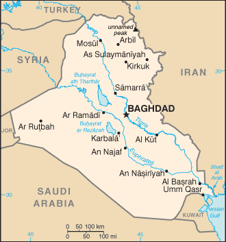
| Administrative divisions: | 18 governorates (muhafazat , singular - muhafazah) and 1 region*; Al Anbar , Al Basrah , Al Muthanna , Al Qadisiyah , An Najaf , Arbil , As Sulaymaniyah , At Ta'mim , Babil , Baghdad , Dahuk , Dhi Qar , Diyala , Karbala' , Kurdistan Regional Government* , Maysan , Ninawa , Salah ad Din , Wasit |
| Area: | total: 437 ,072 sq km land: 432 ,162 sq km water: 4 ,910 sq km |
| Background: | Formerly part of the Ottoman Empire , Iraq was occupied by Britain during the course of World War I; in 1920 , it was declared a League of Nations mandate under UK administration. In stages over the next dozen years , Iraq attained its independence as a kingdom in 1932. A "republic" was proclaimed in 1958 , but in actuality a series of military strongmen ruled the country until 2003. The last was SADDAM Husayn. Territorial disputes with Iran led to an inconclusive and costly eight-year war (1980-88). In August 1990 , Iraq seized Kuwait but was expelled by US-led , UN coalition forces during the Gulf War of January-February 1991. Following Kuwait's liberation , the UN Security Council (UNSC) required Iraq to scrap all weapons of mass destruction and long-range missiles and to allow UN verification inspections. Continued Iraqi noncompliance with UNSC resolutions over a period of 12 years led to the US-led invasion of Iraq in March 2003 and the ouster of the SADDAM Husayn regime. Coalition forces remain in Iraq under a UNSC mandate , helping to provide security and to support the freely elected government. The Coalition Provisional Authority , which temporarily administered Iraq after the invasion , transferred full governmental authority on 28 June 2004 to the Iraqi Interim Government , which governed under the Transitional Administrative Law for Iraq (TAL). Under the TAL , elections for a 275-member Transitional National Assembly (TNA) were held in Iraq on 30 January 2005. Following these elections , the Iraqi Transitional Government (ITG) assumed office. The TNA was charged with drafting Iraq's permanent constitution , which was approved in a 15 October 2005 constitutional referendum. An election under the constitution for a 275-member Council of Representatives (CoR) was held on 15 December 2005. The CoR approval in the selection of most of the cabinet ministers on 20 May 2006 marked the transition from the ITG to Iraq's first constitutional government in nearly a half-century. |
| Flag description: | three equal horizontal bands of red (top) , white , and black; the Takbir (Arabic expression meaning "God is great") in green Arabic script is centered in the white band; similar to the flag of Syria , which has two stars but no script , Yemen , which has a plain white band , and that of Egypt , which has a gold Eagle of Saladin centered in the white band; design is based upon the Arab Liberation colors; Council of Representatives approved this flag as a compromise temporary replacement for Ba'athist Saddam-era flag |
| Capital: | name: Baghdad geographic coordinates: 33 20 N , 44 23 E time difference: UTC+3 (8 hours ahead of Washington , DC during Standard Time) daylight saving time: +1hr , begins 1 April; ends 1 October |
| Climate: | mostly desert; mild to cool winters with dry , hot , cloudless summers; northern mountainous regions along Iranian and Turkish borders experience cold winters with occasionally heavy snows that melt in early spring , sometimes causing extensive flooding in central and southern Iraq |
| Currency code: | New Iraqi dinar (NID) as of 22 January 2004 |
| Ethnic groups: | Arab 75%-80% , Kurdish 15%-20% , Turkoman , Assyrian , or other 5% |
| Geographic coordinates: | 33 00 N , 44 00 E |
| Geography note: | strategic location on Shatt al Arab waterway and at the head of the Persian Gulf |
| Government type: | parliamentary democracy |
| Imports partners: | Syria 29.9% , Turkey 19.3% , US 10.8% , Jordan 4.9% , China 4.7% (2007) |
| Internet country code: | .iq |
| Land boundaries: | 58 km |
| Neighbouring countries: | total: 3 ,650 km border countries: Iran 1 ,458 km , Jordan 181 km , Kuwait 240 km , Saudi Arabia 814 km , Syria 605 km , Turkey 352 km |
| Languages: | Arabic , Kurdish (official in Kurdish regions) , Turkoman (a Turkish dialect) , Assyrian (Neo-Aramaic) , Armenian |
| Location: | Middle East , bordering the Persian Gulf , between Iran and Kuwait |
| Map references: | Middle East |
| National holiday: | Revolution Day , 17 July (1968); note - this holiday was celebrated under the SADDAM Husayn regime; the Government of Iraq has yet to declare a new national holiday |
| Nationality: | noun: Iraqi(s) adjective: Iraqi |
| Natural hazards: | dust storms , sandstorms , floods |
| Population: | 28 ,221 ,180 (July 2008 est.) |
| Religions: | Muslim 97% (Shia 60%-65% , Sunni 32%-37%) , Christian or other 3% |
| Terrain: | mostly broad plains; reedy marshes along Iranian border in south with large flooded areas; mountains along borders with Iran and Turkey |
| Unemployment rate: | 18% to 30% (2006 est.) |
Capital of Republic of Iraq
Baghdād (click to view Baghdād map)
Places in Iraq
Browse the most comprehensive and up-to-date online directory of administrative regions and Street views in Iraq. Regions are sorted in alphabetical order from level 1 to level 2 and eventually up to level 3 regions.
Al Muthanna Governorate (121 google map locations)
Al-Qadisiyyah Governorate (297 google map locations)
Arbil Governorate (764 google map locations)
As Sulaymaniyah Governorate (1292 google map locations)
Babil Governorate (582 google map locations)
Baghdad Governorate (272 google map locations)
Basra Governorate (335 google map locations)
Dahuk Governorate (518 google map locations)
Diyala Governorate (833 google map locations)
Karbala Governorate (112 google map locations)
Kirkuk Governorate (325 google map locations)
Maysan Governorate (418 google map locations)
Najaf Governorate (103 google map locations)
Ninawa Governorate (626 google map locations)
Salah ad Din Governorate (348 google map locations)
Wasit Governorate (220 google map locations)
Random cities in Iraq
Baghdād, the capital city of Iraq.Ālbū Fāris
Qal`at Salmān Mūsá
Faqē Muşţafá
Abū `Awdah
Yūsuf `Abd Allāh
Dīwān
Chamarga
Mullā `Abbūd
`Uwayjah
Kalakchī
Zināwah Ghāzī
Dūkarō
Chāft al `Āsha
Chami Korak
Na`īm al Ḩassūn
Muḩammad al Ya`qūb
Ţāhir `Abd `Alī
Minţaqat Albū Ḩinnah
Āvrīva
This Iraq map is for informational use only. No representation is made or warranty given as to its content. User assumes all risk of using Google Maps and Google Driving Directions. World Route Planner assumes no responsibility for any loss or delay resulting from such use of free Iraq map.
Link to Iraq Google Maps page
This map of Iraq has been viewed 4816 times until now. In case you would like, there is a very easy way how to link to our Iraq map - including free Google Maps, gazetteer search, country, city maps, Street View and facts -, ready to use on your website. Please, simply copy & paste the provided HTML code into your page source code: Thank you for all links to our Maps and Driving Directions!
| Text link to: Iraq map |