 State of Israel Google Maps and Facts
Welcome to the Google Maps of Israel (IL) and the comprehensive location list for this country. World Route Planner, together with its detailed Israel page, turns Google Maps Sightseeing into a meaningful experience! Our extensive destination gazetteer, coupled with Driving Directions to Israel, allows you to explore Israel through detailed satellite imagery and street views—fast, free, and easier than ever before.
Browse through the list of administrative regions in Israel, navigate through these regions to find a place of interest, and book your hotel with the Best Price Guarantee! Your journey through Israel via Google Satellite Map Sightseeing and Street View starts here.
Israel Google Maps
To activate Street View on any city of Israel, drag above the Zoom feature the yellow little man in the map.
Why do Jews evewhere consider Israel their home?
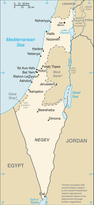
The state of Israel was formed in 1948, as a Jewish state and a democratic republic. Its borders in the West are the Mediterranean Sea and the Gaza Strip, while in the North, its borders are Lebanon and Syria. Jordan and the Palestinian Authority's autonomous territories lie to the East, and in the South, lie Egypt and the Red Sea. Israel is a land of deserts, mountains, plains and beaches. Jews all over the world consider Israel their home. Israel is part of a historicland called Palestine, where a Hebrew kingdom was established in 1000 BC. Palestine was later split into the kingdoms of Judah and Israel, which were subsequently invaded by the Assyrians, Babylonians, Egyptians, Persians, Romans, and Alexander the Great. For a Jew, Israel is more than a place - it is their Holy Land, where their history began. For over 2000 years, the Jews were exiled from this sacred land of theirs, and persecuted, and it was only after World War II ended, that they were able to return home to Israel.Facts about Israel
| Administrative divisions: | 6 districts (mehozot , singular - mehoz); Central , Haifa , Jerusalem , Northern , Southern , Tel Aviv |
| Area: | total: 20 ,770 sq km land: 20 ,330 sq km water: 440 sq km |
| Background: | Following World War II , the British withdrew from their mandate of Palestine , and the UN partitioned the area into Arab and Jewish states , an arrangement rejected by the Arabs. Subsequently , the Israelis defeated the Arabs in a series of wars without ending the deep tensions between the two sides. The territories Israel occupied since the 1967 war are not included in the Israel country profile , unless otherwise noted. On 25 April 1982 , Israel withdrew from the Sinai pursuant to the 1979 Israel-Egypt Peace Treaty. In keeping with the framework established at the Madrid Conference in October 1991 , bilateral negotiations were conducted between Israel and Palestinian representatives and Syria to achieve a permanent settlement. Israel and Palestinian officials signed on 13 September 1993 a Declaration of Principles (also known as the "Oslo Accords") guiding an interim period of Palestinian self-rule. Outstanding territorial and other disputes with Jordan were resolved in the 26 October 1994 Israel-Jordan Treaty of Peace. In addition , on 25 May 2000 , Israel withdrew unilaterally from southern Lebanon , which it had occupied since 1982. In April 2003 , US President BUSH , working in conjunction with the EU , UN , and Russia - the "Quartet" - took the lead in laying out a roadmap to a final settlement of the conflict by 2005 , based on reciprocal steps by the two parties leading to two states , Israel and a democratic Palestine. However , progress toward a permanent status agreement was undermined by Israeli-Palestinian violence between September 2003 and February 2005. An Israeli-Palestinian agreement reached at Sharm al-Sheikh in February 2005 , along with an internally-brokered Palestinian ceasefire , significantly reduced the violence. In the summer of 2005 , Israel unilaterally disengaged from the Gaza Strip , evacuating settlers and its military while retaining control over most points of entry into the Gaza Strip. The election of HAMAS in January 2006 to head the Palestinian Legislative Council froze relations between Israel and the Palestinian Authority (PA). Ehud OLMERT became prime minister in March 2006; following an Israeli military operation in Gaza in June-July 2006 and a 34-day conflict with Hizballah in Lebanon in June-August 2006 , he shelved plans to unilaterally evacuate from most of the West Bank. OLMERT in June 2007 resumed talks with the PA after HAMAS seized control of the Gaza Strip and PA President Mahmoud ABBAS formed a new government without HAMAS. |
| Flag description: | white with a blue hexagram (six-pointed linear star) known as the Magen David (Shield of David) centered between two equal horizontal blue bands near the top and bottom edges of the flag |
| Capital: | name: Jerusalem geographic coordinates: 31 46 N , 35 14 E time difference: UTC+2 (7 hours ahead of Washington , DC during Standard Time) daylight saving time: +1hr , begins last Friday in March; ends the Sunday between the holidays of Rosh Hashana and Yom Kippur note: Israel proclaimed Jerusalem as its capital in 1950 , but the US , like nearly all other countries , maintains its Embassy in Tel Aviv |
| Climate: | temperate; hot and dry in southern and eastern desert areas |
| Currency code: | new Israeli shekel (ILS); note - NIS is the currency abbreviation; ILS is the International Organization for Standardization (ISO) code for the NIS |
| Ethnic groups: | Jewish 76.4% (of which Israel-born 67.1% , Europe/America-born 22.6% , Africa-born 5.9% , Asia-born 4.2%) , non-Jewish 23.6% (mostly Arab) (2004) |
| Geographic coordinates: | 31 30 N , 34 45 E |
| Geography note: | there are about 340 Israeli civilian sites - including 100 small outpost communities in the West Bank - as well as 42 sites in the Golan Heights , 0 in the Gaza Strip , and 29 in East Jerusalem (July 2008 est.); Lake Tiberias (Sea of Galilee) is an important freshwater source |
| Government type: | parliamentary democracy |
| Imports partners: | US 13.9% , Belgium 7.9% , Germany 6.2% , China 6.1% , Switzerland 5.1% , UK 4.7% , Italy 4.1% (2007) |
| Internet country code: | .il |
| Land boundaries: | 273 km |
| Neighbouring countries: | total: 1 ,017 km border countries: Egypt 266 km , Gaza Strip 51 km , Jordan 238 km , Lebanon 79 km , Syria 76 km , West Bank 307 km |
| Languages: | Hebrew (official) , Arabic used officially for Arab minority , English most commonly used foreign language |
| Location: | Middle East , bordering the Mediterranean Sea , between Egypt and Lebanon |
| Map references: | Middle East |
| National holiday: | Independence Day , 14 May (1948); note - Israel declared independence on 14 May 1948 , but the Jewish calendar is lunar and the holiday may occur in April or May |
| Nationality: | noun: Israeli(s) adjective: Israeli |
| Natural hazards: | sandstorms may occur during spring and summer; droughts; periodic earthquakes |
| Population: | 7 ,112 ,359 note: includes about 187 ,000 Israeli settlers in the West Bank , about 20 ,000 in the Israeli-occupied Golan Heights , and fewer than 177 ,000 in East Jerusalem (July 2008 est.) |
| Religions: | Jewish 76.4% , Muslim 16% , Arab Christians 1.7% , other Christian 0.4% , Druze 1.6% , unspecified 3.9% (2004) |
| Terrain: | Negev desert in the south; low coastal plain; central mountains; Jordan Rift Valley |
| Unemployment rate: | 7.3% (2007 est.) |
Capital of State of Israel
[PLACE_CAPITAL] (click to view [PLACE_CAPITAL] map)
Places in Israel
Browse the most comprehensive and up-to-date online directory of administrative regions and Street Views in Israel. Our listings are organized alphabetically, starting from level 1 regions and progressing through to level 2 and eventually level 3 regions, ensuring you can easily navigate and find specific areas of interest.
Bīr el Maksūr city Google map
Central District (280 google map locations)
El Muṣrāra city Google map
Gadot city Google map
Ge'ullim city Google map
Giv`at Mordekhay city Google map
Haifa District (134 google map locations)
Jerusalem District (87 google map locations)
Meqor H̱ayyim city Google map
Mevo Modi`im city Google map
Naẖal Malkishua` city Google map
Northern District (383 google map locations)
Qiryat Menaẖem city Google map
Ramat Eliyyahu city Google map
Ramat Eshkol city Google map
Sanhedriyya Murẖevet city Google map
Southern District (235 google map locations)
Tel Aviv District (61 google map locations)
Yoqne`am `Illit city Google map
Random cities in Israel
[PLACE_CAPITAL], the capital city of Israel.Yas`ur
Meqor H̱ayyim
Bet HaGaddi
Tel Asher
Kefar Brandeis
Nurit
Naẖal Ya`alon
Bet Neqofa
Gadish
Ashmura
Kefar Gevirol
`Enat
Or HaNer
Peduyim
Kefar Shalem
Sha`ar Menashe
H̱uqoq
`Oẕem
Qedma
Link to Israel Google Maps page
The map of Israel has already attracted 8360 views. If you wish to embed our comprehensive Israel map on your site, we offer an easy solution. This map includes free access to Google Maps, gazetteer search, detailed country and city maps, Street View, and essential facts, all ready to enhance your website. To use it, simply copy and paste the provided HTML code into your webpage's source code. We appreciate every link back to our Maps and Driving Directions. Thank you for your support!
| Text link to: Israel map and facts page |
This Israel map is intended solely for informational purposes. No representations or warranties are made concerning its accuracy or reliability. Users assume all risks associated with the use of Google Maps and Google Driving Directions. World Route Planner is not liable for any losses or delays that may occur from using this free Israel map.