 Democratic People's Republic of Korea Google Maps and Facts
Welcome to the Google Maps of North Korea (KP) and the comprehensive location list for this country. World Route Planner, together with its detailed North Korea page, turns Google Maps Sightseeing into a meaningful experience! Our extensive destination gazetteer, coupled with Driving Directions to North Korea, allows you to explore North Korea through detailed satellite imagery and street views—fast, free, and easier than ever before.
Browse through the list of administrative regions in North Korea, navigate through these regions to find a place of interest, and book your hotel with the Best Price Guarantee! Your journey through North Korea via Google Satellite Map Sightseeing and Street View starts here.
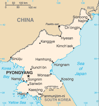
North Korea Google Maps
To activate Street View on any city of North Korea, drag above the Zoom feature the yellow little man in the map.
Why was Korea divided?
Korea is an East Asian country that is at present divided into two countries - North Korea and South Korea. But why did this division take place? The Soviet Union occupied the northern half of Korea after World War II ended in 1945. At the same time, Southern Korea was controlled by the United States. The peninsula was formally split in two in 1948. The political differences between the two rival states led to the outbreak of a horrific war in 1950. Three years later, a cease-fire agreement ended the Korean War. Butthe North Koreans and South Koreans have to this day, never signed a peace treaty. South Korea has developed into one of Asia's most affluent countries since partition in 1948. North Korea, on the other hand, has been one of the world's most secretive societies. It is one of the few countries still under nominally communist rule.Facts about North Korea
| Administrative divisions: | 9 provinces (do , singular and plural) and 4 municipalities (si , singular and plural) provinces: Chagang-do (Chagang) , Hamgyong-bukto (North Hamgyong) , Hamgyong-namdo (South Hamgyong) , Hwanghae-bukto (North Hwanghae) , Hwanghae-namdo (South Hwanghae) , Kangwon-do (Kangwon) , P'yongan-bukto (North P'yongan) , P'yongan-namdo (South P'yongan) , Yanggang-do (Yanggang) municipalities: Kaesong-si (Kaesong) , Najin Sonbong-si (Najin-Sonbong) , Namp'o-si (Namp'o) , P'yongyang-si (Pyongyang) |
| Area: | total: 120 ,540 sq km land: 120 ,410 sq km water: 130 sq km |
| Background: | An independent kingdom for much of its long history , Korea was occupied by Japan in 1905 following the Russo-Japanese War. Five years later , Japan formally annexed the entire peninsula. Following World War II , Korea was split with the northern half coming under Soviet-sponsored Communist domination. After failing in the Korean War (1950-53) to conquer the US-backed Republic of Korea (ROK) in the southern portion by force , North Korea (DPRK) , under its founder President KIM Il Sung , adopted a policy of ostensible diplomatic and economic "self-reliance" as a check against excessive Soviet or Communist Chinese influence. The DPRK demonized the US as the ultimate threat to its social system through state-funded propaganda , and molded political , economic , and military policies around the core ideological objective of eventual unification of Korea under Pyongyang's control. KIM's son , the current ruler KIM Jong Il , was officially designated as his father's successor in 1980 , assuming a growing political and managerial role until the elder KIM's death in 1994. After decades of economic mismanagement and resource misallocation , the DPRK since the mid-1990s has relied heavily on international aid to feed its population while continuing to expend resources to maintain an army of approximately 1 million. North Korea's history of regional military provocations , proliferation of military-related items , and long-range missile development - as well as its nuclear , chemical , and biological weapons programs and massive conventional armed forces - are of major concern to the international community. In December 2002 , following revelations that the DPRK was pursuing a nuclear weapons program based on enriched uranium in violation of a 1994 agreement with the US to freeze and ultimately dismantle its existing plutonium-based program , North Korea expelled monitors from the International Atomic Energy Agency (IAEA). In January 2003 , it declared its withdrawal from the international Non-Proliferation Treaty. In mid-2003 Pyongyang announced it had completed the reprocessing of spent nuclear fuel rods (to extract weapons-grade plutonium) and was developing a "nuclear deterrent." Beginning in August 2003 , North Korea , China , Japan , Russia , South Korea , and the US have participated in the Six-Party Talks aimed at resolving the stalemate over the DPRK's nuclear programs. North Korea pulled out of the talks in November 2005. It test-fired ballistic missiles in July 2006 and conducted a nuclear test in October 2006. North Korea returned to the Six-Party Talks in December 2006 and subsequently signed two agreements on denuclearization. The 13 February 2007 Initial Actions Agreement shut down the North's nuclear facilities at Yongbyon in July 2007. In the 3 October 2007 Second Phase Actions Agreement , Pyongyang pledged to disable those facilities and provide a correct and complete declaration of its nuclear programs. Under the supervision of US nuclear experts , North Korean personnel completed a number of agreed-upon disablement actions at the three core facilities at the Yongbyon nuclear complex by the end of 2007. North Korea also began the discharge of spent fuel rods in December 2007 , but it did not provide a declaration of its nuclear programs by the end of the year. |
| Flag description: | three horizontal bands of blue (top) , red (triple width) , and blue; the red band is edged in white; on the hoist side of the red band is a white disk with a red five-pointed star |
| Capital: | name: Pyongyang geographic coordinates: 39 01 N , 125 45 E time difference: UTC+9 (14 hours ahead of Washington , DC during Standard Time) |
| Climate: | temperate with rainfall concentrated in summer |
| Currency code: | North Korean won (KPW) |
| Ethnic groups: | racially homogeneous; there is a small Chinese community and a few ethnic Japanese |
| Geographic coordinates: | 40 00 N , 127 00 E |
| Geography note: | strategic location bordering China , South Korea , and Russia; mountainous interior is isolated and sparsely populated |
| Government type: | Communist state one-man dictatorship |
| Imports partners: | China 43.6% , Algeria 11.9% , Russia 7.1% , Thailand 5.6% , South Africa 4.3% (2006) |
| Internet country code: | .kp |
| Land boundaries: | 2 ,495 km |
| Neighbouring countries: | total: 1 ,673 km border countries: China 1 ,416 km , South Korea 238 km , Russia 19 km |
| Languages: | Korean |
| Location: | Eastern Asia , northern half of the Korean Peninsula bordering the Korea Bay and the Sea of Japan , between China and South Korea |
| Map references: | Asia |
| National holiday: | Founding of the Democratic People's Republic of Korea (DPRK) , 9 September (1948) |
| Nationality: | noun: Korean(s) adjective: Korean |
| Natural hazards: | late spring droughts often followed by severe flooding; occasional typhoons during the early fall |
| Population: | 23 ,479 ,088 (July 2008 est.) |
| Religions: | traditionally Buddhist and Confucianist , some Christian and syncretic Chondogyo (Religion of the Heavenly Way) note: autonomous religious activities now almost nonexistent; government-sponsored religious groups exist to provide illusion of religious freedom |
| Terrain: | mostly hills and mountains separated by deep , narrow valleys; coastal plains wide in west , discontinuous in east |
| Unemployment rate: | NA% |
Capital of Democratic People's Republic of Korea
P'yŏngyang (click to view P'yŏngyang map)
Places in North Korea
Browse the most comprehensive and up-to-date online directory of administrative regions and Street Views in North Korea. Our listings are organized alphabetically, starting from level 1 regions and progressing through to level 2 and eventually level 3 regions, ensuring you can easily navigate and find specific areas of interest.
Hwanghae-bukto (2603 google map locations)
Hwanghae-namdo (5373 google map locations)
Kaesŏng District (657 google map locations)
Kangwŏn-do (2345 google map locations)
Najin Sŏnbong-si (122 google map locations)
Namp'o-si (558 google map locations)
North Hamgyŏng Province (3371 google map locations)
North Heian Province (3882 google map locations)
P'yŏngyang-si (1707 google map locations)
South Hamgyŏng Province (3014 google map locations)
South Heian Province (2419 google map locations)
Yanggang-do (931 google map locations)
강경 city Google map
고보리 city Google map
문양리 city Google map
봉지동 city Google map
상계리 city Google map
서남이리 city Google map
서성리 city Google map
서송동 city Google map
서이리 city Google map
성상동 city Google map
송남리 city Google map
송삼리 city Google map
송석리 city Google map
송학리 city Google map
수원리 city Google map
신막리 city Google map
신설리 city Google map
신안동 city Google map
신정리 city Google map
신현리 city Google map
야교리 city Google map
용성리 city Google map
인곡리 city Google map
조양리 city Google map
줄흥동 city Google map
중양오리 city Google map
지동리 city Google map
큰말 city Google map
하북리 city Google map
하양오리 city Google map
Random cities in North Korea
P'yŏngyang, the capital city of North Korea.Pakkappŏmsan
명달골
상리
Sangsujŏng
Ch'adol-gol
Ch'ahyŏn
Sinjung-ni
장평
Yŏnbong-ni
Choul-li
천황리
신상리
소흥동
Saesulmak
Ch'igung-ni
Sŏlli-gol
Hwanggong-ni
Changt'o-dong
Chimak-kol
Link to North Korea Google Maps page
The map of North Korea has already attracted 4021 views. If you wish to embed our comprehensive North Korea map on your site, we offer an easy solution. This map includes free access to Google Maps, gazetteer search, detailed country and city maps, Street View, and essential facts, all ready to enhance your website. To use it, simply copy and paste the provided HTML code into your webpage's source code. We appreciate every link back to our Maps and Driving Directions. Thank you for your support!
| Text link to: North Korea map and facts page |
This North Korea map is intended solely for informational purposes. No representations or warranties are made concerning its accuracy or reliability. Users assume all risks associated with the use of Google Maps and Google Driving Directions. World Route Planner is not liable for any losses or delays that may occur from using this free North Korea map.