 Kingdom of Nepal Google Maps and Facts
Welcome to the Google Maps of Nepal (NP) and the comprehensive location list for this country. World Route Planner, together with its detailed Nepal page, turns Google Maps Sightseeing into a meaningful experience! Our extensive destination gazetteer, coupled with Driving Directions to Nepal, allows you to explore Nepal through detailed satellite imagery and street views—fast, free, and easier than ever before.
Browse through the list of administrative regions in Nepal, navigate through these regions to find a place of interest, and book your hotel with the Best Price Guarantee! Your journey through Nepal via Google Satellite Map Sightseeing and Street View starts here.
Nepal Google Maps
To activate Street View on any city of Nepal, drag above the Zoom feature the yellow little man in the map.
Why is Nepal a favourite destination for tourists?
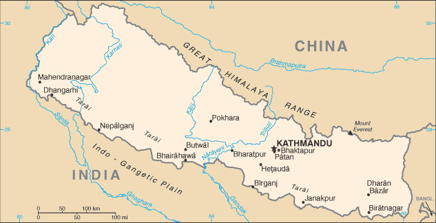
Perched on the roof of the Himalayas, Nepal shares a snowy border with China and India. A landlocked country, it had been ruled by monarchs or a ruling family for most of its modern history in relative isolation, until it became a republic in May 2008. Here, the tallest mountain in the world, Mount Everest, soars above range after range of icy peaks. It's a land of yaks and yetis, stupas and Sherpas, and some of the best trekking on Earth.Is it any wonder that Nepal is a hot favourite with tourists from all overtheworld?
The first civilizations in Nepal, which flourished around the 6th century BC, were confined to the fertile Kathmandu Valley where the present-day capital of the same name is located. It was in this region that Prince Siddhartha Gautama was born in 563 BC Gautama achieved enlightenment as Buddha, and gave riseto Buddhism. Most of the people in Nepal are farmers. Others herd sheep and yaks. However, today, tourism is the main industry.Facts about Nepal
| Administrative divisions: | 14 zones (anchal , singular and plural); Bagmati , Bheri , Dhawalagiri , Gandaki , Janakpur , Karnali , Kosi , Lumbini , Mahakali , Mechi , Narayani , Rapti , Sagarmatha , Seti |
| Area: | total: 147 ,181 sq km land: 143 ,181 sq km water: 4 ,000 sq km |
| Background: | In 1951 , the Nepalese monarch ended the century-old system of rule by hereditary premiers and instituted a cabinet system of government. Reforms in 1990 established a multiparty democracy within the framework of a constitutional monarchy. An insurgency led by Maoist extremists broke out in 1996. The ensuing nine-year civil war between insurgents and government forces witnessed the dissolution of the cabinet and parliament and assumption of absolute power by the king. Several weeks of mass protests in April 2006 were followed by several months of peace negotiations between the Maoists and government officials , and culminated in a November 2006 peace accord and the promulgation of an interim constitution. The newly formed interim parliament declared Nepal a democratic federal republic at its first meeting in May 2008 , the king vacated the throne in mid-June 2008 , and parliament elected the country's first president the following month. |
| Flag description: | red with a blue border around the unique shape of two overlapping right triangles; the smaller , upper triangle bears a white stylized moon and the larger , lower triangle bears a white 12-pointed sun |
| Capital: | name: Kathmandu geographic coordinates: 27 43 N , 85 19 E time difference: UTC+5.75 (10.75 hours ahead of Washington , DC during Standard Time) |
| Climate: | varies from cool summers and severe winters in north to subtropical summers and mild winters in south |
| Currency code: | Nepalese rupee (NPR) |
| Ethnic groups: | Chhettri 15.5% , Brahman-Hill 12.5% , Magar 7% , Tharu 6.6% , Tamang 5.5% , Newar 5.4% , Muslim 4.2% , Kami 3.9% , Yadav 3.9% , other 32.7% , unspecified 2.8% (2001 census) |
| Geographic coordinates: | 28 00 N , 84 00 E |
| Geography note: | landlocked; strategic location between China and India; contains eight of world's 10 highest peaks , including Mount Everest and Kanchenjunga - the world's tallest and third tallest - on the borders with China and India respectively |
| Government type: | democratic republic |
| Imports partners: | India 56.2% , China 13% , Indonesia 2.9% (2007) |
| Internet country code: | .np |
| Land boundaries: | 0 km (landlocked) |
| Neighbouring countries: | total: 2 ,926 km border countries: China 1 ,236 km , India 1 ,690 km |
| Languages: | Nepali 47.8% , Maithali 12.1% , Bhojpuri 7.4% , Tharu (Dagaura/Rana) 5.8% , Tamang 5.1% , Newar 3.6% , Magar 3.3% , Awadhi 2.4% , other 10% , unspecified 2.5% (2001 census) note: many in government and business also speak English (2001 est.) |
| Location: | Southern Asia , between China and India |
| Map references: | Asia |
| National holiday: | NA; note - in 2006 , Parliament abolished the birthday of King GYANENDRA (7 July) and Constitution Day (9 November) as national holidays |
| Nationality: | noun: Nepalese (singular and plural) adjective: Nepalese |
| Natural hazards: | severe thunderstorms , flooding , landslides , drought , and famine depending on the timing , intensity , and duration of the summer monsoons |
| Population: | 29 ,519 ,114 (July 2008 est.) |
| Religions: | Hindu 80.6% , Buddhist 10.7% , Muslim 4.2% , Kirant 3.6% , other 0.9% (2001 census) note: only official Hindu state in the world |
| Terrain: | Tarai or flat river plain of the Ganges in south , central hill region , rugged Himalayas in north |
| Unemployment rate: | 42% (2004 est.) |
Capital of Kingdom of Nepal
Kathmandu (click to view Kathmandu map)
Places in Nepal
Browse the most comprehensive and up-to-date online directory of administrative regions and Street Views in Nepal. Our listings are organized alphabetically, starting from level 1 regions and progressing through to level 2 and eventually level 3 regions, ensuring you can easily navigate and find specific areas of interest.
Bherī Zone city Google map
Central Region (171 google map locations)
Dhawalāgiri Zone city Google map
East Region (134 google map locations)
Gandakī Zone city Google map
Janakpur Zone city Google map
Midwest Region (180 google map locations)
West Region (176 google map locations)
Random cities in Nepal
Kathmandu, the capital city of Nepal.Ramdikbāna
Kermi
Bāndādāndi
Musīkot
Lāngtāng
Jamuna
Gularia
Upardāng Garhi
Sukhar
Phulwāriā
Umāri
Banepa
Rālnābās
Mingbo
Muglaha
Sallen
Hardia Chauki
Haraincha
Rānīpauwa
Link to Nepal Google Maps page
The map of Nepal has already attracted 7381 views. If you wish to embed our comprehensive Nepal map on your site, we offer an easy solution. This map includes free access to Google Maps, gazetteer search, detailed country and city maps, Street View, and essential facts, all ready to enhance your website. To use it, simply copy and paste the provided HTML code into your webpage's source code. We appreciate every link back to our Maps and Driving Directions. Thank you for your support!
| Text link to: Nepal map and facts page |
This Nepal map is intended solely for informational purposes. No representations or warranties are made concerning its accuracy or reliability. Users assume all risks associated with the use of Google Maps and Google Driving Directions. World Route Planner is not liable for any losses or delays that may occur from using this free Nepal map.