 Democratic Socialist Republic of Sri Lanka Google Maps and facts
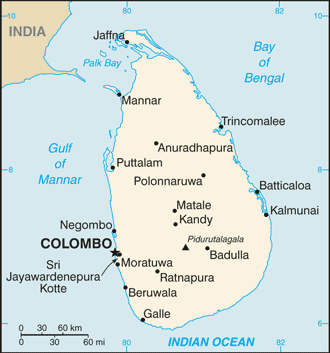
Welcome to Google Maps of Sri Lanka (LK) and locations list of this country. World Route Planner and its detailed Sri Lanka page is the place where Google Maps Sightseeing make sense! With comprehensive destination gazetteer, Driving Directions to Sri Lanka, World Route Planner enables you to explore Sri Lanka through detailed Satellite Imagery and Street View - fast, free and easy as never before. Browse the list of administrative regions below of Sri Lanka, follow the navigation through administrative regions to find a place you are interested in and Book your hotel with Best Price Guarantee! Your Sri Lanka Google Satellite Map Sightseeing and Street View start here.
To activate Street View on any city of Sri Lanka, drag above the Zoom feature the yellow little man in the map.
Why is Sri Lanka known as "the jewel box' of the Indian Ocean"?
Sri Lanka lies off the southern tip of India. This tropical island has fascinated travellers for centuries, with its palm-fringed beaches, diverse landscapes and historical monuments. Known as "Serendip" to Arab geographers, the island fell under Portuguese and Dutch influence and finally came under British rule when it was called Ceylon. The island became independent in 1948, and changed its name to Sri Lanka in 1972. Agriculture is the main occupation, and the important crops produced are tea, coconuts, rice, and rubber. Sri Lanka is also known as the jewel box of the Indian Ocean, and has yielded precious stones and fine gems in a great profusion of species and varieties. Gems from Ceylon became famous all over the world, and today there is even a town called Ratnapura or "gem town"!Facts about Sri Lanka
| Administrative divisions: | 8 provinces; Central , North Central , North Eastern , North Western , Sabaragamuwa , Southern , Uva , Western note: in October 2006 , a Sri Lankan Supreme Court ruling voided a presidential directive merging the North and Eastern Provinces; many have defended the merger as a prerequisite for a negotiated settlement to the ethnic conflict; a parliamentary decision on the issue is pending |
| Area: | total: 65 ,610 sq km land: 64 ,740 sq km water: 870 sq km |
| Background: | The first Sinhalese arrived in Sri Lanka late in the 6th century B.C. probably from northern India. Buddhism was introduced in about the mid-third century B.C. , and a great civilization developed at the cities of Anuradhapura (kingdom from circa 200 B.C. to circa A.D. 1000) and Polonnaruwa (from about 1070 to 1200). In the 14th century , a south Indian dynasty established a Tamil kingdom in northern Sri Lanka. The coastal areas of the island were controlled by the Portuguese in the 16th century and by the Dutch in the 17th century. The island was ceded to the British in 1796 , became a crown colony in 1802 , and was united under British rule by 1815. As Ceylon , it became independent in 1948; its name was changed to Sri Lanka in 1972. Tensions between the Sinhalese majority and Tamil separatists erupted into war in 1983. Tens of thousands have died in the ethnic conflict that continues to fester. After two decades of fighting , the government and Liberation Tigers of Tamil Eelam (LTTE) formalized a cease-fire in February 2002 with Norway brokering peace negotiations. Violence between the LTTE and government forces intensified in 2006 and the government regained control of the Eastern Province in 2007. In January 2008 , the government officially withdrew from the ceasefire , and has begun engaging the LTTE in the northern portion of the country. |
| Flag description: | yellow with two panels; the smaller hoist-side panel has two equal vertical bands of green (hoist side) and orange; the other panel is a large dark red rectangle with a yellow lion holding a sword , and there is a yellow bo leaf in each corner; the yellow field appears as a border around the entire flag and extends between the two panels |
| Capital: | name: Colombo geographic coordinates: 6 56 N , 79 51 E time difference: UTC+5.5 (10.5 hours ahead of Washington , DC during Standard Time) note: Sri Jayewardenepura Kotte (legislative capital) |
| Climate: | tropical monsoon; northeast monsoon (December to March); southwest monsoon (June to October) |
| Currency code: | |
| Ethnic groups: | Sinhalese 73.8% , Sri Lankan Moors 7.2% , Indian Tamil 4.6% , Sri Lankan Tamil 3.9% , other 0.5% , unspecified 10% (2001 census provisional data) |
| Geographic coordinates: | 7 00 N , 81 00 E |
| Geography note: | strategic location near major Indian Ocean sea lanes |
| Government type: | republic |
| Imports partners: | India 22% , China 11.9% , Singapore 7.2% , Iran 6.2% (2007) |
| Internet country code: | .lk |
| Land boundaries: | 1 ,340 km |
| Neighbouring countries: | 0 km |
| Languages: | Sinhala (official and national language) 74% , Tamil (national language) 18% , other 8% note: English is commonly used in government and is spoken competently by about 10% of the population |
| Location: | Southern Asia , island in the Indian Ocean , south of India |
| Map references: | Asia |
| National holiday: | Independence Day , 4 February (1948) |
| Nationality: | noun: Sri Lankan(s) adjective: Sri Lankan |
| Natural hazards: | occasional cyclones and tornadoes |
| Population: | 21 ,128 ,772 note: since the outbreak of hostilities between the government and armed Tamil separatists in the mid-1980s , several hundred thousand Tamil civilians have fled the island and more than 200 ,000 Tamils have sought refuge in the West (July 2008 est.) |
| Religions: | Buddhist 69.1% , Muslim 7.6% , Hindu 7.1% , Christian 6.2% , unspecified 10% (2001 census provisional data) |
| Terrain: | mostly low , flat to rolling plain; mountains in south-central interior |
| Unemployment rate: | 6% (2007 est.) |
Capital of Democratic Socialist Republic of Sri Lanka
Colombo (click to view Colombo map)
Places in Sri Lanka
Browse the most comprehensive and up-to-date online directory of administrative regions and Street views in Sri Lanka. Regions are sorted in alphabetical order from level 1 to level 2 and eventually up to level 3 regions.
North Central Province (1425 google map locations)
North Eastern Province (1633 google map locations)
North Western Province (3713 google map locations)
Southern Province (1756 google map locations)
Uva Province (1069 google map locations)
Western Province (1526 google map locations)
Random cities in Sri Lanka
Colombo, the capital city of Sri Lanka.Wendala
Pallehena
Duwemodera
Ihala Bakmigahaulpota
Tavadi
Kirittona
Barahelagamuwa
Namunukula
Ellagala
Dalupatgedara
Ganhata
Kahawatugoda
Pohonnaruwa Handurumulla
Palle Henepola
Mount Calvary
Huruggomuwa
Rikillagamuwa
Hitgoda Walpola
Noragalla
This Sri Lanka map is for informational use only. No representation is made or warranty given as to its content. User assumes all risk of using Google Maps and Google Driving Directions. World Route Planner assumes no responsibility for any loss or delay resulting from such use of free Sri Lanka map.
Link to Sri Lanka Google Maps page
This map of Sri Lanka has been viewed 9388 times until now. In case you would like, there is a very easy way how to link to our Sri Lanka map - including free Google Maps, gazetteer search, country, city maps, Street View and facts -, ready to use on your website. Please, simply copy & paste the provided HTML code into your page source code: Thank you for all links to our Maps and Driving Directions!
| Text link to: Sri Lanka map |