 Barbados Google Maps and Facts
Welcome to the Google Maps of Barbados (BB) and the comprehensive location list for this country. World Route Planner, together with its detailed Barbados page, turns Google Maps Sightseeing into a meaningful experience! Our extensive destination gazetteer, coupled with Driving Directions to Barbados, allows you to explore Barbados through detailed satellite imagery and street views—fast, free, and easier than ever before.
Browse through the list of administrative regions in Barbados, navigate through these regions to find a place of interest, and book your hotel with the Best Price Guarantee! Your journey through Barbados via Google Satellite Map Sightseeing and Street View starts here.
Barbados Google Maps
To activate Street View on any city of Barbados, drag above the Zoom feature the yellow little man in the map.
Facts about Barbados
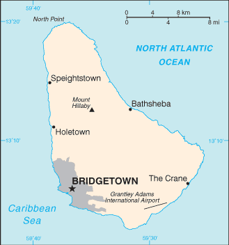
| Administrative divisions: | 11 parishes and 1 city*; Bridgetown* , Christ Church , Saint Andrew , Saint George , Saint James , Saint John , Saint Joseph , Saint Lucy , Saint Michael , Saint Peter , Saint Philip , Saint Thomas |
| Area: | total: 431 sq km land: 431 sq km water: 0 sq km |
| Background: | The island was uninhabited when first settled by the British in 1627. Slaves worked the sugar plantations established on the island until 1834 when slavery was abolished. The economy remained heavily dependent on sugar , rum , and molasses production through most of the 20th century. The gradual introduction of social and political reforms in the 1940s and 1950s led to complete independence from the UK in 1966. In the 1990s , tourism and manufacturing surpassed the sugar industry in economic importance. |
| Flag description: | three equal vertical bands of blue (hoist side) , gold , and blue with the head of a black trident centered on the gold band; the trident head represents independence and a break with the past (the colonial coat of arms contained a complete trident) |
| Capital: | name: Bridgetown geographic coordinates: 13 06 N , 59 37 W time difference: UTC-4 (1 hour ahead of Washington , DC during Standard Time) |
| Climate: | tropical; rainy season (June to October) |
| Currency code: | Barbadian dollar (BBD) |
| Ethnic groups: | black 90% , white 4% , Asian and mixed 6% |
| Geographic coordinates: | 13 10 N , 59 32 W |
| Geography note: | easternmost Caribbean island |
| Government type: | parliamentary democracy |
| Imports partners: | US 29.7% , Trinidad and Tobago 26.9% , UK 6.4% (2007) |
| Internet country code: | .bb |
| Land boundaries: | 97 km |
| Neighbouring countries: | 0 km |
| Languages: | English |
| Location: | Caribbean , island in the North Atlantic Ocean , northeast of Venezuela |
| Map references: | Central America and the Caribbean |
| National holiday: | Independence Day , 30 November (1966) |
| Nationality: | noun: Barbadian(s) or Bajan (colloquial) adjective: Barbadian or Bajan (colloquial) |
| Natural hazards: | infrequent hurricanes; periodic landslides |
| Population: | 281 ,968 (July 2008 est.) |
| Religions: | Protestant 63.4% (Anglican 28.3% , Pentecostal 18.7% , Methodist 5.1% , other 11.3%) , Roman Catholic 4.2% , other Christian 7% , other 4.8% , none or unspecified 20.6% (2008 est.) |
| Terrain: | relatively flat; rises gently to central highland region |
| Unemployment rate: | 10.7% (2003 est.) |
Capital of Barbados
Bridgetown (click to view Bridgetown map)
Places in Barbados
Browse the most comprehensive and up-to-date online directory of administrative regions and Street Views in Barbados. Our listings are organized alphabetically, starting from level 1 regions and progressing through to level 2 and eventually level 3 regions, ensuring you can easily navigate and find specific areas of interest.
Parish of Saint Andrew (21 google map locations)
Parish of Saint George (50 google map locations)
Parish of Saint James (36 google map locations)
Parish of Saint John (42 google map locations)
Parish of Saint Joseph (28 google map locations)
Parish of Saint Michael (45 google map locations)
Parish of Saint Peter (44 google map locations)
Parish of Saint Philip (62 google map locations)
Parish of Saint Thomas (31 google map locations)
Random cities in Barbados
Bridgetown, the capital city of Barbados.Ellerton
Top Rock
Saint Andrews
Rock Hall
Sam Lords Castle
Kingsland
Fortescue
Walronds
Blue Waters
Portland
Coach Hill
Station Hill
Moonshine Hall
Robinsons
Coles Cave
Melverton
French
Oldbury
Maycock
Link to Barbados Google Maps page
The map of Barbados has already attracted 5003 views. If you wish to embed our comprehensive Barbados map on your site, we offer an easy solution. This map includes free access to Google Maps, gazetteer search, detailed country and city maps, Street View, and essential facts, all ready to enhance your website. To use it, simply copy and paste the provided HTML code into your webpage's source code. We appreciate every link back to our Maps and Driving Directions. Thank you for your support!
| Text link to: Barbados map and facts page |
This Barbados map is intended solely for informational purposes. No representations or warranties are made concerning its accuracy or reliability. Users assume all risks associated with the use of Google Maps and Google Driving Directions. World Route Planner is not liable for any losses or delays that may occur from using this free Barbados map.