 Republic of Honduras Google Maps and Facts
Welcome to the Google Maps of Honduras (HN) and the comprehensive location list for this country. World Route Planner, together with its detailed Honduras page, turns Google Maps Sightseeing into a meaningful experience! Our extensive destination gazetteer, coupled with Driving Directions to Honduras, allows you to explore Honduras through detailed satellite imagery and street views—fast, free, and easier than ever before.
Browse through the list of administrative regions in Honduras, navigate through these regions to find a place of interest, and book your hotel with the Best Price Guarantee! Your journey through Honduras via Google Satellite Map Sightseeing and Street View starts here.
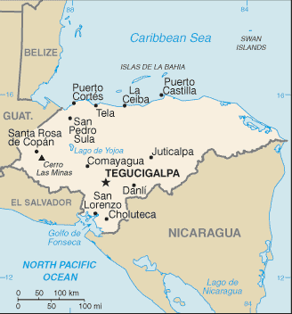
Honduras Google Maps
To activate Street View on any city of Honduras, drag above the Zoom feature the yellow little man in the map.
Facts about Honduras
| Administrative divisions: | 18 departments (departamentos , singular - departamento); Atlantida , Choluteca , Colon , Comayagua , Copan , Cortes , El Paraiso , Francisco Morazan , Gracias a Dios , Intibuca , Islas de la Bahia , La Paz , Lempira , Ocotepeque , Olancho , Santa Barbara , Valle , Yoro |
| Area: | total: 112 ,090 sq km land: 111 ,890 sq km water: 200 sq km |
| Background: | Once part of Spain's vast empire in the New World , Honduras became an independent nation in 1821. After two and a half decades of mostly military rule , a freely elected civilian government came to power in 1982. During the 1980s , Honduras proved a haven for anti-Sandinista contras fighting the Marxist Nicaraguan Government and an ally to Salvadoran Government forces fighting leftist guerrillas. The country was devastated by Hurricane Mitch in 1998 , which killed about 5 ,600 people and caused approximately $2 billion in damage. |
| Flag description: | three equal horizontal bands of blue (top) , white , and blue with five blue , five-pointed stars arranged in an X pattern centered in the white band; the stars represent the members of the former Federal Republic of Central America - Costa Rica , El Salvador , Guatemala , Honduras , and Nicaragua; similar to the flag of El Salvador , which features a round emblem encircled by the words REPUBLICA DE EL SALVADOR EN LA AMERICA CENTRAL centered in the white band; also similar to the flag of Nicaragua , which features a triangle encircled by the word REPUBLICA DE NICARAGUA on top and AMERICA CENTRAL on the bottom , centered in the white band |
| Capital: | name: Tegucigalpa geographic coordinates: 14 06 N , 87 13 W time difference: UTC-6 (1 hour behind Washington , DC during Standard Time) daylight saving time: +1hr , begins second Sunday in March; ends first Sunday in November |
| Climate: | subtropical in lowlands , temperate in mountains |
| Currency code: | lempira (HNL) |
| Ethnic groups: | mestizo (mixed Amerindian and European) 90% , Amerindian 7% , black 2% , white 1% |
| Geographic coordinates: | 15 00 N , 86 30 W |
| Geography note: | has only a short Pacific coast but a long Caribbean shoreline , including the virtually uninhabited eastern Mosquito Coast |
| Government type: | democratic constitutional republic |
| Imports partners: | US 52.2% , Guatemala 7.1% , El Salvador 4.5% , Costa Rica 4.2% , Mexico 4.1% (2007) |
| Internet country code: | .hn |
| Land boundaries: | 820 km |
| Neighbouring countries: | total: 1 ,520 km border countries: Guatemala 256 km , El Salvador 342 km , Nicaragua 922 km |
| Languages: | Spanish , Amerindian dialects |
| Location: | Central America , bordering the Caribbean Sea , between Guatemala and Nicaragua and bordering the Gulf of Fonseca (North Pacific Ocean) , between El Salvador and Nicaragua |
| Map references: | Central America and the Caribbean |
| National holiday: | Independence Day , 15 September (1821) |
| Nationality: | noun: Honduran(s) adjective: Honduran |
| Natural hazards: | frequent , but generally mild , earthquakes; extremely susceptible to damaging hurricanes and floods along the Caribbean coast |
| Population: | 7 ,639 ,327 note: estimates for this country explicitly take into account the effects of excess mortality due to AIDS; this can result in lower life expectancy , higher infant mortality , higher death rates , lower population growth rates , and changes in the distribution of population by age and sex than would otherwise be expected (July 2008 est.) |
| Religions: | Roman Catholic 97% , Protestant 3% |
| Terrain: | mostly mountains in interior , narrow coastal plains |
| Unemployment rate: | 27.8% (2007 est.) |
Capital of Republic of Honduras
Tegucigalpa (click to view Tegucigalpa map)
Places in Honduras
Browse the most comprehensive and up-to-date online directory of administrative regions and Street Views in Honduras. Our listings are organized alphabetically, starting from level 1 regions and progressing through to level 2 and eventually level 3 regions, ensuring you can easily navigate and find specific areas of interest.
Choluteca Department (1037 google map locations)
Colón Department (238 google map locations)
Comayagua Department (469 google map locations)
Copán Department (568 google map locations)
Cortés Department (442 google map locations)
El Paraíso Department (722 google map locations)
Francisco Morazán Department (1161 google map locations)
Gracias a Dios Department (247 google map locations)
Islas de la Bahía Department (60 google map locations)
La Paz Department (441 google map locations)
Lempira Department (711 google map locations)
Ocotepeque Department (243 google map locations)
Olancho Department (571 google map locations)
Santa Bárbara Department (581 google map locations)
Valle Department (502 google map locations)
Yoro Department (504 google map locations)
Random cities in Honduras
Tegucigalpa, the capital city of Honduras.Quebrada Colorada
Las Chichimoras
Limón
Concepción de Guasistagua
Campo Bálsamo
Gualán
San Jerónimo
La Cebadilla
Mata de Plátano
Protección
Playitas
Las Cureñas
Azacualpa
Mata Palo
Coyolar
Los Terreros
Taixíguat
Los Jobos
Mezcales
Link to Honduras Google Maps page
The map of Honduras has already attracted 9191 views. If you wish to embed our comprehensive Honduras map on your site, we offer an easy solution. This map includes free access to Google Maps, gazetteer search, detailed country and city maps, Street View, and essential facts, all ready to enhance your website. To use it, simply copy and paste the provided HTML code into your webpage's source code. We appreciate every link back to our Maps and Driving Directions. Thank you for your support!
| Text link to: Honduras map and facts page |
This Honduras map is intended solely for informational purposes. No representations or warranties are made concerning its accuracy or reliability. Users assume all risks associated with the use of Google Maps and Google Driving Directions. World Route Planner is not liable for any losses or delays that may occur from using this free Honduras map.