 Republic of Trinidad and Tobago Google Maps and Facts
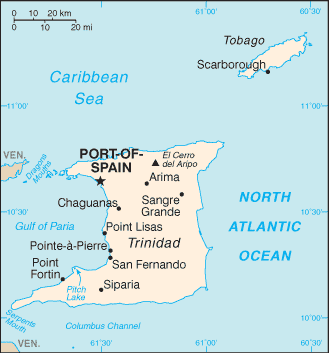
Map of Trinidad and Tobago ⇣ | Google Maps of Trinidad and Tobago ⇣ | All Places in Trinidad and Tobago ⇣
Welcome to the Google Maps of Trinidad and Tobago (TT) and the comprehensive location list for this country. World Route Planner, together with its detailed Trinidad and Tobago page, turns Google Maps Sightseeing into a meaningful experience! Our extensive destination gazetteer, coupled with Driving Directions to Trinidad and Tobago, allows you to explore Trinidad and Tobago through detailed satellite imagery and street views—fast, free, and easier than ever before.
Browse through the list of administrative regions in Trinidad and Tobago, navigate through these regions to find a place of interest, and book your hotel with the Best Price Guarantee! Your journey through Trinidad and Tobago via Google Satellite Map Sightseeing and Street View starts here.
Trinidad and Tobago Google Maps
To activate Street View on any city of Trinidad and Tobago, drag above the Zoom feature the yellow little man in the map.
Facts about Trinidad and Tobago
| Administrative divisions: | 9 regional corporations , 2 city corporations , 3 borough corporations , 1 ward regional corporations: Couva/Tabaquite/Talparo , Diego Martin , Mayaro/Rio Claro , Penal/Debe , Princes Town , Sangre Grande , San Juan/Laventille , Siparia , Tunapuna/Piarco city corporations: Port-of-Spain , San Fernando borough corporations: Arima , Chaguanas , Point Fortin ward: Tobago |
| Area: | total: 5 ,128 sq km land: 5 ,128 sq km water: 0 sq km |
| Background: | First colonized by the Spanish , the islands came under British control in the early 19th century. The islands' sugar industry was hurt by the emancipation of the slaves in 1834. Manpower was replaced with the importation of contract laborers from India between 1845 and 1917 , which boosted sugar production as well as the cocoa industry. The discovery of oil on Trinidad in 1910 added another important export. Independence was attained in 1962. The country is one of the most prosperous in the Caribbean thanks largely to petroleum and natural gas production and processing. Tourism , mostly in Tobago , is targeted for expansion and is growing. The government is coping with a rise in violent crime. |
| Flag description: | red with a white-edged black diagonal band from the upper hoist side to the lower fly side |
| Capital: | name: Port-of-Spain geographic coordinates: 10 39 N , 61 31 W time difference: UTC-4 (1 hour ahead of Washington , DC during Standard Time) |
| Climate: | tropical; rainy season (June to December) |
| Currency code: | |
| Ethnic groups: | Indian (South Asian) 40% , African 37.5% , mixed 20.5% , other 1.2% , unspecified 0.8% (2000 census) |
| Geographic coordinates: | 11 00 N , 61 00 W |
| Geography note: | Pitch Lake , on Trinidad's southwestern coast , is the world's largest natural reservoir of asphalt |
| Government type: | parliamentary democracy |
| Imports partners: | US 27.9% , Brazil 12.3% , Venezuela 8.1% , Gabon 4.9% , Colombia 4.8% , China 4.1% (2007) |
| Internet country code: | .tt |
| Land boundaries: | 362 km |
| Neighbouring countries: | 0 km |
| Languages: | English (official) , Caribbean Hindustani (a dialect of Hindi) , French , Spanish , Chinese |
| Location: | Caribbean , islands between the Caribbean Sea and the North Atlantic Ocean , northeast of Venezuela |
| Map references: | Central America and the Caribbean |
| National holiday: | Independence Day , 31 August (1962) |
| Nationality: | noun: Trinidadian(s) , Tobagonian(s) adjective: Trinidadian , Tobagonian |
| Natural hazards: | outside usual path of hurricanes and other tropical storms |
| Population: | 1 ,047 ,366 (July 2008 est.) |
| Religions: | Roman Catholic 26% , Hindu 22.5% , Anglican 7.8% , Baptist 7.2% , Pentecostal 6.8% , Muslim 5.8% , Seventh Day Adventist 4% , other Christian 5.8% , other 10.8% , unspecified 1.4% , none 1.9% (2000 census) |
| Terrain: | mostly plains with some hills and low mountains |
| Unemployment rate: | 4.5% (2007 est.) |
Capital of Republic of Trinidad and Tobago
Port-of-Spain (click to view Port-of-Spain map)
Places in Trinidad and Tobago
Browse the most comprehensive and up-to-date online directory of administrative regions and Street Views in Trinidad and Tobago. Our listings are organized alphabetically, starting from level 1 regions and progressing through to level 2 and eventually level 3 regions, ensuring you can easily navigate and find specific areas of interest.
Boissiere Village city Google map
Corbeaux Town city Google map
County of Caroni (50 google map locations)
County of Mayaro (6 google map locations)
County of Nariva (11 google map locations)
County of Saint Andrew (37 google map locations)
County of Saint David (15 google map locations)
County of Saint George (70 google map locations)
County of Saint Patrick (37 google map locations)
County of Victoria (65 google map locations)
Earthigg city Google map
La Basse city Google map
Laventille city Google map
Marabella city Google map
Mon Repos city Google map
Peru city Google map
Port-of-Spain city Google map
Saint Clair city Google map
San Fernando city Google map
Ward of Tobago (93 google map locations)
Woodbrook city Google map
Random cities in Trinidad and Tobago
Port-of-Spain, the capital city of Trinidad and Tobago.San Rafael
Guaico
Bonasse
Roxborough
Four Roads
Cipero-Sainte Croix
Vista Bella
Upper Manzanilla
Mesopotamia
Friendship
Fifth Company
Brasso
Cunapo
Lopinot
La Finette
Indian Walk
Centento
Coromandel Settlement
Mount Saint George
Link to Trinidad and Tobago Google Maps page
The map of Trinidad and Tobago has already attracted 7538 views. If you wish to embed our comprehensive Trinidad and Tobago map on your site, we offer an easy solution. This map includes free access to Google Maps, gazetteer search, detailed country and city maps, Street View, and essential facts, all ready to enhance your website. To use it, simply copy and paste the provided HTML code into your webpage's source code. We appreciate every link back to our Maps and Driving Directions. Thank you for your support!
| Text link to: Trinidad and Tobago map and facts page |
This Trinidad and Tobago map is intended solely for informational purposes. No representations or warranties are made concerning its accuracy or reliability. Users assume all risks associated with the use of Google Maps and Google Driving Directions. World Route Planner is not liable for any losses or delays that may occur from using this free Trinidad and Tobago map.