 Bosnia and Herzegovina Google Maps and Facts
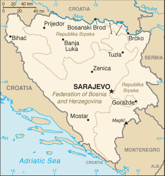
Map of Bosnia and Herzegovina ⇣ | Google Maps of Bosnia and Herzegovina ⇣ | All Places in Bosnia and Herzegovina ⇣
Welcome to the Google Maps of Bosnia and Herzegovina (BA) and the comprehensive location list for this country. World Route Planner, together with its detailed Bosnia and Herzegovina page, turns Google Maps Sightseeing into a meaningful experience! Our extensive destination gazetteer, coupled with Driving Directions to Bosnia and Herzegovina, allows you to explore Bosnia and Herzegovina through detailed satellite imagery and street views—fast, free, and easier than ever before.
Browse through the list of administrative regions in Bosnia and Herzegovina, navigate through these regions to find a place of interest, and book your hotel with the Best Price Guarantee! Your journey through Bosnia and Herzegovina via Google Satellite Map Sightseeing and Street View starts here.
Bosnia and Herzegovina Google Maps
To activate Street View on any city of Bosnia and Herzegovina, drag above the Zoom feature the yellow little man in the map.
Facts about Bosnia and Herzegovina
| Administrative divisions: | 2 first-order administrative divisions and 1 internationally supervised district* - Brcko district (Brcko Distrikt)* , the Bosniak/Croat Federation of Bosnia and Herzegovina (Federacija Bosna i Hercegovina) and the Bosnian Serb-led Republika Srpska; note - Brcko district is in northeastern Bosnia and is an administrative unit under the sovereignty of Bosnia and Herzegovina; the district remains under international supervision |
| Area: | total: 51 ,209.2 sq km land: 51 ,197 sq km water: 12.2 sq km |
| Background: | Bosnia and Herzegovina's declaration of sovereignty in October 1991 was followed by a declaration of independence from the former Yugoslavia on 3 March 1992 after a referendum boycotted by ethnic Serbs. The Bosnian Serbs - supported by neighboring Serbia and Montenegro - responded with armed resistance aimed at partitioning the republic along ethnic lines and joining Serb-held areas to form a "Greater Serbia." In March 1994 , Bosniaks and Croats reduced the number of warring factions from three to two by signing an agreement creating a joint Bosniak/Croat Federation of Bosnia and Herzegovina. On 21 November 1995 , in Dayton , Ohio , the warring parties initialed a peace agreement that brought to a halt three years of interethnic civil strife (the final agreement was signed in Paris on 14 December 1995). The Dayton Peace Accords retained Bosnia and Herzegovina's international boundaries and created a joint multi-ethnic and democratic government charged with conducting foreign , diplomatic , and fiscal policy. Also recognized was a second tier of government comprised of two entities roughly equal in size: the Bosniak/Croat Federation of Bosnia and Herzegovina and the Bosnian Serb-led Republika Srpska (RS). The Federation and RS governments were charged with overseeing most government functions. The Office of the High Representative (OHR) was established to oversee the implementation of the civilian aspects of the agreement. In 1995-96 , a NATO-led international peacekeeping force (IFOR) of 60 ,000 troops served in Bosnia to implement and monitor the military aspects of the agreement. IFOR was succeeded by a smaller , NATO-led Stabilization Force (SFOR) whose mission was to deter renewed hostilities. European Union peacekeeping troops (EUFOR) replaced SFOR in December 2004; their mission is to maintain peace and stability throughout the country. EUFOR's mission changed from peacekeeping to civil policing in October 2007 , with its presence reduced from nearly 7 ,000 to 2 ,500 troops. |
| Flag description: | a wide medium blue vertical band on the fly side with a yellow isosceles triangle abutting the band and the top of the flag; the remainder of the flag is medium blue with seven full five-pointed white stars and two half stars top and bottom along the hypotenuse of the triangle |
| Capital: | name: Sarajevo geographic coordinates: 43 52 N , 18 25 E time difference: UTC+1 (6 hours ahead of Washington , DC during Standard Time) daylight saving time: +1hr , begins last Sunday in March; ends last Sunday in October |
| Climate: | hot summers and cold winters; areas of high elevation have short , cool summers and long , severe winters; mild , rainy winters along coast |
| Currency code: | konvertibilna marka (convertible mark) (BAM) |
| Ethnic groups: | Bosniak 48% , Serb 37.1% , Croat 14.3% , other 0.6% (2000) note: Bosniak has replaced Muslim as an ethnic term in part to avoid confusion with the religious term Muslim - an adherent of Islam |
| Geographic coordinates: | 44 00 N , 18 00 E |
| Geography note: | within Bosnia and Herzegovina's recognized borders , the country is divided into a joint Bosniak/Croat Federation (about 51% of the territory) and the Bosnian Serb-led Republika Srpska or RS (about 49% of the territory); the region called Herzegovina is contiguous to Croatia and Montenegro , and traditionally has been settled by an ethnic Croat majority in the west and an ethnic Serb majority in the east |
| Government type: | emerging federal democratic republic |
| Imports partners: | Croatia 24.7% , Slovenia 13.3% , Germany 13.1% , Italy 10.4% , Austria 7% , Turkey 6.5% , Hungary 5.4% (2007) |
| Internet country code: | .ba |
| Land boundaries: | 20 km |
| Neighbouring countries: | total: 1 ,538 km border countries: Croatia 932 km , Montenegro 249 km , Serbia 357 km |
| Languages: | Bosnian , Croatian , Serbian |
| Location: | Southeastern Europe , bordering the Adriatic Sea and Croatia |
| Map references: | Europe |
| National holiday: | National Day , 25 November (1943) |
| Nationality: | noun: Bosnian(s) , Herzegovinian(s) adjective: Bosnian , Herzegovinian |
| Natural hazards: | destructive earthquakes |
| Population: | 4 ,590 ,310 (July 2008 est.) |
| Religions: | Muslim 40% , Orthodox 31% , Roman Catholic 15% , other 14% |
| Terrain: | mountains and valleys |
| Unemployment rate: | 45.5% official rate; grey economy may reduce actual unemployment to 25-30% (31 December 2004 est.) |
Capital of Bosnia and Herzegovina
Sarajevo (click to view Sarajevo map)
Places in Bosnia and Herzegovina
Browse the most comprehensive and up-to-date online directory of administrative regions and Street Views in Bosnia and Herzegovina. Our listings are organized alphabetically, starting from level 1 regions and progressing through to level 2 and eventually level 3 regions, ensuring you can easily navigate and find specific areas of interest.
Federation of Bosnia and Herzegovina (7336 google map locations)
Random cities in Bosnia and Herzegovina
Sarajevo, the capital city of Bosnia and Herzegovina.Novi Put
Govedarice
Orahov Do
Gajine
Grabov Gaj
Čajere
Aleksići
Gusak
Sniježnice
Vukinjača
Ljeljen
Kraljevići
Bojanići
Briznik
Skenderija
Hercezi
Izačić Kula
Zagornica
Jagodnjik
Link to Bosnia and Herzegovina Google Maps page
The map of Bosnia and Herzegovina has already attracted 7064 views. If you wish to embed our comprehensive Bosnia and Herzegovina map on your site, we offer an easy solution. This map includes free access to Google Maps, gazetteer search, detailed country and city maps, Street View, and essential facts, all ready to enhance your website. To use it, simply copy and paste the provided HTML code into your webpage's source code. We appreciate every link back to our Maps and Driving Directions. Thank you for your support!
| Text link to: Bosnia and Herzegovina map and facts page |
This Bosnia and Herzegovina map is intended solely for informational purposes. No representations or warranties are made concerning its accuracy or reliability. Users assume all risks associated with the use of Google Maps and Google Driving Directions. World Route Planner is not liable for any losses or delays that may occur from using this free Bosnia and Herzegovina map.