 Faroe Islands Google Maps and Facts
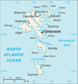
Welcome to the Google Maps of Faroe Islands (FO) and the comprehensive location list for this country. World Route Planner, together with its detailed Faroe Islands page, turns Google Maps Sightseeing into a meaningful experience! Our extensive destination gazetteer, coupled with Driving Directions to Faroe Islands, allows you to explore Faroe Islands through detailed satellite imagery and street views—fast, free, and easier than ever before.
Browse through the list of administrative regions in Faroe Islands, navigate through these regions to find a place of interest, and book your hotel with the Best Price Guarantee! Your journey through Faroe Islands via Google Satellite Map Sightseeing and Street View starts here.
Faroe Islands Google Maps
To activate Street View on any city of Faroe Islands, drag above the Zoom feature the yellow little man in the map.
Facts about Faroe Islands
| Administrative divisions: | none (part of the Kingdom of Denmark; self-governing overseas administrative division of Denmark); there are no first-order administrative divisions as defined by the US Government , but there are 34 municipalities |
| Area: | total: 1 ,399 sq km land: 1 ,399 sq km water: 0 sq km (some lakes and streams) |
| Background: | The population of the Faroe Islands is largely descended from Viking settlers who arrived in the 9th century. The islands have been connected politically to Denmark since the 14th century. A high degree of self government was attained in 1948. |
| Flag description: | white with a red cross outlined in blue extending to the edges of the flag; the vertical part of the cross is shifted toward the hoist side in the style of the Dannebrog (Danish flag) |
| Capital: | name: Torshavn geographic coordinates: 62 01 N , 6 46 W time difference: UTC 0 (5 hours ahead of Washington , DC during Standard Time) daylight saving time: +1hr , begins last Sunday in March; ends last Sunday in October |
| Climate: | mild winters , cool summers; usually overcast; foggy , windy |
| Currency code: | Danish krone (DKK) |
| Ethnic groups: | Scandinavian |
| Geographic coordinates: | 62 00 N , 7 00 W |
| Geography note: | archipelago of 17 inhabited islands and one uninhabited island , and a few uninhabited islets; strategically located along important sea lanes in northeastern Atlantic; precipitous terrain limits habitation to small coastal lowlands |
| Government type: | NA |
| Imports partners: | Denmark 52.3% , Norway 21.8% , Sweden 5.1% , UK 4.6% (2007) |
| Internet country code: | .fo |
| Land boundaries: | 1 ,117 km |
| Neighbouring countries: | 0 km |
| Languages: | Faroese (derived from Old Norse) , Danish |
| Location: | Northern Europe , island group between the Norwegian Sea and the North Atlantic Ocean , about half way between Iceland and Norway |
| Map references: | Europe |
| National holiday: | Olaifest (Olavasoka) , 29 July |
| Nationality: | noun: Faroese (singular and plural) adjective: Faroese |
| Natural hazards: | NA |
| Population: | 48 ,668 (July 2008 est.) |
| Religions: | Evangelical Lutheran 83.8% , other and unspecified 16.2% (2006 administrative data) |
| Terrain: | rugged , rocky , some low peaks; cliffs along most of coast |
| Unemployment rate: | 2.1% (2006) |
Capital of Faroe Islands
Tórshavn (click to view Tórshavn map)
Places in Faroe Islands
Browse the most comprehensive and up-to-date online directory of administrative regions and Street Views in Faroe Islands. Our listings are organized alphabetically, starting from level 1 regions and progressing through to level 2 and eventually level 3 regions, ensuring you can easily navigate and find specific areas of interest.
Akraberg city Google map
Akrar city Google map
Ánir city Google map
Argir city Google map
Árnafjørður city Google map
Biskupsstøð city Google map
Blankskáli city Google map
Bøur city Google map
Dalur city Google map
Depil city Google map
Djúpidalur city Google map
Eiði city Google map
Elduvík city Google map
Fámjin city Google map
Fodlendi city Google map
Fossá city Google map
Froðba city Google map
Fuglafjørður city Google map
Funningsfjørður city Google map
Funningur city Google map
Gásadalur city Google map
Gerðar city Google map
Gjánoyri city Google map
Gjógv city Google map
Gjógvin city Google map
Glyvrar city Google map
Grógv city Google map
Gøta city Google map
Gøtueiði city Google map
Gøtugjógv city Google map
Haldarsvík city Google map
Hamar city Google map
Hamrabyrgi city Google map
Haraldssund city Google map
Hattarvík city Google map
Hellur city Google map
Hestur city Google map
Heyggjur city Google map
Hólar city Google map
Hósvík city Google map
Hov city Google map
Hoyvík city Google map
Húsar city Google map
Húsavík city Google map
Hvalba city Google map
Hvalvík city Google map
Hvannasund city Google map
Hvítanes city Google map
Í Botni city Google map
Í Fámara city Google map
Í Húsi city Google map
Í Hørg city Google map
Innan Glyvur city Google map
Jansagerði city Google map
Kaldbak city Google map
Kirkja city Google map
Kirkjubøur city Google map
Kjalnes city Google map
Klaksvík city Google map
Kolbanargjógv city Google map
Kollafjørður city Google map
Koltur city Google map
Kráir city Google map
Krosslið city Google map
Kunoy city Google map
Kvívík city Google map
Lambareiði city Google map
Lambi city Google map
Langasandur city Google map
Leirvík city Google map
Leiti city Google map
Leynar city Google map
Líðin city Google map
Ljósá city Google map
Lopra city Google map
Mikladalur city Google map
Miðgerði city Google map
Miðvágur city Google map
Morskranes city Google map
Múli city Google map
Mykines city Google map
Myrkjanoyri city Google map
Nes city Google map
Nesið city Google map
Nólsoy city Google map
Norðdepil city Google map
Norðoyri city Google map
Norðradalur city Google map
Norðragøta city Google map
Norðskáli city Google map
Norðtoftir city Google map
Oman fyri Kirkju city Google map
Oyndarfjørður city Google map
Oyrarbakki city Google map
Oyrareingir city Google map
Oyrargjógv city Google map
Oyri city Google map
Porkeri city Google map
Punthavn city Google map
Rituvík city Google map
Runavík city Google map
Ryggur city Google map
Saksun city Google map
Saltangará city Google map
Saltnes city Google map
Sandagerði city Google map
Sandavágur city Google map
Sandur city Google map
Sandvík city Google map
Selatrað city Google map
Sevlendi city Google map
Signabøur city Google map
Sjóvartoftir city Google map
Skálafjørður city Google map
Skálar city Google map
Skálatoftir city Google map
Skálavík city Google map
Skáli city Google map
Skarvanes city Google map
Skarð city Google map
Skipanes city Google map
Skopun city Google map
Skúli city Google map
Skúvoy city Google map
Skælingur city Google map
Slættanes city Google map
Strendur city Google map
Streymnes city Google map
Strond city Google map
Stykkið city Google map
Sumba city Google map
Sund city Google map
Svínáir city Google map
Svínoy city Google map
Syðradalur city Google map
Syðrugøta city Google map
Søldarfjørður city Google map
Søltuvík city Google map
Sørvágur city Google map
Teigar city Google map
Tjørnuvík city Google map
Todnes city Google map
Toftanes city Google map
Toftir city Google map
Torkilsheyggjur city Google map
Tórshavn city Google map
Traðir city Google map
Trongisvágur city Google map
Trøllanes city Google map
Tvøroyri city Google map
Uppsalir city Google map
Uti á Fløtum city Google map
Vágsheygur city Google map
Vágur city Google map
Válur city Google map
Vatnsoyrar city Google map
Velbastaður city Google map
Vestmanna city Google map
Vikar city Google map
Víkarbyrgi city Google map
Við Garð city Google map
Við Kirkjar city Google map
Við Neyst city Google map
Við Sjógv city Google map
Viðareiði city Google map
Ytri Skáli city Google map
Æðuvík city Google map
Øravík city Google map
Random cities in Faroe Islands
Tórshavn, the capital city of Faroe Islands.Trøllanes
Hellur
Húsavík
Norðradalur
Tvøroyri
Haldarsvík
Søltuvík
Morskranes
Slættanes
Saltangará
Við Garð
Á Steig
Leirvík
Lambi
Biskupsstøð
Stykkið
Haraldssund
Kollafjørður
Sørvágur
Link to Faroe Islands Google Maps page
The map of Faroe Islands has already attracted 4425 views. If you wish to embed our comprehensive Faroe Islands map on your site, we offer an easy solution. This map includes free access to Google Maps, gazetteer search, detailed country and city maps, Street View, and essential facts, all ready to enhance your website. To use it, simply copy and paste the provided HTML code into your webpage's source code. We appreciate every link back to our Maps and Driving Directions. Thank you for your support!
| Text link to: Faroe Islands map and facts page |
This Faroe Islands map is intended solely for informational purposes. No representations or warranties are made concerning its accuracy or reliability. Users assume all risks associated with the use of Google Maps and Google Driving Directions. World Route Planner is not liable for any losses or delays that may occur from using this free Faroe Islands map.