 Gibraltar Google Maps and Facts
Welcome to the Google Maps of Gibraltar (GI) and the comprehensive location list for this country. World Route Planner, together with its detailed Gibraltar page, turns Google Maps Sightseeing into a meaningful experience! Our extensive destination gazetteer, coupled with Driving Directions to Gibraltar, allows you to explore Gibraltar through detailed satellite imagery and street views—fast, free, and easier than ever before.
Browse through the list of administrative regions in Gibraltar, navigate through these regions to find a place of interest, and book your hotel with the Best Price Guarantee! Your journey through Gibraltar via Google Satellite Map Sightseeing and Street View starts here.
Gibraltar Google Maps
To activate Street View on any city of Gibraltar, drag above the Zoom feature the yellow little man in the map.
Facts about Gibraltar
| Administrative divisions: | none (overseas territory of the UK) |
| Area: | total: 6.5 sq km land: 6.5 sq km water: 0 sq km |
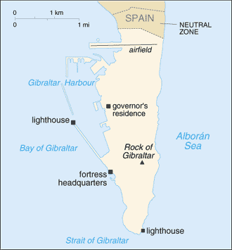
| Background: | Strategically important , Gibraltar was reluctantly ceded to Great Britain by Spain in the 1713 Treaty of Utrecht; the British garrison was formally declared a colony in 1830. In a referendum held in 1967 , Gibraltarians voted overwhelmingly to remain a British dependency. The subsequent granting of autonomy in 1969 by the UK led to Spain closing the border and severing all communication links. A series of talks were held by the UK and Spain between 1997 and 2002 on establishing temporary joint sovereignty over Gibraltar. In response to these talks , the Gibraltar Government called a referendum in late 2002 in which the majority of citizens voted overwhelmingly against any sharing of sovereignty with Spain. Since the referendum , tripartite talks on other issues have been held with Spain , the UK , and Gibraltar , and in September 2006 a three-way agreement was signed. Spain agreed to remove restrictions on air movements , to speed up customs procedures , to implement international telephone dialing , and to allow mobile roaming agreements. Britain agreed to pay increased pensions to Spaniards who had been employed in Gibraltar before the border closed. Spain will be allowed to open a cultural institute from which the Spanish flag will fly. A new noncolonial constitution came into effect in 2007 , but the UK retains responsibility for defense , foreign relations , internal security , and financial stability. |
| Flag description: | two horizontal bands of white (top , double width) and red with a three-towered red castle in the center of the white band; hanging from the castle gate is a gold key centered in the red band |
| Capital: | name: Gibraltar geographic coordinates: 36 08 N , 5 21 W time difference: UTC+1 (6 hours ahead of Washington , DC during Standard Time) daylight saving time: +1hr , begins last Sunday in March; ends last Sunday in October |
| Climate: | Mediterranean with mild winters and warm summers |
| Currency code: | Gibraltar pound (GIP) |
| Ethnic groups: | Spanish , Italian , English , Maltese , Portuguese , German , North Africans |
| Geographic coordinates: | 36 08 N , 5 21 W |
| Geography note: | strategic location on Strait of Gibraltar that links the North Atlantic Ocean and Mediterranean Sea |
| Government type: | NA |
| Imports partners: | Spain 23.4% , Russia 12.3% , Italy 12% , UK 9% , France 8.9% , Netherlands 6.8% , US 4.7% (2006) |
| Internet country code: | .gi |
| Land boundaries: | 12 km |
| Neighbouring countries: | total: 1.2 km border countries: Spain 1.2 km |
| Languages: | English (used in schools and for official purposes) , Spanish , Italian , Portuguese |
| Location: | Southwestern Europe , bordering the Strait of Gibraltar , which links the Mediterranean Sea and the North Atlantic Ocean , on the southern coast of Spain |
| Map references: | Europe |
| National holiday: | National Day , 10 September (1967); note - day of the national referendum to decide whether to remain with the UK or go with Spain |
| Nationality: | noun: Gibraltarian(s) adjective: Gibraltar |
| Natural hazards: | NA |
| Population: | 28 ,002 (July 2008 est.) |
| Religions: | Roman Catholic 78.1% , Church of England 7% , other Christian 3.2% , Muslim 4% , Jewish 2.1% , Hindu 1.8% , other or unspecified 0.9% , none 2.9% (2001 census) |
| Terrain: | a narrow coastal lowland borders the Rock of Gibraltar |
| Unemployment rate: | 3% (2005 est.) |
Capital of Gibraltar
Gibraltar (click to view Gibraltar map)
Places in Gibraltar
Browse the most comprehensive and up-to-date online directory of administrative regions and Street Views in Gibraltar. Our listings are organized alphabetically, starting from level 1 regions and progressing through to level 2 and eventually level 3 regions, ensuring you can easily navigate and find specific areas of interest.
Random cities in Gibraltar
Gibraltar, the capital city of Gibraltar.Link to Gibraltar Google Maps page
The map of Gibraltar has already attracted 5095 views. If you wish to embed our comprehensive Gibraltar map on your site, we offer an easy solution. This map includes free access to Google Maps, gazetteer search, detailed country and city maps, Street View, and essential facts, all ready to enhance your website. To use it, simply copy and paste the provided HTML code into your webpage's source code. We appreciate every link back to our Maps and Driving Directions. Thank you for your support!
| Text link to: Gibraltar map and facts page |
This Gibraltar map is intended solely for informational purposes. No representations or warranties are made concerning its accuracy or reliability. Users assume all risks associated with the use of Google Maps and Google Driving Directions. World Route Planner is not liable for any losses or delays that may occur from using this free Gibraltar map.