 Republic of Lithuania Google Maps and Facts
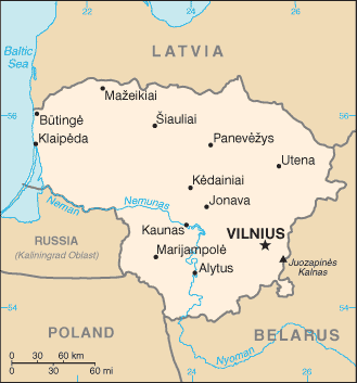
Welcome to the Google Maps of Lithuania (LT) and the comprehensive location list for this country. World Route Planner, together with its detailed Lithuania page, turns Google Maps Sightseeing into a meaningful experience! Our extensive destination gazetteer, coupled with Driving Directions to Lithuania, allows you to explore Lithuania through detailed satellite imagery and street views—fast, free, and easier than ever before.
Browse through the list of administrative regions in Lithuania, navigate through these regions to find a place of interest, and book your hotel with the Best Price Guarantee! Your journey through Lithuania via Google Satellite Map Sightseeing and Street View starts here.
Lithuania Google Maps
To activate Street View on any city of Lithuania, drag above the Zoom feature the yellow little man in the map.
Facts about Lithuania
| Administrative divisions: | 10 counties (apskritys , singular - apskritis); Alytaus , Kauno , Klaipedos , Marijampoles , Panevezio , Siauliu , Taurages , Telsiu , Utenos , Vilniaus |
| Area: | total: 65 ,300 sq km land: NA sq km water: NA sq km |
| Background: | Lithuanian lands were united under MINDAUGAS in 1236; over the next century , through alliances and conquest , Lithuania extended its territory to include most of present-day Belarus and Ukraine. By the end of the 14th century Lithuania was the largest state in Europe. An alliance with Poland in 1386 led the two countries into a union through the person of a common ruler. In 1569 , Lithuania and Poland formally united into a single dual state , the Polish-Lithuanian Commonwealth. This entity survived until 1795 , when its remnants were partitioned by surrounding countries. Lithuania regained its independence following World War I but was annexed by the USSR in 1940 - an action never recognized by the US and many other countries. On 11 March 1990 , Lithuania became the first of the Soviet republics to declare its independence , but Moscow did not recognize this proclamation until September of 1991 (following the abortive coup in Moscow). The last Russian troops withdrew in 1993. Lithuania subsequently restructured its economy for integration into Western European institutions; it joined both NATO and the EU in the spring of 2004. |
| Flag description: | three equal horizontal bands of yellow (top) , green , and red |
| Capital: | name: Vilnius geographic coordinates: 54 41 N , 25 19 E time difference: UTC+2 (7 hours ahead of Washington , DC during Standard Time) daylight saving time: +1hr , begins last Sunday in March; ends last Sunday in October |
| Climate: | transitional , between maritime and continental; wet , moderate winters and summers |
| Currency code: | litas (LTL) |
| Ethnic groups: | Lithuanian 83.4% , Polish 6.7% , Russian 6.3% , other or unspecified 3.6% (2001 census) |
| Geographic coordinates: | 56 00 N , 24 00 E |
| Geography note: | fertile central plains are separated by hilly uplands that are ancient glacial deposits |
| Government type: | parliamentary democracy |
| Imports partners: | Russia 18.1% , Germany 14.9% , Poland 10.6% , Latvia 5.5% , Netherlands 4.2% (2007) |
| Internet country code: | .lt |
| Land boundaries: | 90 km |
| Neighbouring countries: | total: 1 ,574 km border countries: Belarus 680 km , Latvia 576 km , Poland 91 km , Russia (Kaliningrad) 227 km |
| Languages: | Lithuanian (official) 82% , Russian 8% , Polish 5.6% , other and unspecified 4.4% (2001 census) |
| Location: | Eastern Europe , bordering the Baltic Sea , between Latvia and Russia |
| Map references: | Europe |
| National holiday: | Independence Day , 16 February (1918); note - 16 February 1918 was the date Lithuania declared its independence from Soviet Russia and established its statehood; 11 March 1990 was the date it declared its independence from the Soviet Union |
| Nationality: | noun: Lithuanian(s) adjective: Lithuanian |
| Natural hazards: | NA |
| Population: | 3 ,565 ,205 (July 2008 est.) |
| Religions: | Roman Catholic 79% , Russian Orthodox 4.1% , Protestant (including Lutheran and Evangelical Christian Baptist) 1.9% , other or unspecified 5.5% , none 9.5% (2001 census) |
| Terrain: | lowland , many scattered small lakes , fertile soil |
| Unemployment rate: | 3.5% note: based on survey data , official registered unemployment of 5.7% (2007 est.) |
Capital of Republic of Lithuania
Vilnius (click to view Vilnius map)
Places in Lithuania
Browse the most comprehensive and up-to-date online directory of administrative regions and Street Views in Lithuania. Our listings are organized alphabetically, starting from level 1 regions and progressing through to level 2 and eventually level 3 regions, ensuring you can easily navigate and find specific areas of interest.
Ančiškis city Google map
Andrietiškiai city Google map
Antkalnė city Google map
Antkalniškiai city Google map
Antlaukė city Google map
Anužiai city Google map
Apvaršuva city Google map
Arnionys II city Google map
Asiūklė city Google map
Ašvėnai city Google map
Aukšbikavis city Google map
Aukštašlynis city Google map
Aukštuoliai city Google map
Bačkonys city Google map
Bakainiai city Google map
Bakaloriškiai city Google map
Balandžiai city Google map
Baldegiai city Google map
Balsariškės city Google map
Balsiai city Google map
Baltrušiškiai city Google map
Baraviškiai city Google map
Bardžiai city Google map
Bargailiai city Google map
Bariai city Google map
Barkūnai city Google map
Bebirvai city Google map
Bebrikiai city Google map
Beižionys city Google map
Beržynai city Google map
Bikavenai city Google map
Bilaišiai city Google map
Bliūdžiai city Google map
Bokšeiniai city Google map
Braziūkai city Google map
Bučioniai city Google map
Būda city Google map
Būdvietis city Google map
Bulavėnai city Google map
Buožiai city Google map
Burgaičiai city Google map
Būriškės city Google map
Butrimiškiai city Google map
Būtvilai city Google map
Čepaičiai city Google map
Cinorpievis city Google map
Čiobiškis city Google map
Dabšionys city Google map
Dalgai city Google map
Danylos city Google map
Dauginava city Google map
Daujotėliai city Google map
Daukšinė city Google map
Devynduoniai city Google map
Didieji Mostaičiai city Google map
Didžiasalis city Google map
Domantai city Google map
Dubiniai city Google map
Dusmenėliai city Google map
Dvariškiai city Google map
Dyburiai city Google map
Eigirdonys city Google map
Eitučiai city Google map
Gaideliškiai city Google map
Gailekiemis city Google map
Gailioniai city Google map
Galsdonai city Google map
Gančiūnai city Google map
Gaulėnai city Google map
Gedanonys city Google map
Gelučiai city Google map
Gelžyčiai city Google map
Genėtiniai city Google map
Giegiai city Google map
Gilučiai city Google map
Gineitiškės city Google map
Ginteniai city Google map
Gipenai city Google map
Girelė city Google map
Girinčiai city Google map
Gomaliai city Google map
Greičiai city Google map
Greikonys city Google map
Greistė city Google map
Grigaliūnai city Google map
Gubiejis city Google map
Gudeliai city Google map
Guikaliai city Google map
Gumbinė city Google map
Gvaldai city Google map
Ibutoniai city Google map
Ilguva city Google map
Išlandžiai city Google map
Jackagalys city Google map
Janapolis city Google map
Jaunonys city Google map
Jiestrakis city Google map
Joginiškiai I city Google map
Joginiškiai II city Google map
Jokavai city Google map
Jokūbaičiai city Google map
Joniškis city Google map
Josūdai city Google map
Juodaičiai city Google map
Juodainiai city Google map
Juodeliai city Google map
Jurbarkas city Google map
Jurgionys city Google map
Jusėnai city Google map
Juškai city Google map
Kaimelis city Google map
Kalbutiškės city Google map
Kalnėnai city Google map
Kapėnai city Google map
Kapstatai city Google map
Karševiškiai city Google map
Kartupis city Google map
Kaugonys city Google map
Kaukinė city Google map
Kaunatava city Google map
Kauno Apskritis (948 google map locations)
Kavoliai city Google map
Kazokai city Google map
Kebiškiai city Google map
Keidžiai city Google map
Kelmanonys city Google map
Keršiškiai city Google map
Kesai city Google map
Kiauneliškis city Google map
Kiaužeriai city Google map
Kiduliai city Google map
Kijučiai city Google map
Kilova I city Google map
Kilova II city Google map
Kirkliai city Google map
Klaipėdos Apskritis (564 google map locations)
Klaišiškiai city Google map
Klangiai city Google map
Kliūkiai city Google map
Knitiškiai city Google map
Kopūstėliai city Google map
Krantai city Google map
Kraujaleidžiai city Google map
Kregždyne city Google map
Kriemala city Google map
Kritižis city Google map
Kriūkai city Google map
Kryžkalnis city Google map
Kuišiai city Google map
Kūjėnai city Google map
Kulkiškės city Google map
Kundrėnai city Google map
Kupriškiai city Google map
Kuronys city Google map
Kuršiai city Google map
Laižuva city Google map
Lapkasės city Google map
Lažai city Google map
Legotė city Google map
Leinartiškė city Google map
Lekėčiai city Google map
Lembas city Google map
Levikainiai Aukštieji city Google map
Liaubarai city Google map
Liepkalnis city Google map
Lipkiškė city Google map
Liutonys city Google map
Lūgnaliai city Google map
Luoba city Google map
Lyduvėnai city Google map
Lygiai city Google map
Macaičiai city Google map
Mamiai city Google map
Mančiušėnai city Google map
Maniškiai city Google map
Marijampolės Apskritis (390 google map locations)
Maudžiorai city Google map
Mauliai city Google map
Mazgiai city Google map
Mažučiai city Google map
Mediniškiai city Google map
Meldžiūnai city Google map
Meškiai city Google map
Mickiškiai city Google map
Miksodis city Google map
Mišiūnai city Google map
Mitkiškės city Google map
Moluvėnai city Google map
Mūro Strėvininkai city Google map
Naujapieviai city Google map
Naujasodė city Google map
Nausodė city Google map
Očiki city Google map
Ožaičiai city Google map
Pabalvė city Google map
Paberžė city Google map
Padruskalnys city Google map
Padvariai city Google map
Paežerėliai city Google map
Pagausantys I city Google map
Pagausantys II city Google map
Pageležiai city Google map
Pagirgždūtė city Google map
Pagiriai city Google map
Paišlynys city Google map
Pajautiškiai city Google map
Pajomantis city Google map
Pakalniškiai city Google map
Pakamoniai city Google map
Pakarklys II city Google map
Pakritižis city Google map
Palapišiai city Google map
Palazdžiai city Google map
Palėkiai city Google map
Palioniškiai city Google map
Palolytis city Google map
Palūkštis city Google map
Panemuniškiai city Google map
Panevėžio Apskritis (632 google map locations)
Papilvis city Google map
Papiškiai city Google map
Paramotis city Google map
Pašeikis city Google map
Pašilė city Google map
Pašilėliai city Google map
Pastulgiai city Google map
Patumšiai city Google map
Paupstaliai city Google map
Paupys city Google map
Pauslajys city Google map
Pavandenė city Google map
Paviščiovys city Google map
Pečiuliai city Google map
Pėdiškė city Google map
Pelišyšos II city Google map
Pėriškiai city Google map
Peštvėnai city Google map
Pėteraičiai city Google map
Petkiškiai city Google map
Petraičiai city Google map
Pikeliai city Google map
Piktagalis city Google map
Pilis city Google map
Plaukiai city Google map
Pleikiškiai city Google map
Plekiai city Google map
Pleteriškė city Google map
Plokščiai city Google map
Plunkėnai city Google map
Plutiškės city Google map
Praščiūnai city Google map
Purviškiai city Google map
Pusnė city Google map
Putramentiškė city Google map
Putrišiai city Google map
Putriškės city Google map
Radiškis city Google map
Raguvėlė city Google map
Ramonai city Google map
Ramoniškiai city Google map
Raudonė city Google map
Raudonėnai city Google map
Reiskiai city Google map
Rekščiai city Google map
Rėkučiai city Google map
Resčiai city Google map
Rėzgaliai city Google map
Ridikiai city Google map
Riečiai city Google map
Ringovė city Google map
Rinkšeliai city Google map
Roglaičiai I city Google map
Rundžiai city Google map
Ruška city Google map
Rūtakiemis city Google map
Šakėnai city Google map
Šakiniai city Google map
Šapis city Google map
Šaukliai city Google map
Sėleniai city Google map
Seredžius city Google map
Šerlaukis city Google map
Šermukšniai city Google map
Šeštokai city Google map
Severėnai city Google map
Šiaulių Apskritis (978 google map locations)
Šilininkai city Google map
Sinkonys city Google map
Sitkūnai city Google map
Skamaičiai city Google map
Skiručiai city Google map
Skiržemė city Google map
Skliausčiai city Google map
Skrandėnai city Google map
Skriaudžiai city Google map
Skudeniai city Google map
Šlapgirė city Google map
Sliekiškės city Google map
Sližiai city Google map
Smalininkai city Google map
Šmėltynė city Google map
Šniūrai city Google map
Sodalė city Google map
Sodeliškiai city Google map
Spilgiai city Google map
Špūliai city Google map
Stempliai city Google map
Stirbiškė city Google map
Stokaičiai city Google map
Strėvininkai city Google map
Stropeliai city Google map
Strošiunai city Google map
Strumbagalvė city Google map
Stulgiai city Google map
Stumbragirėliai city Google map
Stumbragiriai city Google map
Sudargas city Google map
Sudvariškės city Google map
Sugintai city Google map
Sūkuriai city Google map
Šunikiai city Google map
Surviliškis city Google map
Švenčgalis city Google map
Švendūna city Google map
Taubučiai city Google map
Taučionys city Google map
Tauragės Apskritis (598 google map locations)
Telšių Apskritis (367 google map locations)
Tilvikai city Google map
Timsriai city Google map
Tirkšlioniai city Google map
Trakai city Google map
Trakininkai city Google map
Trakmiai city Google map
Tūrai city Google map
Unkuriai city Google map
Upyna city Google map
Utėnai city Google map
Utenos Apskritis (304 google map locations)
Užkamunė city Google map
Užpelkiai city Google map
Užpurviai city Google map
Užupė city Google map
Vadaktai city Google map
Vailabai city Google map
Vailainiai city Google map
Vainočiai city Google map
Vaitiekūnai city Google map
Valašinai city Google map
Valatkaičiai city Google map
Valatkaičiukai city Google map
Vėjeliškiai city Google map
Vejos city Google map
Vėlaičiai city Google map
Veliouna city Google map
Veniai city Google map
Verkuliškė city Google map
Vienragiai city Google map
Vilkiškiai city Google map
Vilnaliai city Google map
Vilniaus Apskritis (629 google map locations)
Vosbutai city Google map
Vosiliškis city Google map
Vyšniūnai city Google map
Žagariai city Google map
Žaliūkė city Google map
Žalpiai city Google map
Žeberiai city Google map
Želkūnai city Google map
Žemaitaičiai city Google map
Žemalėnai city Google map
Žemoji Panemunė city Google map
Žibartoniai city Google map
Žiliai city Google map
Žiopeliai city Google map
Žirnainiai city Google map
Žiūronys city Google map
Živavodė city Google map
Žvingiai city Google map
Žvirgždžiai city Google map
Žvirgždžiūnai city Google map
Žvirzdė city Google map
Žvynėnai city Google map
Žylakiai city Google map
Random cities in Lithuania
Vilnius, the capital city of Lithuania.Lukšiai
Payslykis
Mikailaičiai
Dagilioniai
Rėpšaičiai
Kurmaičiai
Traklaukas
Prienai
Ašakieniai
Nemajūnai
Peliūnai
Sargeliai
Kuigaliai
Antšunijai
Prūdupė
Jėrubiškiai
Alksnėnai
Užušiliai
Užvėdarė
Link to Lithuania Google Maps page
The map of Lithuania has already attracted 7300 views. If you wish to embed our comprehensive Lithuania map on your site, we offer an easy solution. This map includes free access to Google Maps, gazetteer search, detailed country and city maps, Street View, and essential facts, all ready to enhance your website. To use it, simply copy and paste the provided HTML code into your webpage's source code. We appreciate every link back to our Maps and Driving Directions. Thank you for your support!
| Text link to: Lithuania map and facts page |
This Lithuania map is intended solely for informational purposes. No representations or warranties are made concerning its accuracy or reliability. Users assume all risks associated with the use of Google Maps and Google Driving Directions. World Route Planner is not liable for any losses or delays that may occur from using this free Lithuania map.