 Grand Duchy of Luxembourg Google Maps and Facts
Welcome to the Google Maps of Luxembourg (LU) and the comprehensive location list for this country. World Route Planner, together with its detailed Luxembourg page, turns Google Maps Sightseeing into a meaningful experience! Our extensive destination gazetteer, coupled with Driving Directions to Luxembourg, allows you to explore Luxembourg through detailed satellite imagery and street views—fast, free, and easier than ever before.
Browse through the list of administrative regions in Luxembourg, navigate through these regions to find a place of interest, and book your hotel with the Best Price Guarantee! Your journey through Luxembourg via Google Satellite Map Sightseeing and Street View starts here.
Luxembourg Google Maps
To activate Street View on any city of Luxembourg, drag above the Zoom feature the yellow little man in the map.
Facts about Luxembourg
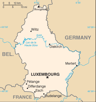
| Administrative divisions: | 3 districts; Diekirch , Grevenmacher , Luxembourg |
| Area: | total: 2 ,586 sq km land: 2 ,586 sq km water: 0 sq km |
| Background: | Founded in 963 , Luxembourg became a grand duchy in 1815 and an independent state under the Netherlands. It lost more than half of its territory to Belgium in 1839 , but gained a larger measure of autonomy. Full independence was attained in 1867. Overrun by Germany in both World Wars , it ended its neutrality in 1948 when it entered into the Benelux Customs Union and when it joined NATO the following year. In 1957 , Luxembourg became one of the six founding countries of the European Economic Community (later the European Union) , and in 1999 it joined the euro currency area. |
| Flag description: | three equal horizontal bands of red (top) , white , and light blue; similar to the flag of the Netherlands , which uses a darker blue and is shorter; design was based on the flag of France |
| Capital: | name: Luxembourg geographic coordinates: 49 36 N , 6 07 E time difference: UTC+1 (6 hours ahead of Washington , DC during Standard Time) daylight saving time: +1hr , begins last Sunday in March; ends last Sunday in October |
| Climate: | modified continental with mild winters , cool summers |
| Currency code: | euro (EUR) |
| Ethnic groups: | Luxembourger 63.1% , Portuguese 13.3% , French 4.5% , Italian 4.3% , German 2.3% , other EU 7.3% , other 5.2% (2000 census) |
| Geographic coordinates: | 49 45 N , 6 10 E |
| Geography note: | landlocked; the only Grand Duchy in the world |
| Government type: | constitutional monarchy |
| Imports partners: | Belgium 27.4% , Germany 23.8% , China 17.1% , France 9.2% , Netherlands 5% (2007) |
| Internet country code: | .lu |
| Land boundaries: | 0 km (landlocked) |
| Neighbouring countries: | total: 359 km border countries: Belgium 148 km , France 73 km , Germany 138 km |
| Languages: | Luxembourgish (national language) , German (administrative language) , French (administrative language) |
| Location: | Western Europe , between France and Germany |
| Map references: | Europe |
| National holiday: | National Day (Birthday of Grand Duchess Charlotte) 23 June; note - the actual date of birth was 23 January 1896 , but the festivities were shifted by five months to allow observance during a more favorable time of year |
| Nationality: | noun: Luxembourger(s) adjective: Luxembourg |
| Natural hazards: | NA |
| Population: | 486 ,006 (July 2008 est.) |
| Religions: | Roman Catholic 87% , other (includes Protestant , Jewish , and Muslim) 13% (2000) |
| Terrain: | mostly gently rolling uplands with broad , shallow valleys; uplands to slightly mountainous in the north; steep slope down to Moselle flood plain in the southeast |
| Unemployment rate: | 4.4% (2007 est.) |
Capital of Grand Duchy of Luxembourg
Luxembourg (click to view Luxembourg map)
Places in Luxembourg
Browse the most comprehensive and up-to-date online directory of administrative regions and Street Views in Luxembourg. Our listings are organized alphabetically, starting from level 1 regions and progressing through to level 2 and eventually level 3 regions, ensuring you can easily navigate and find specific areas of interest.
Random cities in Luxembourg
Luxembourg, the capital city of Luxembourg.Graulinster
Foetz
Grevelscheuer
Bous
Weicherdange
Calmus
Dellen
Eppeldorf
Grevenmacher
Kayl
Lorentzweiler
Limpertsberg
Hobscheid
Kockelscheuer
Italien
Essingen
Eltz
Heiderscheid
Jenkenhof
Link to Luxembourg Google Maps page
The map of Luxembourg has already attracted 5835 views. If you wish to embed our comprehensive Luxembourg map on your site, we offer an easy solution. This map includes free access to Google Maps, gazetteer search, detailed country and city maps, Street View, and essential facts, all ready to enhance your website. To use it, simply copy and paste the provided HTML code into your webpage's source code. We appreciate every link back to our Maps and Driving Directions. Thank you for your support!
| Text link to: Luxembourg map and facts page |
This Luxembourg map is intended solely for informational purposes. No representations or warranties are made concerning its accuracy or reliability. Users assume all risks associated with the use of Google Maps and Google Driving Directions. World Route Planner is not liable for any losses or delays that may occur from using this free Luxembourg map.