 Territory of Guam Google Maps and Facts
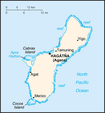
Welcome to the Google Maps of Guam (GU) and the comprehensive location list for this country. World Route Planner, together with its detailed Guam page, turns Google Maps Sightseeing into a meaningful experience! Our extensive destination gazetteer, coupled with Driving Directions to Guam, allows you to explore Guam through detailed satellite imagery and street views—fast, free, and easier than ever before.
Browse through the list of administrative regions in Guam, navigate through these regions to find a place of interest, and book your hotel with the Best Price Guarantee! Your journey through Guam via Google Satellite Map Sightseeing and Street View starts here.
Guam Google Maps
To activate Street View on any city of Guam, drag above the Zoom feature the yellow little man in the map.
Facts about Guam
| Administrative divisions: | none (territory of the US) |
| Area: | total: 541.3 sq km land: 541.3 sq km water: 0 sq km |
| Background: | Guam was ceded to the US by Spain in 1898. Captured by the Japanese in 1941 , it was retaken by the US three years later. The military installation on the island is one of the most strategically important US bases in the Pacific. |
| Flag description: | territorial flag is dark blue with a narrow red border on all four sides; centered is a red-bordered , pointed , vertical ellipse containing a beach scene , outrigger canoe with sail , and a palm tree with the word GUAM superimposed in bold red letters; US flag is the national flag |
| Capital: | name: Hagatna (Agana) geographic coordinates: 13 28 N , 144 44 E time difference: UTC+10 (15 hours ahead of Washington , DC during Standard Time) |
| Climate: | tropical marine; generally warm and humid , moderated by northeast trade winds; dry season (January to June) , rainy season (July to December); little seasonal temperature variation |
| Currency code: | US dollar (USD) |
| Ethnic groups: | Chamorro 37.1% , Filipino 26.3% , other Pacific islander 11.3% , white 6.9% , other Asian 6.3% , other ethnic origin or race 2.3% , mixed 9.8% (2000 census) |
| Geographic coordinates: | 13 28 N , 144 47 E |
| Geography note: | largest and southernmost island in the Mariana Islands archipelago; strategic location in western North Pacific Ocean |
| Government type: | NA |
| Imports partners: | Singapore 50% , South Korea 21.4% , Japan 14% , Hong Kong 4.6% (2006) |
| Internet country code: | .gu |
| Land boundaries: | 125.5 km |
| Neighbouring countries: | 0 km |
| Languages: | English 38.3% , Chamorro 22.2% , Philippine languages 22.2% , other Pacific island languages 6.8% , Asian languages 7% , other languages 3.5% (2000 census) |
| Location: | Oceania , island in the North Pacific Ocean , about three-quarters of the way from Hawaii to the Philippines |
| Map references: | Oceania |
| National holiday: | Discovery Day , first Monday in March (1521) |
| Nationality: | noun: Guamanian(s) (US citizens) adjective: Guamanian |
| Natural hazards: | frequent squalls during rainy season; relatively rare , but potentially very destructive typhoons (June - December) |
| Population: | 175 ,877 (July 2008 est.) |
| Religions: | Roman Catholic 85% , other 15% (1999 est.) |
| Terrain: | volcanic origin , surrounded by coral reefs; relatively flat coralline limestone plateau (source of most fresh water) , with steep coastal cliffs and narrow coastal plains in north , low hills in center , mountains in south |
| Unemployment rate: | 11.4% (2002 est.) |
Capital of Territory of Guam
[PLACE_CAPITAL] (click to view [PLACE_CAPITAL] map)
Places in Guam
Browse the most comprehensive and up-to-date online directory of administrative regions and Street Views in Guam. Our listings are organized alphabetically, starting from level 1 regions and progressing through to level 2 and eventually level 3 regions, ensuring you can easily navigate and find specific areas of interest.
Adelup city Google map
Afami city Google map
Agafo Gumas city Google map
Agat city Google map
Anigua city Google map
Apra Heights city Google map
Apra Junction city Google map
Apurguan city Google map
Asagas city Google map
Asan city Google map
Asatdas city Google map
Asbeco city Google map
Asfaja city Google map
Asmisen city Google map
Asmuyao city Google map
Aspengo city Google map
Astumbo city Google map
Ayuja city Google map
Bacuna city Google map
Barrigada city Google map
Barrigada Heights city Google map
Baza Gardens city Google map
Bile city Google map
Bingot city Google map
Biyae city Google map
Calacag city Google map
Camp Dealy city Google map
Camp Roxas city Google map
Canada city Google map
Carlos Heights city Google map
Catan Maga city Google map
Cerain city Google map
Chagamin Lago city Google map
Chalan Mamajanao city Google map
Chalan Pago city Google map
Coontz Junction city Google map
Corten Torres city Google map
Dededo city Google map
East Hagåtña city Google map
Flora Pago Gardens city Google map
Gayinero city Google map
Hagåtña city Google map
Hagåtña Heights city Google map
Harmon Garden city Google map
Harmon Village city Google map
Inarajan city Google map
Ipapao city Google map
Jaotan city Google map
Jonestown city Google map
Julog city Google map
Lalo city Google map
Latte Heights Estates city Google map
Latte Plantation city Google map
Leary Junction city Google map
Leyan city Google map
Liguan Terrace city Google map
Lingae city Google map
Lockwood Terrace city Google map
Lupog city Google map
Machaute city Google map
Maina city Google map
Maite city Google map
Marianas Terrace city Google map
Matugan city Google map
Mayaya city Google map
Merizo city Google map
Mongmong city Google map
North Tipalao city Google map
Oceanview city Google map
Oka city Google map
Ordot city Google map
Pado city Google map
Paseo De Oro city Google map
Peca city Google map
Perez Acres city Google map
Piga city Google map
Pigo city Google map
Pigua city Google map
Piti city Google map
Ponderosa Gardens city Google map
Potts Junction city Google map
Royal Garden city Google map
Salinas city Google map
Salisbury Junction city Google map
San Antonio city Google map
San Ramon city Google map
San Vicente city Google map
Santa Rita city Google map
Santa Rosa city Google map
Schroeder Junction city Google map
Sella city Google map
Sinajana city Google map
Socio city Google map
South Acres city Google map
South Tipalao city Google map
Sumay city Google map
Sumay Housing Area city Google map
Tacpi city Google map
Talofofo city Google map
Talona city Google map
Tamuning city Google map
Tepungan city Google map
Tijera city Google map
Toa city Google map
Toto city Google map
Tres Reyes city Google map
Tumalaglago city Google map
Tumon city Google map
Tumon Chama city Google map
Tumon Heights city Google map
Tutujan city Google map
Umatac city Google map
Ungaguan city Google map
Upper Kaiser city Google map
Utan city Google map
Wettengel Junction city Google map
Witek Junction city Google map
Yabai city Google map
Yigo city Google map
Yigo Estates city Google map
Yona city Google map
Ypan city Google map
Ypaopao Estates city Google map
Random cities in Guam
[PLACE_CAPITAL], the capital city of Guam.Tepungan
Maite
Sumay Housing Area
Bingot
Oceanview
Ordot
Asfaja
Asmisen
Astumbo
Tumon Heights
Talofofo
Bacuna
Asmuyao
Latte Plantation
Hagåtña Heights
Agafo Gumas
Schroeder Junction
Toto
Inarajan
Link to Guam Google Maps page
The map of Guam has already attracted 4828 views. If you wish to embed our comprehensive Guam map on your site, we offer an easy solution. This map includes free access to Google Maps, gazetteer search, detailed country and city maps, Street View, and essential facts, all ready to enhance your website. To use it, simply copy and paste the provided HTML code into your webpage's source code. We appreciate every link back to our Maps and Driving Directions. Thank you for your support!
| Text link to: Guam map and facts page |
This Guam map is intended solely for informational purposes. No representations or warranties are made concerning its accuracy or reliability. Users assume all risks associated with the use of Google Maps and Google Driving Directions. World Route Planner is not liable for any losses or delays that may occur from using this free Guam map.