 Territory of Norfolk Island Google Maps and Facts
Welcome to the Google Maps of Norfolk Island (NF) and the comprehensive location list for this country. World Route Planner, together with its detailed Norfolk Island page, turns Google Maps Sightseeing into a meaningful experience! Our extensive destination gazetteer, coupled with Driving Directions to Norfolk Island, allows you to explore Norfolk Island through detailed satellite imagery and street views—fast, free, and easier than ever before.
Browse through the list of administrative regions in Norfolk Island, navigate through these regions to find a place of interest, and book your hotel with the Best Price Guarantee! Your journey through Norfolk Island via Google Satellite Map Sightseeing and Street View starts here.
Norfolk Island Google Maps
To activate Street View on any city of Norfolk Island, drag above the Zoom feature the yellow little man in the map.
Facts about Norfolk Island
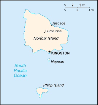
| Administrative divisions: | none (territory of Australia) |
| Area: | total: 34.6 sq km land: 34.6 sq km water: 0 sq km |
| Background: | Two British attempts at establishing the island as a penal colony (1788-1814 and 1825-55) were ultimately abandoned. In 1856 , the island was resettled by Pitcairn Islanders , descendants of the Bounty mutineers and their Tahitian companions. |
| Flag description: | three vertical bands of green (hoist side) , white , and green with a large green Norfolk Island pine tree centered in the slightly wider white band |
| Capital: | name: Kingston geographic coordinates: 29 03 S , 167 58 E time difference: UTC+11.5 (16.5 hours ahead of Washington , DC during Standard Time) |
| Climate: | subtropical; mild , little seasonal temperature variation |
| Currency code: | Australian dollar (AUD) |
| Ethnic groups: | descendants of the Bounty mutineers , Australian , New Zealander , Polynesian |
| Geographic coordinates: | 29 02 S , 167 57 E |
| Geography note: | most of the 32 km coastline consists of almost inaccessible cliffs , but the land slopes down to the sea in one small southern area on Sydney Bay , where the capital of Kingston is situated |
| Government type: | NA |
| Imports partners: | Australia , other Pacific island countries , NZ , Asia , Europe (2006) |
| Internet country code: | .nf |
| Land boundaries: | 32 km |
| Neighbouring countries: | 0 km |
| Languages: | English (official) , Norfolk - a mixture of 18th century English and ancient Tahitian |
| Location: | Oceania , island in the South Pacific Ocean , east of Australia |
| Map references: | Oceania |
| National holiday: | Bounty Day (commemorates the arrival of Pitcairn Islanders) , 8 June (1856) |
| Nationality: | noun: Norfolk Islander(s) adjective: Norfolk Islander(s) |
| Natural hazards: | typhoons (especially May to July) |
| Population: | 2 ,128 (July 2008 est.) |
| Religions: | Anglican 31.8% , Roman Catholic 11.5% , Uniting Church in Australia 10.6% , Seventh-Day Adventist 3.2% , other Christian 5.6% , none 19.9% , unspecified 16.6% (2006 census) |
| Terrain: | volcanic formation with mostly rolling plains |
| Unemployment rate: |
Capital of Territory of Norfolk Island
[PLACE_CAPITAL] (click to view [PLACE_CAPITAL] map)
Places in Norfolk Island
Browse the most comprehensive and up-to-date online directory of administrative regions and Street Views in Norfolk Island. Our listings are organized alphabetically, starting from level 1 regions and progressing through to level 2 and eventually level 3 regions, ensuring you can easily navigate and find specific areas of interest.
Random cities in Norfolk Island
[PLACE_CAPITAL], the capital city of Norfolk Island.Link to Norfolk Island Google Maps page
The map of Norfolk Island has already attracted 2998 views. If you wish to embed our comprehensive Norfolk Island map on your site, we offer an easy solution. This map includes free access to Google Maps, gazetteer search, detailed country and city maps, Street View, and essential facts, all ready to enhance your website. To use it, simply copy and paste the provided HTML code into your webpage's source code. We appreciate every link back to our Maps and Driving Directions. Thank you for your support!
| Text link to: Norfolk Island map and facts page |
This Norfolk Island map is intended solely for informational purposes. No representations or warranties are made concerning its accuracy or reliability. Users assume all risks associated with the use of Google Maps and Google Driving Directions. World Route Planner is not liable for any losses or delays that may occur from using this free Norfolk Island map.