 Commonwealth of the Northern Mariana Islands Google Maps and Facts
Map of Northern Mariana Islands ⇣ | Google Maps of Northern Mariana Islands ⇣ | All Places in Northern Mariana Islands ⇣
Welcome to the Google Maps of Northern Mariana Islands (MP) and the comprehensive location list for this country. World Route Planner, together with its detailed Northern Mariana Islands page, turns Google Maps Sightseeing into a meaningful experience! Our extensive destination gazetteer, coupled with Driving Directions to Northern Mariana Islands, allows you to explore Northern Mariana Islands through detailed satellite imagery and street views—fast, free, and easier than ever before.
Browse through the list of administrative regions in Northern Mariana Islands, navigate through these regions to find a place of interest, and book your hotel with the Best Price Guarantee! Your journey through Northern Mariana Islands via Google Satellite Map Sightseeing and Street View starts here.
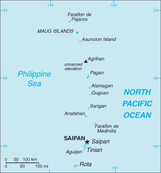
Northern Mariana Islands Google Maps
To activate Street View on any city of Northern Mariana Islands, drag above the Zoom feature the yellow little man in the map.
Facts about Northern Mariana Islands
| Administrative divisions: | none (commonwealth in political union with the US); there are no first-order administrative divisions as defined by the US Government , but there are four municipalities at the second order: Northern Islands , Rota , Saipan , Tinian |
| Area: | total: 477 sq km land: 477 sq km water: 0 sq km note: includes 14 islands including Saipan , Rota , and Tinian |
| Background: | Under US administration as part of the UN Trust Territory of the Pacific , the people of the Northern Mariana Islands decided in the 1970s not to seek independence but instead to forge closer links with the US. Negotiations for territorial status began in 1972. A covenant to establish a commonwealth in political union with the US was approved in 1975 , and came into force on 24 March 1976. A new government and constitution went into effect in 1978. |
| Flag description: | blue , with a white , five-pointed star superimposed on the gray silhouette of a latte stone (a traditional foundation stone used in building) in the center , surrounded by a wreath |
| Capital: | name: Saipan geographic coordinates: 15 12 N , 145 45 E time difference: UTC+10 (15 hours ahead of Washington , DC during Standard Time) |
| Climate: | tropical marine; moderated by northeast trade winds , little seasonal temperature variation; dry season December to June , rainy season July to October |
| Currency code: | US dollar (USD) |
| Ethnic groups: | Asian 56.3% , Pacific islander 36.3% , Caucasian 1.8% , other 0.8% , mixed 4.8% (2000 census) |
| Geographic coordinates: | 15 12 N , 145 45 E |
| Geography note: | strategic location in the North Pacific Ocean |
| Government type: | commonwealth; self-governing with locally elected governor , lieutenant governor , and legislature |
| Imports partners: | US , Japan (2006) |
| Internet country code: | .mp |
| Land boundaries: | 1 ,482 km |
| Neighbouring countries: | 0 km |
| Languages: | Philippine languages 24.4% , Chinese 23.4% , Chamorro 22.4% , English 10.8% , other Pacific island languages 9.5% , other 9.6% (2000 census) |
| Location: | Oceania , islands in the North Pacific Ocean , about three-quarters of the way from Hawaii to the Philippines |
| Map references: | Oceania |
| National holiday: | Commonwealth Day , 8 January (1978) |
| Nationality: | noun: NA (US citizens) adjective: NA |
| Natural hazards: | active volcanoes on Pagan and Agrihan; typhoons (especially August to November) |
| Population: | 86 ,616 (July 2008 est.) |
| Religions: | Christian (Roman Catholic majority , although traditional beliefs and taboos may still be found) |
| Terrain: | southern islands are limestone with level terraces and fringing coral reefs; northern islands are volcanic |
| Unemployment rate: | 3.9% (2001) |
Capital of Commonwealth of the Northern Mariana Islands
[PLACE_CAPITAL] (click to view [PLACE_CAPITAL] map)
Places in Northern Mariana Islands
Browse the most comprehensive and up-to-date online directory of administrative regions and Street Views in Northern Mariana Islands. Our listings are organized alphabetically, starting from level 1 regions and progressing through to level 2 and eventually level 3 regions, ensuring you can easily navigate and find specific areas of interest.
Capital Hill city Google map
Capitol Hill city Google map
Chalan Kanoa city Google map
Chalan Kiya city Google map
Garapan city Google map
Gualo Rai city Google map
Kagman city Google map
Koblerville city Google map
Laolao, Chalan city Google map
Marasu city Google map
Navy Hill city Google map
Oleai city Google map
Pi'ao, Chalan city Google map
Pupulu, Chalan city Google map
San Antonio city Google map
San Jose city Google map
San Roque city Google map
San Vicente city Google map
San Vincente city Google map
Shomushon city Google map
Sinapalo city Google map
Songsong city Google map
Susupe city Google map
Susupi city Google map
Tanapag city Google map
Random cities in Northern Mariana Islands
[PLACE_CAPITAL], the capital city of Northern Mariana Islands.Koblerville
Oleai
Marasu
San Roque
Susupi
Afetna
San Jose
Songsong
Tanapag
San Antonio
Laolao, Chalan
Pupulu, Chalan
Susupe
Garapan
Pi'ao, Chalan
Capitol Hill
Sinapalo
Navy Hill
Kagman
Link to Northern Mariana Islands Google Maps page
The map of Northern Mariana Islands has already attracted 3671 views. If you wish to embed our comprehensive Northern Mariana Islands map on your site, we offer an easy solution. This map includes free access to Google Maps, gazetteer search, detailed country and city maps, Street View, and essential facts, all ready to enhance your website. To use it, simply copy and paste the provided HTML code into your webpage's source code. We appreciate every link back to our Maps and Driving Directions. Thank you for your support!
| Text link to: Northern Mariana Islands map and facts page |
This Northern Mariana Islands map is intended solely for informational purposes. No representations or warranties are made concerning its accuracy or reliability. Users assume all risks associated with the use of Google Maps and Google Driving Directions. World Route Planner is not liable for any losses or delays that may occur from using this free Northern Mariana Islands map.