 Tokelau Google Maps and Facts
Welcome to the Google Maps of Tokelau (TK) and the comprehensive location list for this country. World Route Planner, together with its detailed Tokelau page, turns Google Maps Sightseeing into a meaningful experience! Our extensive destination gazetteer, coupled with Driving Directions to Tokelau, allows you to explore Tokelau through detailed satellite imagery and street views—fast, free, and easier than ever before.
Browse through the list of administrative regions in Tokelau, navigate through these regions to find a place of interest, and book your hotel with the Best Price Guarantee! Your journey through Tokelau via Google Satellite Map Sightseeing and Street View starts here.
Tokelau Google Maps
To activate Street View on any city of Tokelau, drag above the Zoom feature the yellow little man in the map.
Facts about Tokelau
| Administrative divisions: | none (territory of New Zealand) |
| Area: | total: 10 sq km land: 10 sq km water: 0 sq km |
| Background: | Originally settled by Polynesian emigrants from surrounding island groups , the Tokelau Islands were made a British protectorate in 1889. They were transferred to New Zealand administration in 1925. Referenda held in 2006 and 2007 to change the status of the islands from that of a New Zealand territory to one of free association with New Zealand did not meet the needed threshold for approval. |
| Flag description: | the flag of New Zealand is used |
| Capital: | none; each atoll has its own administrative center time difference: UTC-11 (6 hours behind Washington , DC during Standard Time) |
| Climate: | tropical; moderated by trade winds (April to November) |
| Currency code: | |
| Ethnic groups: | Polynesian |
| Geographic coordinates: | 9 00 S , 172 00 W |
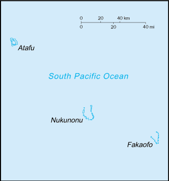
| Geography note: | consists of three atolls (Atafu , Fakaofo , Nukunonu) , each with a lagoon surrounded by a number of reef-bound islets of varying length and rising to over 3 m above sea level |
| Government type: | NA |
| Imports partners: | New Zealand (2006) |
| Internet country code: | .tk |
| Land boundaries: | 101 km |
| Neighbouring countries: | 0 km |
| Languages: | Tokelauan (a Polynesian language) , English |
| Location: | Oceania , group of three atolls in the South Pacific Ocean , about one-half of the way from Hawaii to New Zealand |
| Map references: | Oceania |
| National holiday: | Waitangi Day (Treaty of Waitangi established British sovereignty over New Zealand) , 6 February (1840) |
| Nationality: | noun: Tokelauan(s) adjective: Tokelauan |
| Natural hazards: | lies in Pacific typhoon belt |
| Population: | 1 ,433 (July 2008 est.) |
| Religions: | Congregational Christian Church 70% , Roman Catholic 28% , other 2% note: on Atafu , all Congregational Christian Church of Samoa; on Nukunonu , all Roman Catholic; on Fakaofo , both denominations , with the Congregational Christian Church predominant |
| Terrain: | low-lying coral atolls enclosing large lagoons |
| Unemployment rate: | NA% |
Capital of Tokelau
[PLACE_CAPITAL] (click to view [PLACE_CAPITAL] map)
Places in Tokelau
Browse the most comprehensive and up-to-date online directory of administrative regions and Street Views in Tokelau. Our listings are organized alphabetically, starting from level 1 regions and progressing through to level 2 and eventually level 3 regions, ensuring you can easily navigate and find specific areas of interest.