 Co-operative Republic of Guyana Google Maps and facts
Welcome to Google Maps of Guyana (GY) and locations list of this country. World Route Planner and its detailed Guyana page is the place where Google Maps Sightseeing make sense! With comprehensive destination gazetteer, Driving Directions to Guyana, World Route Planner enables you to explore Guyana through detailed Satellite Imagery and Street View - fast, free and easy as never before. Browse the list of administrative regions below of Guyana, follow the navigation through administrative regions to find a place you are interested in and Book your hotel with Best Price Guarantee! Your Guyana Google Satellite Map Sightseeing and Street View start here.
To activate Street View on any city of Guyana, drag above the Zoom feature the yellow little man in the map.
Facts about Guyana
| Administrative divisions: | 10 regions; Barima-Waini , Cuyuni-Mazaruni , Demerara-Mahaica , East Berbice-Corentyne , Essequibo Islands-West Demerara , Mahaica-Berbice , Pomeroon-Supenaam , Potaro-Siparuni , Upper Demerara-Berbice , Upper Takutu-Upper Essequibo |
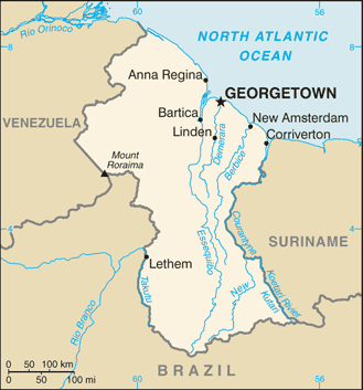
| Area: | total: 214 ,970 sq km land: 196 ,850 sq km water: 18 ,120 sq km |
| Background: | Originally a Dutch colony in the 17th century , by 1815 Guyana had become a British possession. The abolition of slavery led to black settlement of urban areas and the importation of indentured servants from India to work the sugar plantations. This ethnocultural divide has persisted and has led to turbulent politics. Guyana achieved independence from the UK in 1966 , and since then it has been ruled mostly by socialist-oriented governments. In 1992 , Cheddi JAGAN was elected president in what is considered the country's first free and fair election since independence. After his death five years later , his wife , Janet JAGAN , became president but resigned in 1999 due to poor health. Her successor , Bharrat JAGDEO , was reelected in 2001 and again in 2006. |
| Flag description: | green , with a red isosceles triangle (based on the hoist side) superimposed on a long , yellow arrowhead; there is a narrow , black border between the red and yellow , and a narrow , white border between the yellow and the green |
| Capital: | name: Georgetown geographic coordinates: 6 48 N , 58 10 W time difference: UTC-4 (1 hour ahead of Washington , DC during Standard Time) |
| Climate: | tropical; hot , humid , moderated by northeast trade winds; two rainy seasons (May to August , November to January) |
| Currency code: | Guyanese dollar (GYD) |
| Ethnic groups: | East Indian 43.5% , black (African) 30.2% , mixed 16.7% , Amerindian 9.1% , other 0.5% (2002 census) |
| Geographic coordinates: | 5 00 N , 59 00 W |
| Geography note: | the third-smallest country in South America after Suriname and Uruguay; substantial portions of its western and eastern territories are claimed by Venezuela and Suriname respectively |
| Government type: | republic |
| Imports partners: | Trinidad and Tobago 25.6% , US 20% , Cuba 7.1% , China 7% , UK 5.3% (2007) |
| Internet country code: | .gy |
| Land boundaries: | 459 km |
| Neighbouring countries: | total: 2 ,949 km border countries: Brazil 1 ,606 km , Suriname 600 km , Venezuela 743 km |
| Languages: | English , Amerindian dialects , Creole , Caribbean Hindustani (a dialect of Hindi) , Urdu |
| Location: | Northern South America , bordering the North Atlantic Ocean , between Suriname and Venezuela |
| Map references: | South America |
| National holiday: | Republic Day , 23 February (1970) |
| Nationality: | noun: Guyanese (singular and plural) adjective: Guyanese |
| Natural hazards: | flash floods are a constant threat during rainy seasons |
| Population: | 770 ,794 note: estimates for this country explicitly take into account the effects of excess mortality due to AIDS; this can result in lower life expectancy , higher infant mortality , higher death rates , lower population growth rates , and changes in the distribution of population by age and sex than would otherwise be expected (July 2008 est.) |
| Religions: | Hindu 28.4% , Pentecostal 16.9% , Roman Catholic 8.1% , Anglican 6.9% , Seventh Day Adventist 5% , Methodist 1.7% , Jehovah Witness 1.1% , other Christian 17.7% , Muslim 7.2% , other 4.3% , none 4.3% (2002 census) |
| Terrain: | mostly rolling highlands; low coastal plain; savanna in south |
| Unemployment rate: | 9.1% (understated) (2000) |
Capital of Co-operative Republic of Guyana
Georgetown (click to view Georgetown map)
Places in Guyana
Browse the most comprehensive and up-to-date online directory of administrative regions and Street views in Guyana. Regions are sorted in alphabetical order from level 1 to level 2 and eventually up to level 3 regions.
Cuyuni-Mazaruni Region (47 google map locations)
Demerara-Mahaica Region (51 google map locations)
East Berbice-Corentyne Region (34 google map locations)
Essequibo Islands-West Demerara Region (31 google map locations)
Pomeroon-Supenaam Region (25 google map locations)
Potaro-Siparuni Region (20 google map locations)
Upper Demerara-Berbice Region (20 google map locations)
Upper Takutu-Upper Essequibo Region (61 google map locations)
Random cities in Guyana
Georgetown, the capital city of Guyana.Blygezight
Glasgow Village
Kingston
Lumidpau
Meritizero
Mahdia
Aurora
Beribissiballi
Pubu
Ekereku
Kamwatta Hill
Low Wood
Kariaku
Java
Ipotaikuru
Manari
Marlborough
Pomona
Igupa Village
This Guyana map is for informational use only. No representation is made or warranty given as to its content. User assumes all risk of using Google Maps and Google Driving Directions. World Route Planner assumes no responsibility for any loss or delay resulting from such use of free Guyana map.
Link to Guyana Google Maps page
This map of Guyana has been viewed 7713 times until now. In case you would like, there is a very easy way how to link to our Guyana map - including free Google Maps, gazetteer search, country, city maps, Street View and facts -, ready to use on your website. Please, simply copy & paste the provided HTML code into your page source code: Thank you for all links to our Maps and Driving Directions!
| Text link to: Guyana map |