 Republic of Suriname Google Maps and Facts
Welcome to the Google Maps of Suriname (SR) and the comprehensive location list for this country. World Route Planner, together with its detailed Suriname page, turns Google Maps Sightseeing into a meaningful experience! Our extensive destination gazetteer, coupled with Driving Directions to Suriname, allows you to explore Suriname through detailed satellite imagery and street views—fast, free, and easier than ever before.
Browse through the list of administrative regions in Suriname, navigate through these regions to find a place of interest, and book your hotel with the Best Price Guarantee! Your journey through Suriname via Google Satellite Map Sightseeing and Street View starts here.
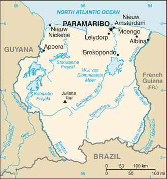
Suriname Google Maps
To activate Street View on any city of Suriname, drag above the Zoom feature the yellow little man in the map.
Facts about Suriname
| Administrative divisions: | 10 districts (distrikten , singular - distrikt); Brokopondo , Commewijne , Coronie , Marowijne , Nickerie , Para , Paramaribo , Saramacca , Sipaliwini , Wanica |
| Area: | total: 163 ,270 sq km land: 161 ,470 sq km water: 1 ,800 sq km Svalbard |
| Background: | First explored by the Spaniards in the 16th century and then settled by the English in the mid-17th century , Suriname became a Dutch colony in 1667. With the abolition of slavery in 1863 , workers were brought in from India and Java. Independence from the Netherlands was granted in 1975. Five years later the civilian government was replaced by a military regime that soon declared a socialist republic. It continued to exert control through a succession of nominally civilian administrations until 1987 , when international pressure finally forced a democratic election. In 1990 , the military overthrew the civilian leadership , but a democratically elected government - a four-party New Front coalition - returned to power in 1991 and has ruled since; the coalition expanded to eight parties in 2005. Svalbard |
| Flag description: | five horizontal bands of green (top , double width) , white , red (quadruple width) , white , and green (double width); there is a large , yellow , five-pointed star centered in the red band Svalbard |
| Capital: | name: Paramaribo geographic coordinates: 5 50 N , 55 10 W time difference: UTC-3 (2 hours ahead of Washington , DC during Standard Time) Svalbard |
| Climate: | tropical; moderated by trade winds Svalbard |
| Currency code: | |
| Ethnic groups: | Hindustani (also known locally as "East Indians"; their ancestors emigrated from northern India in the latter part of the 19th century) 37% , Creole (mixed white and black) 31% , Javanese 15% , "Maroons" (their African ancestors were brought to the country in the 17th and 18th centuries as slaves and escaped to the interior) 10% , Amerindian 2% , Chinese 2% , white 1% , other 2% Svalbard |
| Geographic coordinates: | 4 00 N , 56 00 W Svalbard |
| Geography note: | smallest independent country on South American continent; mostly tropical rain forest; great diversity of flora and fauna that , for the most part , is increasingly threatened by new development; relatively small population , mostly along the coast Svalbard |
| Government type: | constitutional democracy Svalbard |
| Imports partners: | US 27.2% , Netherlands 17.4% , Trinidad and Tobago 14.4% , China 6% , Japan 5.1% (2007) |
| Internet country code: | .sr Svalbard |
| Land boundaries: | 386 km Svalbard |
| Neighbouring countries: | total: 1 ,703 km border countries: Brazil 593 km , French Guiana 510 km , Guyana 600 km Svalbard |
| Languages: | Dutch (official) , English (widely spoken) , Sranang Tongo (Surinamese , sometimes called Taki-Taki , is native language of Creoles and much of the younger population and is lingua franca among others) , Caribbean Hindustani (a dialect of Hindi) , Javanese Svalbard |
| Location: | Northern South America , bordering the North Atlantic Ocean , between French Guiana and Guyana Svalbard |
| Map references: | South America Svalbard |
| National holiday: | Independence Day , 25 November (1975) |
| Nationality: | noun: Surinamer(s) adjective: Surinamese |
| Natural hazards: | NA Svalbard |
| Population: | 475 ,996 (July 2008 est.) Svalbard |
| Religions: | Hindu 27.4% , Protestant 25.2% (predominantly Moravian) , Roman Catholic 22.8% , Muslim 19.6% , indigenous beliefs 5% |
| Terrain: | mostly rolling hills; narrow coastal plain with swamps Svalbard |
| Unemployment rate: | 9.5% (2004) |
Capital of Republic of Suriname
Paramaribo (click to view Paramaribo map)
Places in Suriname
Browse the most comprehensive and up-to-date online directory of administrative regions and Street Views in Suriname. Our listings are organized alphabetically, starting from level 1 regions and progressing through to level 2 and eventually level 3 regions, ensuring you can easily navigate and find specific areas of interest.
Commewijne District (52 google map locations)
Coronie District (11 google map locations)
Marowijne District (50 google map locations)
Nickerie District (17 google map locations)
Paramaribo District (7 google map locations)
Saramacca District (33 google map locations)
Sipaliwini District (161 google map locations)
Wanica District (5 google map locations)
Random cities in Suriname
Paramaribo, the capital city of Suriname.Antonigron
Saje
Auca
Kapasie Kree
Spieringshoek
Crappahoek
Dampoentoeng
Reynsdorp
Calcutta
Alliance
Djoemoe
Santigron
Kopi Ondroo
Asidonkondre
Oemakondre
Tomemoené
Acote
Nieuw Nickerie
Fijetti
Link to Suriname Google Maps page
The map of Suriname has already attracted 5047 views. If you wish to embed our comprehensive Suriname map on your site, we offer an easy solution. This map includes free access to Google Maps, gazetteer search, detailed country and city maps, Street View, and essential facts, all ready to enhance your website. To use it, simply copy and paste the provided HTML code into your webpage's source code. We appreciate every link back to our Maps and Driving Directions. Thank you for your support!
| Text link to: Suriname map and facts page |
This Suriname map is intended solely for informational purposes. No representations or warranties are made concerning its accuracy or reliability. Users assume all risks associated with the use of Google Maps and Google Driving Directions. World Route Planner is not liable for any losses or delays that may occur from using this free Suriname map.