 Union of the Comoros Google Maps and facts
Welcome to Google Maps of Comoros (KM) and locations list of this country. World Route Planner and its detailed Comoros page is the place where Google Maps Sightseeing make sense! With comprehensive destination gazetteer, Driving Directions to Comoros, World Route Planner enables you to explore Comoros through detailed Satellite Imagery and Street View - fast, free and easy as never before. Browse the list of administrative regions below of Comoros, follow the navigation through administrative regions to find a place you are interested in and Book your hotel with Best Price Guarantee! Your Comoros Google Satellite Map Sightseeing and Street View start here.
To activate Street View on any city of Comoros, drag above the Zoom feature the yellow little man in the map.
Facts about Comoros
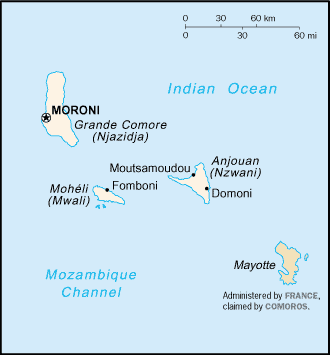
| Administrative divisions: | 3 islands and 4 municipalities*; Grande Comore , Anjouan , Domoni* , Fomboni* , Moheli , Moroni* , Mutsamudu* |
| Area: | total: 2 ,170 sq km land: 2 ,170 sq km water: 0 sq km |
| Background: | Comoros has endured more than 20 coups or attempted coups since gaining independence from France in 1975. In 1997 , the islands of Anjouan and Moheli declared independence from Comoros. In 1999 , military chief Col. AZALI seized power in a bloodless coup , and helped negotiate the 2000 Fomboni Accords power-sharing agreement in which the federal presidency rotates among the three islands , and each island maintains its own local government. AZALI won the 2002 Presidential election , and each island in the archipelago elected its own president. AZALI stepped down in 2006 and President SAMBI took office. Since 2006 , Anjouan's President Mohamed BACAR has refused to work effectively with the Union presidency. In 2007 , BACAR effected Anjouan's de-facto secession from the Union , refusing to step down in favor of fresh Anjouanais elections when Comoros' other islands held legitimate elections in July. The African Union (AU) initially attempted to resolve the political crisis by applying sanctions and a naval blockade on Anjouan , but in March 2008 , AU and Comoran soldiers seized the island. The move was generally welcomed by the island's inhabitants. |
| Flag description: | four equal horizontal bands of yellow (top) , white , red , and blue with a green isosceles triangle based on the hoist; centered within the triangle is a white crescent with the convex side facing the hoist and four white , five-pointed stars placed vertically in a line between the points of the crescent; the horizontal bands and the four stars represent the four main islands of the archipelago - Mwali , Njazidja , Nzwani , and Mahore (Mayotte - territorial collectivity of France , but claimed by Comoros) note: the crescent , stars , and color green are traditional symbols of Islam |
| Capital: | name: Moroni geographic coordinates: 11 42 S , 43 14 E time difference: UTC+3 (8 hours ahead of Washington , DC during Standard Time) |
| Climate: | tropical marine; rainy season (November to May) |
| Currency code: | Comoran franc (KMF) |
| Ethnic groups: | Antalote , Cafre , Makoa , Oimatsaha , Sakalava |
| Geographic coordinates: | 12 10 S , 44 15 E |
| Geography note: | important location at northern end of Mozambique Channel |
| Government type: | republic |
| Imports partners: | France 17.8% , UAE 10.6% , South Africa 8.3% , Pakistan 7% , Kenya 5.6% , China 5.3% , India 4.9% (2007) |
| Internet country code: | .km |
| Land boundaries: | 340 km |
| Neighbouring countries: | 0 km |
| Languages: | Arabic (official) , French (official) , Shikomoro (a blend of Swahili and Arabic) |
| Location: | Southern Africa , group of islands at the northern mouth of the Mozambique Channel , about two-thirds of the way between northern Madagascar and northern Mozambique |
| Map references: | Africa |
| National holiday: | Independence Day , 6 July (1975) |
| Nationality: | noun: Comoran(s) adjective: Comoran |
| Natural hazards: | cyclones possible during rainy season (December to April); Le Kartala on Grand Comore is an active volcano |
| Population: | 731 ,775 (July 2008 est.) |
| Religions: | Sunni Muslim 98% , Roman Catholic 2% |
| Terrain: | volcanic islands , interiors vary from steep mountains to low hills |
| Unemployment rate: | 20% (1996 est.) |
Capital of Union of the Comoros
Moroni (click to view Moroni map)
Places in Comoros
Browse the most comprehensive and up-to-date online directory of administrative regions and Street views in Comoros. Regions are sorted in alphabetical order from level 1 to level 2 and eventually up to level 3 regions.
Random cities in Comoros
Moroni, the capital city of Comoros.Guamarumbo
Mdji Diakagnoa
Mkirijou
Antsahé
Damou
Hahaïa
Demeani
Mbambani
Helendjé
Sima Ambouani
Chamro
Mro Mouhouli
Daouéni
Djoumbe
Hada-Haïa
Mbachilé
Mitréni
Pomoni
Domoni Adjou
This Comoros map is for informational use only. No representation is made or warranty given as to its content. User assumes all risk of using Google Maps and Google Driving Directions. World Route Planner assumes no responsibility for any loss or delay resulting from such use of free Comoros map.
Link to Comoros Google Maps page
This map of Comoros has been viewed 2794 times until now. In case you would like, there is a very easy way how to link to our Comoros map - including free Google Maps, gazetteer search, country, city maps, Street View and facts -, ready to use on your website. Please, simply copy & paste the provided HTML code into your page source code: Thank you for all links to our Maps and Driving Directions!
| Text link to: Comoros map |