 Republic of The Gambia Google Maps and Facts
Welcome to the Google Maps of Gambia, The (GM) and the comprehensive location list for this country. World Route Planner, together with its detailed Gambia, The page, turns Google Maps Sightseeing into a meaningful experience! Our extensive destination gazetteer, coupled with Driving Directions to Gambia, The, allows you to explore Gambia, The through detailed satellite imagery and street views—fast, free, and easier than ever before.
Browse through the list of administrative regions in Gambia, The, navigate through these regions to find a place of interest, and book your hotel with the Best Price Guarantee! Your journey through Gambia, The via Google Satellite Map Sightseeing and Street View starts here.
Gambia, The Google Maps
To activate Street View on any city of Gambia, The, drag above the Zoom feature the yellow little man in the map.
Facts about Gambia, The
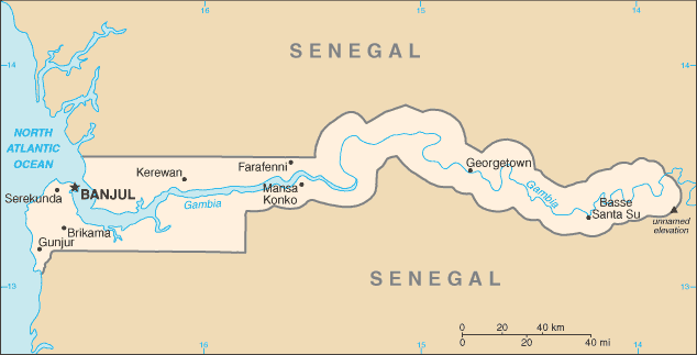
| Administrative divisions: | 5 divisions and 1 city*; Banjul* , Central River , Lower River , North Bank , Upper River , Western |
| Area: | total: 11 ,300 sq km land: 10 ,000 sq km water: 1 ,300 sq km Gaza Strip |
| Background: | The Gambia gained its independence from the UK in 1965. Geographically surrounded by Senegal , it formed a short-lived federation of Senegambia between 1982 and 1989. In 1991 the two nations signed a friendship and cooperation treaty , but tensions have flared up intermittently since then. Yahya A. J. J. JAMMEH led a military coup in 1994 that overthrew the president and banned political activity. A new constitution and presidential elections in 1996 , followed by parliamentary balloting in 1997 , completed a nominal return to civilian rule. JAMMEH has been elected president in all subsequent elections , including most recently in late 2006. Gaza Strip |
| Flag description: | three equal horizontal bands of red (top) , blue with white edges , and green |
| Capital: | name: Banjul geographic coordinates: 13 27 N , 16 34 W time difference: UTC 0 (5 hours ahead of Washington , DC during Standard Time) |
| Climate: | tropical; hot , rainy season (June to November); cooler , dry season (November to May) Gaza Strip |
| Currency code: | dalasi (GMD) Gaza Strip |
| Ethnic groups: | African 99% (Mandinka 42% , Fula 18% , Wolof 16% , Jola 10% , Serahuli 9% , other 4%) , non-African 1% (2003 census) Gaza Strip |
| Geographic coordinates: | 13 28 N , 16 34 W Gaza Strip |
| Geography note: | almost an enclave of Senegal; smallest country on the continent of Africa Gaza Strip |
| Government type: | republic |
| Imports partners: | China 24% , Senegal 11.7% , Cote d'Ivoire 8.4% , Brazil 6.8% , Netherlands 5.3% (2007) Gaza Strip |
| Internet country code: | .gm Gaza Strip |
| Land boundaries: | 80 km Gaza Strip |
| Neighbouring countries: | total: 740 km border countries: Senegal 740 km Gaza Strip |
| Languages: | English (official) , Mandinka , Wolof , Fula , other indigenous vernaculars Gaza Strip |
| Location: | Western Africa , bordering the North Atlantic Ocean and Senegal Gaza Strip |
| Map references: | Africa Gaza Strip |
| National holiday: | Independence Day , 18 February (1965) |
| Nationality: | noun: Gambian(s) adjective: Gambian Gaza Strip |
| Natural hazards: | drought (rainfall has dropped by 30% in the last 30 years) Gaza Strip |
| Population: | 1 ,735 ,464 (July 2008 est.) Gaza Strip |
| Religions: | Muslim 90% , Christian 8% , indigenous beliefs 2% Gaza Strip |
| Terrain: | flood plain of the Gambia River flanked by some low hills Gaza Strip |
| Unemployment rate: | NA% Gaza Strip |
Capital of Republic of The Gambia
Banjul (click to view Banjul map)
Places in Gambia, The
Browse the most comprehensive and up-to-date online directory of administrative regions and Street Views in Gambia, The. Our listings are organized alphabetically, starting from level 1 regions and progressing through to level 2 and eventually level 3 regions, ensuring you can easily navigate and find specific areas of interest.
Bamba Jallow city Google map
Banniba Jonki city Google map
Baro Kunda city Google map
Barra Kunda city Google map
Budayell city Google map
Central River Division (598 google map locations)
City of Banjul (1 google map locations)
Dankunku city Google map
Dankunku Fula city Google map
Demati Kunda city Google map
Demba Darboe city Google map
Demba Kunda city Google map
Diemballa Ker Cherno city Google map
Diemballa Ker Musa city Google map
Dinguiri city Google map
Dinkirai city Google map
Dongoro Nding city Google map
Fass Mbaien city Google map
Hamdalai city Google map
Hamdalie city Google map
Ja Koto city Google map
Jallow Koto city Google map
Jama Gen city Google map
Jamwell city Google map
Jataly city Google map
Joba city Google map
Kalikajara city Google map
Kamamudu city Google map
Kanape city Google map
Kansambou city Google map
Kau-ur city Google map
Ker Alpha Sana city Google map
Ker Jaho city Google map
Ker Katim city Google map
Ker Madi city Google map
Ker N'Gissay city Google map
Ker Tiern city Google map
Kiberi city Google map
Kunda city Google map
Kuryande city Google map
Kusaie city Google map
Lower River Division (143 google map locations)
Madina Njugari city Google map
Makajan city Google map
Makajan Kunda city Google map
Makama city Google map
Mamadi Sisi city Google map
Mbaien Sara Kumba Kah city Google map
Missera Amadou Badjan city Google map
Modu Jawo Kunda city Google map
Mure Kunda city Google map
Niawoorulung city Google map
Njallal city Google map
North Bank Division (288 google map locations)
Sare Sandi city Google map
Sarkuli Kunda city Google map
Si Kunda city Google map
Sondeh Densay city Google map
Tabanani city Google map
Tuba Mbakeh city Google map
Upper River Division (339 google map locations)
Wellingara Ello city Google map
Western Division (447 google map locations)
Random cities in Gambia, The
Banjul, the capital city of Gambia, The.Tia
Albadarr
Sare Babu
Bambako
Nemasamba
Sare Ali
Sutukung
Mbaien Burama
Torben
Bati Yungo
Sareh Mowndeh
Sare Ndala
Kesereh
Numyell
Bamba Kolong
Jabbi Kunda
N'Dungu Kebbe
Samba Sotor
Ker Samba
Link to Gambia, The Google Maps page
The map of Gambia, The has already attracted 5054 views. If you wish to embed our comprehensive Gambia, The map on your site, we offer an easy solution. This map includes free access to Google Maps, gazetteer search, detailed country and city maps, Street View, and essential facts, all ready to enhance your website. To use it, simply copy and paste the provided HTML code into your webpage's source code. We appreciate every link back to our Maps and Driving Directions. Thank you for your support!
| Text link to: Gambia, The map and facts page |
This Gambia, The map is intended solely for informational purposes. No representations or warranties are made concerning its accuracy or reliability. Users assume all risks associated with the use of Google Maps and Google Driving Directions. World Route Planner is not liable for any losses or delays that may occur from using this free Gambia, The map.