 Republic of Ghana Google Maps and facts
Welcome to Google Maps of Ghana (GH) and locations list of this country. World Route Planner and its detailed Ghana page is the place where Google Maps Sightseeing make sense! With comprehensive destination gazetteer, Driving Directions to Ghana, World Route Planner enables you to explore Ghana through detailed Satellite Imagery and Street View - fast, free and easy as never before. Browse the list of administrative regions below of Ghana, follow the navigation through administrative regions to find a place you are interested in and Book your hotel with Best Price Guarantee! Your Ghana Google Satellite Map Sightseeing and Street View start here.
To activate Street View on any city of Ghana, drag above the Zoom feature the yellow little man in the map.
Facts about Ghana
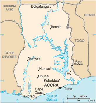
| Administrative divisions: | 10 regions; Ashanti , Brong-Ahafo , Central , Eastern , Greater Accra , Northern , Upper East , Upper West , Volta , Western |
| Area: | total: 239 ,460 sq km land: 230 ,940 sq km water: 8 ,520 sq km |
| Background: | Formed from the merger of the British colony of the Gold Coast and the Togoland trust territory , Ghana in 1957 became the first sub-Saharan country in colonial Africa to gain its independence. Ghana endured a long series of coups before Lt. Jerry RAWLINGS took power in 1981 and banned political parties. After approving a new constitution and restoring multiparty politics in 1992 , RAWLINGS won presidential elections in 1992 and 1996 , but was constitutionally prevented from running for a third term in 2000. John KUFUOR succeeded him and was reelected in 2004. Kufuor is constitutionally barred from running for a third term in upcoming Presidential elections , which are scheduled for December 2008. |
| Flag description: | three equal horizontal bands of red (top) , yellow , and green with a large black five-pointed star centered in the yellow band; uses the popular pan-African colors of Ethiopia; similar to the flag of Bolivia , which has a coat of arms centered in the yellow band |
| Capital: | name: Accra geographic coordinates: 5 33 N , 0 13 W time difference: UTC 0 (5 hours ahead of Washington , DC during Standard Time) |
| Climate: | tropical; warm and comparatively dry along southeast coast; hot and humid in southwest; hot and dry in north |
| Currency code: | Ghana cedi (GHC) |
| Ethnic groups: | Akan 45.3% , Mole-Dagbon 15.2% , Ewe 11.7% , Ga-Dangme 7.3% , Guan 4% , Gurma 3.6% , Grusi 2.6% , Mande-Busanga 1% , other tribes 1.4% , other 7.8% (2000 census) |
| Geographic coordinates: | 8 00 N , 2 00 W |
| Geography note: | Lake Volta is the world's largest artificial lake |
| Government type: | constitutional democracy |
| Imports partners: | Nigeria 15.3% , China 15.1% , UK 5.2% , US 5.1% (2007) |
| Internet country code: | .gh |
| Land boundaries: | 539 km |
| Neighbouring countries: | total: 2 ,094 km border countries: Burkina Faso 549 km , Cote d'Ivoire 668 km , Togo 877 km |
| Languages: | Asante 14.8% , Ewe 12.7% , Fante 9.9% , Boron (Brong) 4.6% , Dagomba 4.3% , Dangme 4.3% , Dagarte (Dagaba) 3.7% , Akyem 3.4% , Ga 3.4% , Akuapem 2.9% , other 36.1% (includes English (official)) (2000 census) |
| Location: | Western Africa , bordering the Gulf of Guinea , between Cote d'Ivoire and Togo |
| Map references: | Africa |
| National holiday: | Independence Day , 6 March (1957) |
| Nationality: | noun: Ghanaian(s) adjective: Ghanaian |
| Natural hazards: | dry , dusty , northeastern harmattan winds occur from January to March; droughts |
| Population: | 23 ,382 ,848 note: estimates for this country explicitly take into account the effects of excess mortality due to AIDS; this can result in lower life expectancy , higher infant mortality , higher death rates , lower population growth rates , and changes in the distribution of population by age and sex than would otherwise be expected (July 2008 est.) |
| Religions: | Christian 68.8% (Pentecostal/Charismatic 24.1% , Protestant 18.6% , Catholic 15.1% , other 11%) , Muslim 15.9% , traditional 8.5% , other 0.7% , none 6.1% (2000 census) |
| Terrain: | mostly low plains with dissected plateau in south-central area |
| Unemployment rate: | 11% (2000 est.) |
Capital of Republic of Ghana
Accra (click to view Accra map)
Places in Ghana
Browse the most comprehensive and up-to-date online directory of administrative regions and Street views in Ghana. Regions are sorted in alphabetical order from level 1 to level 2 and eventually up to level 3 regions.
Brong-Ahafo Region (465 google map locations)
Central Region (1111 google map locations)
Eastern Region (863 google map locations)
Greater Accra Region (476 google map locations)
Upper East Region (608 google map locations)
Upper West Region (367 google map locations)
Volta Region (1221 google map locations)
Western Region (1156 google map locations)
Random cities in Ghana
Accra, the capital city of Ghana.Mprenchi
Komfeku
Sucherema
Enuensuso
Kawsan
Nkwantanang
Wuehima
Zoa
Safam
Asesua
Konkone Abetima
Dareba
Kedjebi
Dawusaso
Seneso
Anyoum
Brunkum
Bejei
Chireayowa
This Ghana map is for informational use only. No representation is made or warranty given as to its content. User assumes all risk of using Google Maps and Google Driving Directions. World Route Planner assumes no responsibility for any loss or delay resulting from such use of free Ghana map.
Link to Ghana Google Maps page
This map of Ghana has been viewed 8970 times until now. In case you would like, there is a very easy way how to link to our Ghana map - including free Google Maps, gazetteer search, country, city maps, Street View and facts -, ready to use on your website. Please, simply copy & paste the provided HTML code into your page source code: Thank you for all links to our Maps and Driving Directions!
| Text link to: Ghana map |