 Islamic Republic of Mauritania Google Maps and Facts
Welcome to the Google Maps of Mauritania (MR) and the comprehensive location list for this country. World Route Planner, together with its detailed Mauritania page, turns Google Maps Sightseeing into a meaningful experience! Our extensive destination gazetteer, coupled with Driving Directions to Mauritania, allows you to explore Mauritania through detailed satellite imagery and street views—fast, free, and easier than ever before.
Browse through the list of administrative regions in Mauritania, navigate through these regions to find a place of interest, and book your hotel with the Best Price Guarantee! Your journey through Mauritania via Google Satellite Map Sightseeing and Street View starts here.
Mauritania Google Maps
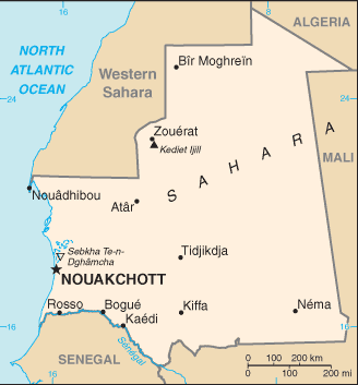
To activate Street View on any city of Mauritania, drag above the Zoom feature the yellow little man in the map.
Facts about Mauritania
| Administrative divisions: | 12 regions (regions , singular - region) and 1 capital district*; Adrar , Assaba , Brakna , Dakhlet Nouadhibou , Gorgol , Guidimaka , Hodh Ech Chargui , Hodh El Gharbi , Inchiri , Nouakchott* , Tagant , Tiris Zemmour , Trarza |
| Area: | total: 1 ,030 ,700 sq km land: 1 ,030 ,400 sq km water: 300 sq km |
| Background: | Independent from France in 1960 , Mauritania annexed the southern third of the former Spanish Sahara (now Western Sahara) in 1976 , but relinquished it after three years of raids by the Polisario guerrilla front seeking independence for the territory. Maaouya Ould Sid Ahmed TAYA seized power in a coup in 1984 and ruled Mauritania with a heavy hand for over two decades. A series of presidential elections that he held were widely seen as flawed. A bloodless coup in August 2005 deposed President TAYA and ushered in a military council that oversaw a transition to democratic rule. Independent candidate Sidi Ould Cheikh ABDALLAHI was inaugurated in April 2007 as Mauritania's first freely and fairly elected president. His term ended prematurely in August 2008 when a coup deposed him and ushered in a military council government. Meanwhile , the country continues to experience ethnic tensions among its black population (Afro-Mauritanians) and White and Black Moor (Arab-Berber) communities. |
| Flag description: | green with a yellow five-pointed star above a yellow , horizontal crescent; the closed side of the crescent is down; the crescent , star , and color green are traditional symbols of Islam |
| Capital: | name: Nouakchott geographic coordinates: 18 07 N , 16 02 W time difference: UTC 0 (5 hours ahead of Washington , DC during Standard Time) |
| Climate: | desert; constantly hot , dry , dusty |
| Currency code: | ouguiya (MRO) |
| Ethnic groups: | mixed Moor/black 40% , Moor 30% , black 30% |
| Geographic coordinates: | 20 00 N , 12 00 W |
| Geography note: | most of the population concentrated in the cities of Nouakchott and Nouadhibou and along the Senegal River in the southern part of the country |
| Government type: | Democratic Republic |
| Imports partners: | France 16.7% , China 8.2% , Spain 6.8% , US 6.2% , Belgium 5.8% , Brazil 5.5% (2007) |
| Internet country code: | .mr |
| Land boundaries: | 754 km |
| Neighbouring countries: | total: 5 ,074 km border countries: Algeria 463 km , Mali 2 ,237 km , Senegal 813 km , Western Sahara 1 ,561 km |
| Languages: | Arabic (official and national) , Pulaar , Soninke , Wolof (all national languages) , French , Hassaniya |
| Location: | Northern Africa , bordering the North Atlantic Ocean , between Senegal and Western Sahara |
| Map references: | Africa |
| National holiday: | Independence Day , 28 November (1960) |
| Nationality: | noun: Mauritanian(s) adjective: Mauritanian |
| Natural hazards: | hot , dry , dust/sand-laden sirocco wind blows primarily in March and April; periodic droughts |
| Population: | 3 ,364 ,940 (July 2008 est.) |
| Religions: | Muslim 100% |
| Terrain: | mostly barren , flat plains of the Sahara; some central hills |
| Unemployment rate: | 20% (2004 est.) |
Capital of Islamic Republic of Mauritania
Nouakchott (click to view Nouakchott map)
Places in Mauritania
Browse the most comprehensive and up-to-date online directory of administrative regions and Street Views in Mauritania. Our listings are organized alphabetically, starting from level 1 regions and progressing through to level 2 and eventually level 3 regions, ensuring you can easily navigate and find specific areas of interest.
Assaba Region (106 google map locations)
Brakna Region (112 google map locations)
Dakhlet Nouadhibou Region (10 google map locations)
Gorgol Region (184 google map locations)
Guidimaka Region (175 google map locations)
Hodh El Gharbi Region (85 google map locations)
Inchiri Region (3 google map locations)
Tagant Region (10 google map locations)
Tiris Zemmour Region (7 google map locations)
Trarza Region (60 google map locations)
Random cities in Mauritania
Nouakchott, the capital city of Mauritania.Ouro Haïré
Dabaï Mbaré
Mboto
Koro
Louboéré
Dios
Néré Oualo
Ouédamor
Bouly
Tiénidébé
Tiali
Vindé Mbordi
Tîchilît Ahel Baba
Tjidé
Jreïda
Vindé Guibi
Dahalagué
Djowol
Lemrhada
Link to Mauritania Google Maps page
The map of Mauritania has already attracted 4078 views. If you wish to embed our comprehensive Mauritania map on your site, we offer an easy solution. This map includes free access to Google Maps, gazetteer search, detailed country and city maps, Street View, and essential facts, all ready to enhance your website. To use it, simply copy and paste the provided HTML code into your webpage's source code. We appreciate every link back to our Maps and Driving Directions. Thank you for your support!
| Text link to: Mauritania map and facts page |
This Mauritania map is intended solely for informational purposes. No representations or warranties are made concerning its accuracy or reliability. Users assume all risks associated with the use of Google Maps and Google Driving Directions. World Route Planner is not liable for any losses or delays that may occur from using this free Mauritania map.