 Republic of Mozambique Google Maps and Facts
Welcome to the Google Maps of Mozambique (MZ) and the comprehensive location list for this country. World Route Planner, together with its detailed Mozambique page, turns Google Maps Sightseeing into a meaningful experience! Our extensive destination gazetteer, coupled with Driving Directions to Mozambique, allows you to explore Mozambique through detailed satellite imagery and street views—fast, free, and easier than ever before.
Browse through the list of administrative regions in Mozambique, navigate through these regions to find a place of interest, and book your hotel with the Best Price Guarantee! Your journey through Mozambique via Google Satellite Map Sightseeing and Street View starts here.
Mozambique Google Maps
To activate Street View on any city of Mozambique, drag above the Zoom feature the yellow little man in the map.
Facts about Mozambique
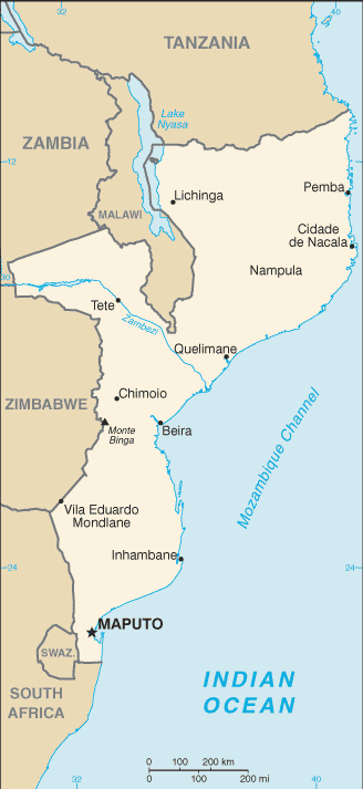
| Administrative divisions: | 10 provinces (provincias , singular - provincia) , 1 city (cidade)*; Cabo Delgado , Gaza , Inhambane , Manica , Maputo , Cidade de Maputo* , Nampula , Niassa , Sofala , Tete , Zambezia |
| Area: | total: 801 ,590 sq km land: 784 ,090 sq km water: 17 ,500 sq km |
| Background: | Almost five centuries as a Portuguese colony came to a close with independence in 1975. Large-scale emigration by whites , economic dependence on South Africa , a severe drought , and a prolonged civil war hindered the country's development until the mid 1990's. The ruling Front for the Liberation of Mozambique (FRELIMO) party formally abandoned Marxism in 1989 , and a new constitution the following year provided for multiparty elections and a free market economy. A UN-negotiated peace agreement between FRELIMO and rebel Mozambique National Resistance (RENAMO) forces ended the fighting in 1992. In December 2004 , Mozambique underwent a delicate transition as Joaquim CHISSANO stepped down after 18 years in office. His elected successor , Armando Emilio GUEBUZA , promised to continue the sound economic policies that have encouraged foreign investment. Mozambique has seen very strong economic growth since the end of the civil war largely due to post-conflict reconstruction. |
| Flag description: | three equal horizontal bands of green (top) , black , and yellow with a red isosceles triangle based on the hoist side; the black band is edged in white; centered in the triangle is a yellow five-pointed star bearing a crossed rifle and hoe in black superimposed on an open white book |
| Capital: | name: Maputo geographic coordinates: 25 57 S , 32 35 E time difference: UTC+2 (7 hours ahead of Washington , DC during Standard Time) |
| Climate: | tropical to subtropical |
| Currency code: | metical (MZM) |
| Ethnic groups: | African 99.66% (Makhuwa , Tsonga , Lomwe , Sena , and others) , Europeans 0.06% , Euro-Africans 0.2% , Indians 0.08% |
| Geographic coordinates: | 18 15 S , 35 00 E |
| Geography note: | the Zambezi flows through the north-central and most fertile part of the country |
| Government type: | republic |
| Imports partners: | South Africa 38.1% , Australia 5.9% , China 4.8% (2007) |
| Internet country code: | .mz |
| Land boundaries: | 2 ,470 km |
| Neighbouring countries: | total: 4 ,571 km border countries: Malawi 1 ,569 km , South Africa 491 km , Swaziland 105 km , Tanzania 756 km , Zambia 419 km , Zimbabwe 1 ,231 km |
| Languages: | Emakhuwa 26.1% , Xichangana 11.3% , Portuguese 8.8% (official; spoken by 27% of population as a second language) , Elomwe 7.6% , Cisena 6.8% , Echuwabo 5.8% , other Mozambican languages 32% , other foreign languages 0.3% , unspecified 1.3% (1997 census) |
| Location: | Southeastern Africa , bordering the Mozambique Channel , between South Africa and Tanzania |
| Map references: | Africa |
| National holiday: | Independence Day , 25 June (1975) |
| Nationality: | noun: Mozambican(s) adjective: Mozambican |
| Natural hazards: | severe droughts; devastating cyclones and floods in central and southern provinces |
| Population: | 21 ,284 ,700 note: estimates for this country explicitly take into account the effects of excess mortality due to AIDS; this can result in lower life expectancy , higher infant mortality , higher death rates , lower population growth rates , and changes in the distribution of population by age and sex than would otherwise be expected; the 1997 Mozambican census reported a population of 16 ,099 ,246 (July 2008 est.) |
| Religions: | Catholic 23.8% , Muslim 17.8% , Zionist Christian 17.5% , other 17.8% , none 23.1% (1997 census) |
| Terrain: | mostly coastal lowlands , uplands in center , high plateaus in northwest , mountains in west |
| Unemployment rate: | 21% (1997 est.) |
Capital of Republic of Mozambique
Maputo (click to view Maputo map)
Places in Mozambique
Browse the most comprehensive and up-to-date online directory of administrative regions and Street Views in Mozambique. Our listings are organized alphabetically, starting from level 1 regions and progressing through to level 2 and eventually level 3 regions, ensuring you can easily navigate and find specific areas of interest.
Gaza Province (1879 google map locations)
Inhambane Province (3158 google map locations)
Manica Province (1186 google map locations)
Maputo City (13 google map locations)
Maputo Province (1559 google map locations)
Niassa Province (1466 google map locations)
Sofala Province (1236 google map locations)
Tete Province (1282 google map locations)
Zambezia Province (2427 google map locations)
Random cities in Mozambique
Maputo, the capital city of Mozambique.Coleti
Chefe Adelino
Sonamanga
Metequenha
Rodrigues
Barada
Moda
Tavira
Selemante
Nantecula
S. Jose
Munguene
Mugametane
Chiuleque
Charamatane
Jeperene
Buesanho
Nicuata
Chefe Muatuca
Link to Mozambique Google Maps page
The map of Mozambique has already attracted 6019 views. If you wish to embed our comprehensive Mozambique map on your site, we offer an easy solution. This map includes free access to Google Maps, gazetteer search, detailed country and city maps, Street View, and essential facts, all ready to enhance your website. To use it, simply copy and paste the provided HTML code into your webpage's source code. We appreciate every link back to our Maps and Driving Directions. Thank you for your support!
| Text link to: Mozambique map and facts page |
This Mozambique map is intended solely for informational purposes. No representations or warranties are made concerning its accuracy or reliability. Users assume all risks associated with the use of Google Maps and Google Driving Directions. World Route Planner is not liable for any losses or delays that may occur from using this free Mozambique map.