 Reunion Google Maps and Facts
Welcome to the Google Maps of Reunion (RE) and the comprehensive location list for this country. World Route Planner, together with its detailed Reunion page, turns Google Maps Sightseeing into a meaningful experience! Our extensive destination gazetteer, coupled with Driving Directions to Reunion, allows you to explore Reunion through detailed satellite imagery and street views—fast, free, and easier than ever before.
Browse through the list of administrative regions in Reunion, navigate through these regions to find a place of interest, and book your hotel with the Best Price Guarantee! Your journey through Reunion via Google Satellite Map Sightseeing and Street View starts here.
Reunion Google Maps
To activate Street View on any city of Reunion, drag above the Zoom feature the yellow little man in the map.
Facts about Reunion
| Administrative divisions: | |
| Area: | |
| Background: | |
| Flag description: | |
| Capital: | |
| Climate: | |
| Currency code: | |
| Ethnic groups: | |
| Geographic coordinates: | |
| Geography note: | |
| Government type: | |
| Imports partners: | |
| Internet country code: | |
| Land boundaries: | |
| Neighbouring countries: | |
| Languages: | |
| Location: | |
| Map references: | |
| National holiday: | |
| Nationality: | |
| Natural hazards: | |
| Population: | |
| Religions: | |
| Terrain: | |
| Unemployment rate: |
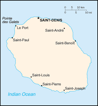
Capital of Reunion
Saint-Denis (click to view Saint-Denis map)
Places in Reunion
Browse the most comprehensive and up-to-date online directory of administrative regions and Street Views in Reunion. Our listings are organized alphabetically, starting from level 1 regions and progressing through to level 2 and eventually level 3 regions, ensuring you can easily navigate and find specific areas of interest.
Abondance city Google map
Aloès city Google map
Anse city Google map
Anse-les Bas city Google map
Anse-les Hauts city Google map
Aurélien Dijoux city Google map
Aurère city Google map
Avenir city Google map
Bagatelle city Google map
Bain city Google map
Baril city Google map
Basse Vallée city Google map
Bassin Martin city Google map
Bé Cabot city Google map
Beaufond city Google map
Beaufonds city Google map
Beaulieu city Google map
Beaumont city Google map
Beauvallon city Google map
Bebour city Google map
Bel Air city Google map
Bellemène city Google map
Bellevue city Google map
Bérive city Google map
Bérive-les Bas city Google map
Bernica-les Bas city Google map
Bethléem city Google map
Bois Court city Google map
Bois de Nèfles city Google map
Bois d'Olive city Google map
Bois-Blanc city Google map
Bois-Rouge city Google map
Boucan Canot city Google map
Bourbier city Google map
Bout de l'Étang city Google map
Bras Canot city Google map
Bras de Ponteau city Google map
Bras des Calumets city Google map
Bras des Chevrettes city Google map
Bras Madeleine city Google map
Bras-Panon city Google map
Cafrine city Google map
Cambuston city Google map
Camp de Pierrot city Google map
Camp Jacquot city Google map
Cap Blanc city Google map
Cap Noir city Google map
Carosse city Google map
Casabona city Google map
Cascades city Google map
Champ-Borne city Google map
Chemin César city Google map
Chiendent city Google map
Cilaos city Google map
Commune Ango city Google map
Commune Bègue city Google map
Commune Carron city Google map
Condé city Google map
Confiance city Google map
Convenance city Google map
Desbassyns city Google map
Désert city Google map
Dimitile city Google map
Domenjod city Google map
Dos d'Âne city Google map
Entre-Deux city Google map
Espérance city Google map
Étang city Google map
Étang-les Hauts city Google map
Étang-Salé city Google map
Étang-Salé les Bains city Google map
F. Sauger city Google map
Fiague city Google map
Filaos city Google map
Flacourt city Google map
Fleurimont city Google map
Fleurs Jaunes-les Hauts city Google map
Franche Terre city Google map
Gillot city Google map
Girofle city Google map
Gôl city Google map
Gôl-le Haut city Google map
Grand Bassin city Google map
Grand Coude city Google map
Grand Fond city Google map
Grand Galet city Google map
Grand Îlet city Google map
Grande Anse city Google map
Grande Place city Google map
Grande Ravine city Google map
Grands Bois city Google map
Halte-là city Google map
Harmonie city Google map
Hell-Bourg city Google map
Îlet à Cordes city Google map
Îlet à Déjeuner city Google map
Îlet à Guillaume city Google map
Îlet à Malheur city Google map
Îlet à Vidot city Google map
Îlet Bois-Rouge city Google map
Îlet de Roche Plate city Google map
Îlet Denise city Google map
Îlet des Lataniers city Google map
Îlet du Peter-Boot city Google map
Îlet Flamand city Google map
Îlet Marron city Google map
Îlet Morin city Google map
Îlet Nourry city Google map
Îlet Ronde city Google map
Îlet Solitude city Google map
Îlet Techer city Google map
Îlet Tommic city Google map
Jacques Payet city Google map
Jean Petit city Google map
Jean Petit-les Bas city Google map
La Bretagne city Google map
La Butte city Google map
La Caroline city Google map
La Chaloupe Saint-Leu city Google map
La Chatoire city Google map
La Crête city Google map
La Croix city Google map
La Fontaine city Google map
La Fontaine-les Hauts city Google map
La Goyave city Google map
La Grande Chaloupe city Google map
La Grande Montée city Google map
La Mare city Google map
La Marine city Google map
La Montagne city Google map
La Nouvelle city Google map
La Paix city Google map
La Passarelle city Google map
La Petite Île city Google map
La Plaine city Google map
La Plaine des Cafres city Google map
La Plaine des Palmistes city Google map
La Pointe city Google map
La Possession city Google map
La Providence city Google map
La Renaissance city Google map
La Ressource city Google map
La Rivière city Google map
La Rivière des Pluies city Google map
La Rivière des Roches city Google map
La Saline city Google map
La Saline-les Bas city Google map
La Vallée city Google map
La Vigne city Google map
Langevin city Google map
Le Barrage city Google map
Le Bélier city Google map
Le Bésave city Google map
Le Bois de Nèfles city Google map
Le Bras Creux city Google map
Le Brûlé city Google map
Le Butor city Google map
Le Cap city Google map
Le Cap-les Hauts city Google map
Le Cazabois city Google map
Le Coeur Saignant city Google map
Le Colosse city Google map
Le Cratère city Google map
Le Délice city Google map
Le Dioré city Google map
Le Dix-Neuvième city Google map
Le Dix-Septième city Google map
Le Fond de Maurice city Google map
Le Guillaume city Google map
Le Lambert city Google map
Le Maniron city Google map
Le Onzième city Google map
Le Ouaki city Google map
Le Patelin city Google map
Le Pavillon city Google map
Le Petit Brûlé city Google map
Le Petit Tampon city Google map
Le Port city Google map
Le Portail city Google map
Le Pourpier city Google map
Le Quatorzième city Google map
Le Ramier city Google map
Le Rond city Google map
Le Ruisseau city Google map
Le Tampon city Google map
Le Tévelave city Google map
Le Titan city Google map
Les Aigrettes city Google map
Les Avirons city Google map
Les Camélias city Google map
Les Canots city Google map
Les Chicots city Google map
Les Cocos city Google map
Les Colimaçons city Google map
Les Deux Bras city Google map
Les Jacques city Google map
Les Lianes city Google map
Les Orangers city Google map
Les Quatre-Cents city Google map
Les Sables Blancs city Google map
Les Six-Cents city Google map
Les Trois Frères city Google map
Les Trois Mares city Google map
Les Vacoas city Google map
Ligne des Bambous city Google map
L'Éperon city Google map
L'Escalier city Google map
L'Étang city Google map
L'Hermitage city Google map
L'Hermitage-les Bas city Google map
L'Îlet city Google map
L'Îlet aux Palmistes city Google map
L'Oasis city Google map
M. Lamotte city Google map
Ma Pensée city Google map
Mafatte city Google map
Mahavel city Google map
Maison de l'Enfance city Google map
Maison Henou city Google map
Maison Isautier city Google map
Maison James Biget city Google map
Maison Lelièvre city Google map
Maison Leroux city Google map
Maison Moullan city Google map
Maison Payet city Google map
Maison Rouge city Google map
Makes city Google map
Manapany city Google map
Manapany-les Bains city Google map
Manapany-les Hauts city Google map
Mare à Citrons city Google map
Mare à Vieille Place city Google map
Mare Longue city Google map
Marepine city Google map
Matouta city Google map
Menciol city Google map
Moka city Google map
Mon Caprice city Google map
Monrepos city Google map
Montvert-les Bas city Google map
Montvert-les Hauts city Google map
Morange city Google map
Petit Bazar city Google map
Petit Sable city Google map
Petit Saint-Pierre city Google map
Petit Serré city Google map
Petite Île city Google map
Petite Ravine city Google map
Pichète city Google map
Pierrefonds city Google map
Piton city Google map
Piton Sainte-Rose city Google map
Plaine des Grègues city Google map
Plate city Google map
Pont Dives city Google map
Quartier-Français city Google map
Ravine à Malheur city Google map
Ravine à Marquet city Google map
Ravine Blanche city Google map
Ravine Creuse city Google map
Ravine des Cabris city Google map
Ravine des Cafres-les Bas city Google map
Ravine des Cafres-les Hauts city Google map
Ravine des Chèvres city Google map
Ravine des Chèvres-les Hauts city Google map
Ravine du Pont city Google map
Ravine du Pont-les Bas city Google map
Ravine d'Ango city Google map
Ravine Glissante city Google map
Ravine Martin city Google map
Ravine Sèche city Google map
Renaissance city Google map
Réunion city Google map
Révolution city Google map
Rivière city Google map
Rivière de l'Est city Google map
Rivière du Mât-les Bas city Google map
Rivière du Mât-les Hauts city Google map
Rivière du Rempart city Google map
Rivière Saint-Pierre city Google map
Roche Maigre city Google map
Saint-André city Google map
Saint-Benoît city Google map
Saint-Bernard city Google map
Saint-Denis city Google map
Saint-François city Google map
Saint-Gilles-les Bains city Google map
Saint-Gilles-les Hauts city Google map
Saint-Joseph city Google map
Saint-Leu city Google map
Saint-Louis city Google map
Saint-Paul city Google map
Saint-Philippe city Google map
Saint-Pierre city Google map
Sainte-Anne city Google map
Sainte-Anne-les Hauts city Google map
Sainte-Clotilde city Google map
Sainte-Marie city Google map
Sainte-Rose city Google map
Sainte-Suzanne city Google map
Sainte-Thérèse city Google map
Salazie city Google map
Saline-les Hauts city Google map
Savannah city Google map
Sous les Bois Noirs city Google map
Stella Matutina city Google map
Surprise city Google map
Takamaka city Google map
Terre Rouge city Google map
Terre Sainte city Google map
Tremblet city Google map
Trinité city Google map
Trois Bassins city Google map
Trois Mares-les Hauts city Google map
Union city Google map
Verger Hemery city Google map
Village du Piton city Google map
Vincendo city Google map
Vue Belle city Google map
Random cities in Reunion
Saint-Denis, the capital city of Reunion.Saint-Benoît
Gôl-le Haut
Le Dioré
Jean Petit-les Bas
Le Barrage
Îlet Denise
La Plaine des Cafres
Bois-Blanc
Le Ouaki
Franche Terre
Les Sables Blancs
Le Chaudron
Grande Anse
Camp Jacquot
Le Portail
Domenjod
Les Six-Cents
Bain
La Fontaine-les Hauts
Link to Reunion Google Maps page
The map of Reunion has already attracted 4957 views. If you wish to embed our comprehensive Reunion map on your site, we offer an easy solution. This map includes free access to Google Maps, gazetteer search, detailed country and city maps, Street View, and essential facts, all ready to enhance your website. To use it, simply copy and paste the provided HTML code into your webpage's source code. We appreciate every link back to our Maps and Driving Directions. Thank you for your support!
| Text link to: Reunion map and facts page |
This Reunion map is intended solely for informational purposes. No representations or warranties are made concerning its accuracy or reliability. Users assume all risks associated with the use of Google Maps and Google Driving Directions. World Route Planner is not liable for any losses or delays that may occur from using this free Reunion map.