 Saint Helena Google Maps and Facts
Welcome to the Google Maps of Saint Helena (SH) and the comprehensive location list for this country. World Route Planner, together with its detailed Saint Helena page, turns Google Maps Sightseeing into a meaningful experience! Our extensive destination gazetteer, coupled with Driving Directions to Saint Helena, allows you to explore Saint Helena through detailed satellite imagery and street views—fast, free, and easier than ever before.
Browse through the list of administrative regions in Saint Helena, navigate through these regions to find a place of interest, and book your hotel with the Best Price Guarantee! Your journey through Saint Helena via Google Satellite Map Sightseeing and Street View starts here.
Saint Helena Google Maps
To activate Street View on any city of Saint Helena, drag above the Zoom feature the yellow little man in the map.
Facts about Saint Helena
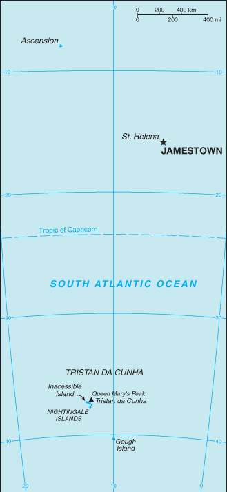
| Administrative divisions: | 1 administrative area and 2 dependencies*; Ascension* , Saint Helena , Tristan da Cunha* |
| Area: | total: 413 sq km land: Saint Helena Island 122 sq km; Ascension Island 90 sq km; Tristan da Cunha island group 201 sq km water: 0 sq km |
| Background: | Saint Helena is a British Overseas Territory consisting of Saint Helena and Ascension Islands , and the island group of Tristan da Cunha. Saint Helena: Uninhabited when first discovered by the Portuguese in 1502 , Saint Helena was garrisoned by the British during the 17th century. It acquired fame as the place of Napoleon BONAPARTE's exile , from 1815 until his death in 1821 , but its importance as a port of call declined after the opening of the Suez Canal in 1869. During the Anglo-Boer War in South Africa , several thousand Boer prisoners were confined on the island between 1900 and 1903. Ascension Island: This barren and uninhabited island was discovered and named by the Portuguese in 1503. The British garrisoned the island in 1815 to prevent a rescue of Napoleon from Saint Helena and it served as a provisioning station for the Royal Navy's West Africa Squadron on anti-slavery patrol. The island remained under Admiralty control until 1922 , when it became a dependency of Saint Helena. During World War II , the UK permitted the US to construct an airfield on Ascension in support of trans-Atlantic flights to Africa and anti-submarine operations in the South Atlantic. In the 1960s the island became an important space tracking station for the US. In 1982 , Ascension was an essential staging area for British forces during the Falklands War , and it remains a critical refueling point in the air-bridge from the UK to the South Atlantic. Tristan da Cunha: The island group consists of the islands of Tristan da Cunha , Nightingale , Inaccessible , and Gough. Tristan da Cunha is named after its Portuguese discoverer (1506); it was garrisoned by the British in 1816 to prevent any attempt to rescue Napoleon from Saint Helena. Gough and Inaccessible Islands have been designated World Heritage Sites. South Africa leases a site for a meteorological station on Gough Island. |
| Flag description: | blue with the flag of the UK in the upper hoist-side quadrant and the Saint Helenian shield centered on the outer half of the flag; the shield features a rocky coastline and three-masted sailing ship |
| Capital: | name: Jamestown geographic coordinates: 15 56 S , 5 44 W time difference: UTC 0 (5 hours ahead of Washington , DC during Standard Time) |
| Climate: | Saint Helena: tropical marine; mild , tempered by trade winds Ascension Island: tropical marine; mild , semi-arid Tristan da Cunha: temperate marine; mild , tempered by trade winds (tends to be cooler than Saint Helena) |
| Currency code: | |
| Ethnic groups: | African descent 50% , white 25% , Chinese 25% |
| Geographic coordinates: | Saint Helena: 15 57 S , 5 42 W Ascension Island: 7 57 S , 14 22 W Tristan da Cunha island group: 37 15 S , 12 30 W |
| Geography note: | Saint Helena harbors at least 40 species of plants unknown anywhere else in the world; Ascension is a breeding ground for sea turtles and sooty terns; Queen Mary's Peak on Tristan da Cunha is the highest island mountain in the South Atlantic and a prominent landmark on the sea lanes around southern Africa |
| Government type: | NA |
| Imports partners: | UK 53.5% , South Africa 14.3% , Spain 10.3% , Tanzania 8.5% , US 4.6% (2006) |
| Internet country code: | .sh; note - Ascension Island assigned .ac |
| Land boundaries: | Saint Helena: 60 km Ascension Island: NA Tristan da Cunha: 40 km |
| Neighbouring countries: | 0 km |
| Languages: | English |
| Location: | islands in the South Atlantic Ocean , about midway between South America and Africa; Ascension Island lies 700 nm northwest of Saint Helena; Tristan da Cunha lies 2300 nm southwest of Saint Helena |
| Map references: | Africa |
| National holiday: | Birthday of Queen ELIZABETH II , second Saturday in June (1926) |
| Nationality: | noun: Saint Helenian(s) adjective: Saint Helenian note: referred to locally as "Saints" |
| Natural hazards: | active volcanism on Tristan da Cunha , last eruption in 1961 |
| Population: | 7 ,601 note: only Saint Helena , Ascension , and Tristan da Cunha islands are inhabited (July 2008 est.) |
| Religions: | Anglican (majority) , Baptist , Seventh-Day Adventist , Roman Catholic |
| Terrain: | the islands of this group result from volcanic activity associated with the Atlantic Mid-Ocean Ridge Saint Helena: rugged , volcanic; small scattered plateaus and plains Ascension: surface covered by lava flows and cinder cones of 44 dormant volcanoes; ground rises to the east Tristan da Cunha: sheer cliffs line the coastline of the nearly circular island; the flanks of the central volcanic peak are deeply dissected; narrow coastal plain lies between The Peak and the coastal cliffs |
| Unemployment rate: | 14% (1998 est.) |
Capital of Saint Helena
Jamestown (click to view Jamestown map)
Places in Saint Helena
Browse the most comprehensive and up-to-date online directory of administrative regions and Street Views in Saint Helena. Our listings are organized alphabetically, starting from level 1 regions and progressing through to level 2 and eventually level 3 regions, ensuring you can easily navigate and find specific areas of interest.
Edinburgh city Google map
Georgetown city Google map
Half Tree Hollow city Google map
Hutts Gate city Google map
Jamestown city Google map
Levelwood city Google map
New Ground city Google map
Taglate city Google map
Thornton city Google map
Two Boats Village city Google map
Wild Cattle Pound city Google map
Random cities in Saint Helena
Jamestown, the capital city of Saint Helena.Georgetown
New Ground
Edinburgh
Levelwood
Hutts Gate
Wild Cattle Pound
Deadwood
Thornton
Taglate
Two Boats Village
Half Tree Hollow
Longwood
Link to Saint Helena Google Maps page
The map of Saint Helena has already attracted 3123 views. If you wish to embed our comprehensive Saint Helena map on your site, we offer an easy solution. This map includes free access to Google Maps, gazetteer search, detailed country and city maps, Street View, and essential facts, all ready to enhance your website. To use it, simply copy and paste the provided HTML code into your webpage's source code. We appreciate every link back to our Maps and Driving Directions. Thank you for your support!
| Text link to: Saint Helena map and facts page |
This Saint Helena map is intended solely for informational purposes. No representations or warranties are made concerning its accuracy or reliability. Users assume all risks associated with the use of Google Maps and Google Driving Directions. World Route Planner is not liable for any losses or delays that may occur from using this free Saint Helena map.