 Democratic Republic of Sao Tome and Principe Google Maps and Facts
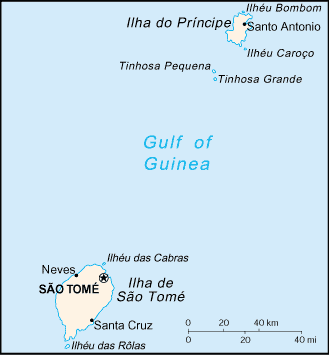
Map of Sao Tome and Principe ⇣ | Google Maps of Sao Tome and Principe ⇣ | All Places in Sao Tome and Principe ⇣
Welcome to the Google Maps of Sao Tome and Principe (ST) and the comprehensive location list for this country. World Route Planner, together with its detailed Sao Tome and Principe page, turns Google Maps Sightseeing into a meaningful experience! Our extensive destination gazetteer, coupled with Driving Directions to Sao Tome and Principe, allows you to explore Sao Tome and Principe through detailed satellite imagery and street views—fast, free, and easier than ever before.
Browse through the list of administrative regions in Sao Tome and Principe, navigate through these regions to find a place of interest, and book your hotel with the Best Price Guarantee! Your journey through Sao Tome and Principe via Google Satellite Map Sightseeing and Street View starts here.
Sao Tome and Principe Google Maps
To activate Street View on any city of Sao Tome and Principe, drag above the Zoom feature the yellow little man in the map.
Facts about Sao Tome and Principe
| Administrative divisions: | 2 provinces; Principe , Sao Tome note: Principe has had self government since 29 April 1995 |
| Area: | total: 1 ,001 sq km land: 1 ,001 sq km water: 0 sq km |
| Background: | Discovered and claimed by Portugal in the late 15th century , the islands' sugar-based economy gave way to coffee and cocoa in the 19th century - all grown with plantation slave labor , a form of which lingered into the 20th century. While independence was achieved in 1975 , democratic reforms were not instituted until the late 1980s. The country held its first free elections in 1991 , but frequent internal wrangling between the various political parties precipitated repeated changes in leadership and two failed coup attempts in 1995 and 2003. The recent discovery of oil in the Gulf of Guinea promises to attract increased attention to the small island nation. |
| Flag description: | three horizontal bands of green (top) , yellow (double width) , and green with two black five-pointed stars placed side by side in the center of the yellow band and a red isosceles triangle based on the hoist side; uses the popular pan-African colors of Ethiopia |
| Capital: | name: Sao Tome geographic coordinates: 0 12 N , 6 39 E time difference: UTC 0 (5 hours ahead of Washington , DC during Standard Time) |
| Climate: | tropical; hot , humid; one rainy season (October to May) |
| Currency code: | |
| Ethnic groups: | mestico , angolares (descendants of Angolan slaves) , forros (descendants of freed slaves) , servicais (contract laborers from Angola , Mozambique , and Cape Verde) , tongas (children of servicais born on the islands) , Europeans (primarily Portuguese) |
| Geographic coordinates: | 1 00 N , 7 00 E |
| Geography note: | the smallest country in Africa; the two main islands form part of a chain of extinct volcanoes and both are mountainous |
| Government type: | republic |
| Imports partners: | Portugal 60.5% , US 11.2% , Gabon 4.3% (2007) |
| Internet country code: | .st |
| Land boundaries: | 209 km |
| Neighbouring countries: | 0 km |
| Languages: | Portuguese (official) |
| Location: | Western Africa , islands in the Gulf of Guinea , straddling the Equator , west of Gabon |
| Map references: | Africa |
| National holiday: | Independence Day , 12 July (1975) |
| Nationality: | noun: Sao Tomean(s) adjective: Sao Tomean |
| Natural hazards: | NA |
| Population: | 206 ,178 (July 2008 est.) |
| Religions: | Catholic 70.3% , Evangelical 3.4% , New Apostolic 2% , Adventist 1.8% , other 3.1% , none 19.4% (2001 census) |
| Terrain: | volcanic , mountainous |
| Unemployment rate: | NA% |
Capital of Democratic Republic of Sao Tome and Principe
São Tomé (click to view São Tomé map)
Places in Sao Tome and Principe
Browse the most comprehensive and up-to-date online directory of administrative regions and Street Views in Sao Tome and Principe. Our listings are organized alphabetically, starting from level 1 regions and progressing through to level 2 and eventually level 3 regions, ensuring you can easily navigate and find specific areas of interest.
Random cities in Sao Tome and Principe
São Tomé, the capital city of Sao Tome and Principe.Saudade
São Francisco
Santa Isabel
Santa Elvira
Praia da Rosema
Cadão
Monte Rosa
Nova Moca
Caldeiras
Uba
Bombon
Matocana
Pau Cavalo
Oquê Gaspar
São Januário
Santa Trindade
São João
Nova Cuba
Diana
Link to Sao Tome and Principe Google Maps page
The map of Sao Tome and Principe has already attracted 3601 views. If you wish to embed our comprehensive Sao Tome and Principe map on your site, we offer an easy solution. This map includes free access to Google Maps, gazetteer search, detailed country and city maps, Street View, and essential facts, all ready to enhance your website. To use it, simply copy and paste the provided HTML code into your webpage's source code. We appreciate every link back to our Maps and Driving Directions. Thank you for your support!
| Text link to: Sao Tome and Principe map and facts page |
This Sao Tome and Principe map is intended solely for informational purposes. No representations or warranties are made concerning its accuracy or reliability. Users assume all risks associated with the use of Google Maps and Google Driving Directions. World Route Planner is not liable for any losses or delays that may occur from using this free Sao Tome and Principe map.