 Kingdom of Cambodia Google Maps and Facts
Welcome to the Google Maps of Cambodia (KH) and the comprehensive location list for this country. World Route Planner, together with its detailed Cambodia page, turns Google Maps Sightseeing into a meaningful experience! Our extensive destination gazetteer, coupled with Driving Directions to Cambodia, allows you to explore Cambodia through detailed satellite imagery and street views—fast, free, and easier than ever before.
Browse through the list of administrative regions in Cambodia, navigate through these regions to find a place of interest, and book your hotel with the Best Price Guarantee! Your journey through Cambodia via Google Satellite Map Sightseeing and Street View starts here.
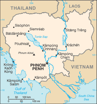
Cambodia Google Maps
To activate Street View on any city of Cambodia, drag above the Zoom feature the yellow little man in the map.
<h3>Did you know about Cambodia?</h3> Cambodia is located in the southern part of the Indochina Peninsula. The area that is present-day Cambodia came under Khmer rule around the year 600 AD, when the region was at the centre of a vast empire that stretched over most of Southeast Asia. Under the Khmers, a magnificent temple complex was constructed at Angkor. This beautiful, fertile land has beenthe scene of many conflicts, and this legacy has left it a poor country. Angkor Wat, in Siem Reap, Cambodia, is the largest religious templein the world.
Facts about Cambodia
| Administrative divisions: | 20 provinces (khaitt , singular and plural) and 4 municipalities* (krong , singular and plural) provinces: Banteay Mean Cheay , Batdambang , Kampong Cham , Kampong Chhnang , Kampong Spoe , Kampong Thum , Kampot , Kandal , Kaoh Kong , Krachen , Mondol Kiri , Otdar Mean Cheay , Pouthisat , Preah Vihear , Prey Veng , Rotanah Kiri , Siem Reab , Stoeng Treng , Svay Rieng , Takev municipalities: Keb , Pailin , Phnum Penh (Phnom Penh) , Preah Seihanu (Sihanoukville) |
| Area: | total: 181 ,040 sq km land: 176 ,520 sq km water: 4 ,520 sq km |
| Background: | Most Cambodians consider themselves to be Khmers , descendants of the Angkor Empire that extended over much of Southeast Asia and reached its zenith between the 10th and 13th centuries. Attacks by the Thai and Cham (from present-day Vietnam) weakened the empire , ushering in a long period of decline. The king placed the country under French protection in 1863 and it became part of French Indochina in 1887. Following Japanese occupation in World War II , Cambodia gained full independence from France in 1953. In April 1975 , after a five-year struggle , Communist Khmer Rouge forces captured Phnom Penh and evacuated all cities and towns. At least 1.5 million Cambodians died from execution , forced hardships , or starvation during the Khmer Rouge regime under POL POT. A December 1978 Vietnamese invasion drove the Khmer Rouge into the countryside , began a 10-year Vietnamese occupation , and touched off almost 13 years of civil war. The 1991 Paris Peace Accords mandated democratic elections and a ceasefire , which was not fully respected by the Khmer Rouge. UN-sponsored elections in 1993 helped restore some semblance of normalcy under a coalition government. Factional fighting in 1997 ended the first coalition government , but a second round of national elections in 1998 led to the formation of another coalition government and renewed political stability. The remaining elements of the Khmer Rouge surrendered in early 1999. Some of the remaining Khmer Rouge leaders are awaiting trial by a UN-sponsored tribunal for crimes against humanity. Elections in July 2003 were relatively peaceful , but it took one year of negotiations between contending political parties before a coalition government was formed. In October 2004 , King SIHANOUK abdicated the throne due to illness and his son , Prince Norodom SIHAMONI , was selected to succeed him. Local elections were held in Cambodia in April 2007 , and there was little in the way of pre-election violence that preceded prior elections. National elections are scheduled for July 2008. |
| Flag description: | three horizontal bands of blue (top) , red (double width) , and blue with a white three-towered temple representing Angkor Wat outlined in black in the center of the red band note: only national flag to incorporate an actual building in its design |
| Capital: | name: Phnom Penh geographic coordinates: 11 33 N , 104 55 E time difference: UTC+7 (12 hours ahead of Washington , DC during Standard Time) |
| Climate: | tropical; rainy , monsoon season (May to November); dry season (December to April); little seasonal temperature variation |
| Currency code: | riel (KHR) |
| Ethnic groups: | Khmer 90% , Vietnamese 5% , Chinese 1% , other 4% |
| Geographic coordinates: | 13 00 N , 105 00 E |
| Geography note: | a land of paddies and forests dominated by the Mekong River and Tonle Sap |
| Government type: | multiparty democracy under a constitutional monarchy |
| Imports partners: | Thailand 26.9% , China 17.5% , Hong Kong 12.2% , Taiwan 8.8% , Singapore 8.7% , Vietnam 6.1% (2007) |
| Internet country code: | .kh |
| Land boundaries: | 443 km |
| Neighbouring countries: | total: 2 ,572 km border countries: Laos 541 km , Thailand 803 km , Vietnam 1 ,228 km |
| Languages: | Khmer (official) 95% , French , English |
| Location: | Southeastern Asia , bordering the Gulf of Thailand , between Thailand , Vietnam , and Laos |
| Map references: | Southeast Asia |
| National holiday: | Independence Day , 9 November (1953) |
| Nationality: | noun: Cambodian(s) adjective: Cambodian |
| Natural hazards: | monsoonal rains (June to November); flooding; occasional droughts |
| Population: | 14 ,241 ,640 note: estimates for this country take into account the effects of excess mortality due to AIDS; this can result in lower life expectancy , higher infant mortality , higher death rates , lower population growth rates , and changes in the distribution of population by age and sex than would otherwise be expected (July 2008 est.) |
| Religions: | Theravada Buddhist 95% , other 5% |
| Terrain: | mostly low , flat plains; mountains in southwest and north |
| Unemployment rate: | 2.5% (2000 est.) |
Capital of Kingdom of Cambodia
Phnum Pénh (click to view Phnum Pénh map)
Places in Cambodia
Browse the most comprehensive and up-to-date online directory of administrative regions and Street Views in Cambodia. Our listings are organized alphabetically, starting from level 1 regions and progressing through to level 2 and eventually level 3 regions, ensuring you can easily navigate and find specific areas of interest.
Battambang Province (931 google map locations)
Kampong Cham Province (667 google map locations)
Kampong Chhnang Province (398 google map locations)
Kampong Speu Province (499 google map locations)
Kampong Thom Province (529 google map locations)
Kampot Province (447 google map locations)
Kandal Province (461 google map locations)
Khétt Krâchéh (229 google map locations)
Khétt Poŭthĭsăt (388 google map locations)
Mondulkiri Province (138 google map locations)
Phnom Penh (28 google map locations)
Preah Vihear Province (96 google map locations)
Prey Veng Province (515 google map locations)
Ratanakiri Province (170 google map locations)
Stung Treng Province (126 google map locations)
Svay Rieng Province (293 google map locations)
Takéo Province (445 google map locations)
Random cities in Cambodia
Phnum Pénh, the capital city of Cambodia.Phumĭ Krăng Chrânéang
Phumĭ Ta Mŏk
Phumĭ Châmlâng Chrey
Phumĭ Âmpŏu Prey
Phumĭ Véal
Phumĭ Kâmpóng Tréa (1)
Phumĭ Ânsaôm K'êk
Phumĭ Bayab
Phumĭ Tuŏl Kândaôl
Phumĭ Trâpeăng Chhuk
Phumĭ Ban Mai
Phumĭ Ta Aông Pŏk
Phumĭ Trâpeăng Krâkaôh
Phumĭ Kântuŏt Prey
Sala Khŭm Dâmrei Slăb
Phumĭ Rôbós Môngkól
Phumĭ Ta Bŭn
Phumĭ Ta Lón
Phumĭ Dom Khvĕt
Link to Cambodia Google Maps page
The map of Cambodia has already attracted 8110 views. If you wish to embed our comprehensive Cambodia map on your site, we offer an easy solution. This map includes free access to Google Maps, gazetteer search, detailed country and city maps, Street View, and essential facts, all ready to enhance your website. To use it, simply copy and paste the provided HTML code into your webpage's source code. We appreciate every link back to our Maps and Driving Directions. Thank you for your support!
| Text link to: Cambodia map and facts page |
This Cambodia map is intended solely for informational purposes. No representations or warranties are made concerning its accuracy or reliability. Users assume all risks associated with the use of Google Maps and Google Driving Directions. World Route Planner is not liable for any losses or delays that may occur from using this free Cambodia map.