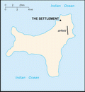
 Territory of Christmas Island Google Maps and Facts
Welcome to the Google Maps of Christmas Island (CX) and the comprehensive location list for this country. World Route Planner, together with its detailed Christmas Island page, turns Google Maps Sightseeing into a meaningful experience! Our extensive destination gazetteer, coupled with Driving Directions to Christmas Island, allows you to explore Christmas Island through detailed satellite imagery and street views—fast, free, and easier than ever before.
Browse through the list of administrative regions in Christmas Island, navigate through these regions to find a place of interest, and book your hotel with the Best Price Guarantee! Your journey through Christmas Island via Google Satellite Map Sightseeing and Street View starts here.
Christmas Island Google Maps
To activate Street View on any city of Christmas Island, drag above the Zoom feature the yellow little man in the map.
Facts about Christmas Island
| Administrative divisions: | none (territory of Australia) |
| Area: | total: 135 sq km land: 135 sq km water: 0 sq km Clipperton Island |
| Background: | Named in 1643 for the day of its discovery , the island was annexed and settlement began by the UK in 1888. Phosphate mining began in the 1890s. The UK transferred sovereignty to Australia in 1958. Almost two-thirds of the island has been declared a national park. Clipperton Island |
| Flag description: | territorial flag; divided diagonally from upper hoist to lower fly; the upper triangle is green with a yellow image of the Golden Bosun Bird superimposed , while the lower triangle is blue with the Southern Cross constellation , representing Australia , superimposed; a centered yellow disk displays a green map of the island note: the flag of Australia is used for official purposes Clipperton Island |
| Capital: | name: The Settlement geographic coordinates: 10 25 S , 105 43 E time difference: UTC+7 (12 hours ahead of Washington , DC during Standard Time) |
| Climate: | tropical with a wet season (December to April) and dry season; heat and humidity moderated by trade winds Clipperton Island |
| Currency code: | Australian dollar (AUD) |
| Ethnic groups: | Chinese 70% , European 20% , Malay 10% note: no indigenous population (2001) |
| Geographic coordinates: | 10 30 S , 105 40 E Clipperton Island |
| Geography note: | located along major sea lanes of Indian Ocean Clipperton Island |
| Government type: | NA |
| Imports partners: | principally Australia (2006) |
| Internet country code: | .cx |
| Land boundaries: | 138.9 km Clipperton Island |
| Neighbouring countries: | 0 km Clipperton Island |
| Languages: | English (official) , Chinese , Malay |
| Location: | Southeastern Asia , island in the Indian Ocean , south of Indonesia Clipperton Island |
| Map references: | Southeast Asia Clipperton Island |
| National holiday: | Australia Day , 26 January (1788) |
| Nationality: | noun: Christmas Islander(s) adjective: Christmas Island |
| Natural hazards: | the narrow fringing reef surrounding the island can be a maritime hazard Clipperton Island |
| Population: | 1 ,402 (July 2007 est.) Clipperton Island |
| Religions: | Buddhist 36% , Muslim 25% , Christian 18% , other 21% (1997) |
| Terrain: | steep cliffs along coast rise abruptly to central plateau Clipperton Island |
| Unemployment rate: |
Capital of Territory of Christmas Island
Flying Fish Cove (click to view Flying Fish Cove map)
Places in Christmas Island
Browse the most comprehensive and up-to-date online directory of administrative regions and Street Views in Christmas Island. Our listings are organized alphabetically, starting from level 1 regions and progressing through to level 2 and eventually level 3 regions, ensuring you can easily navigate and find specific areas of interest.
Random cities in Christmas Island
Flying Fish Cove, the capital city of Christmas Island.Link to Christmas Island Google Maps page
The map of Christmas Island has already attracted 2941 views. If you wish to embed our comprehensive Christmas Island map on your site, we offer an easy solution. This map includes free access to Google Maps, gazetteer search, detailed country and city maps, Street View, and essential facts, all ready to enhance your website. To use it, simply copy and paste the provided HTML code into your webpage's source code. We appreciate every link back to our Maps and Driving Directions. Thank you for your support!
| Text link to: Christmas Island map and facts page |
This Christmas Island map is intended solely for informational purposes. No representations or warranties are made concerning its accuracy or reliability. Users assume all risks associated with the use of Google Maps and Google Driving Directions. World Route Planner is not liable for any losses or delays that may occur from using this free Christmas Island map.
