 Republic of Korea Google Maps and Facts
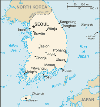
Welcome to the Google Maps of Korea, South (KR) and the comprehensive location list for this country. World Route Planner, together with its detailed Korea, South page, turns Google Maps Sightseeing into a meaningful experience! Our extensive destination gazetteer, coupled with Driving Directions to Korea, South, allows you to explore Korea, South through detailed satellite imagery and street views—fast, free, and easier than ever before.
Browse through the list of administrative regions in Korea, South, navigate through these regions to find a place of interest, and book your hotel with the Best Price Guarantee! Your journey through Korea, South via Google Satellite Map Sightseeing and Street View starts here.
Korea, South Google Maps
To activate Street View on any city of Korea, South, drag above the Zoom feature the yellow little man in the map.
Why was Korea divided?
Korea is an East Asian country that is at present divided into two countries - North Korea and South Korea. But why did this division take place? The Soviet Union occupied the northern half of Korea after World War II ended in 1945. At the same time, Southern Korea was controlled by the United States. The peninsula was formally split in two in 1948. The political differences between the two rival states led to the outbreak of a horrific war in 1950. Three years later, a cease-fire agreement ended the Korean War. Butthe North Koreans and South Koreans have to this day, never signed a peace treaty. South Korea has developed into one of Asia's most affluent countries since partition in 1948. North Korea, on the other hand, has been one of the world's most secretive societies. It is one of the few countries still under nominally communist rule.Facts about Korea, South
| Administrative divisions: | 9 provinces (do , singular and plural) and 7 metropolitan cities (gwangyoksi , singular and plural) provinces: Cheju-do , Cholla-bukto (North Cholla) , Cholla-namdo (South Cholla) , Ch'ungch'ong-bukto (North Ch'ungch'ong) , Ch'ungch'ong-namdo (South Ch'ungch'ong) , Kangwon-do , Kyonggi-do , Kyongsang-bukto (North Kyongsang) , Kyongsang-namdo (South Kyongsang) metropolitan cities: Inch'on-gwangyoksi (Inch'on) , Kwangju-gwangyoksi (Kwangju) , Pusan-gwangyoksi (Pusan) , Soul-t'ukpyolsi (Seoul) , Taegu-gwangyoksi (Taegu) , Taejon-gwangyoksi (Taejon) , Ulsan-gwangyoksi (Ulsan) |
| Area: | total: 98 ,480 sq km land: 98 ,190 sq km water: 290 sq km |
| Background: | An independent Korean state or collection of states has existed almost continuously for several millennia. Between its initial unification in the 7th century - from three predecessor Korean states - until the 20th century , Korea existed as a single independent country. In 1905 , following the Russo-Japanese War , Korea became a protectorate of imperial Japan , and in 1910 it was annexed as a colony. Korea regained its independence following Japan's surrender to the United States in 1945. After World War II , a Republic of Korea (ROK) was set up in the southern half of the Korean Peninsula while a Communist-style government was installed in the north (the DPRK). During the Korean War (1950-53) , US troops and UN forces fought alongside soldiers from the ROK to defend South Korea from DPRK attacks supported by China and the Soviet Union. An armistice was signed in 1953 , splitting the peninsula along a demilitarized zone at about the 38th parallel. Thereafter , South Korea achieved rapid economic growth with per capita income rising to roughly 14 times the level of North Korea. In 1993 , KIM Young-sam became South Korea's first civilian president following 32 years of military rule. South Korea today is a fully functioning modern democracy. In June 2000 , a historic first North-South summit took place between the South's President KIM Dae-jung and the North's leader KIM Jong Il. In October 2007 , a second North-South summit took place between the South's President ROH Moo-hyun and the North Korean leader. |
| Flag description: | white with a red (top) and blue yin-yang symbol in the center; there is a different black trigram from the ancient I Ching (Book of Changes) in each corner of the white field |
| Capital: | name: Seoul geographic coordinates: 37 33 N , 126 59 E time difference: UTC+9 (14 hours ahead of Washington , DC during Standard Time) |
| Climate: | temperate , with rainfall heavier in summer than winter |
| Currency code: | South Korean won (KRW) |
| Ethnic groups: | homogeneous (except for about 20 ,000 Chinese) |
| Geographic coordinates: | 37 00 N , 127 30 E |
| Geography note: | strategic location on Korea Strait |
| Government type: | republic |
| Imports partners: | China 16.9% , Japan 16.3% , US 10.4% , Saudi Arabia 6.2% (2007) |
| Internet country code: | .kr |
| Land boundaries: | 2 ,413 km |
| Neighbouring countries: | total: 238 km border countries: North Korea 238 km |
| Languages: | Korean , English widely taught in junior high and high school |
| Location: | Eastern Asia , southern half of the Korean Peninsula bordering the Sea of Japan and the Yellow Sea |
| Map references: | Asia |
| National holiday: | Liberation Day , 15 August (1945) |
| Nationality: | noun: Korean(s) adjective: Korean |
| Natural hazards: | occasional typhoons bring high winds and floods; low-level seismic activity common in southwest |
| Population: | 48 ,379 ,392 (July 2008 est.) |
| Religions: | Christian 26.3% (Protestant 19.7% , Roman Catholic 6.6%) , Buddhist 23.2% , other or unknown 1.3% , none 49.3% (1995 census) |
| Terrain: | mostly hills and mountains; wide coastal plains in west and south |
| Unemployment rate: | 3.3% (2007 est.) |
Capital of Republic of Korea
Sŏul (click to view Sŏul map)
Places in Korea, South
Browse the most comprehensive and up-to-date online directory of administrative regions and Street Views in Korea, South. Our listings are organized alphabetically, starting from level 1 regions and progressing through to level 2 and eventually level 3 regions, ensuring you can easily navigate and find specific areas of interest.
Inch'ŏn-gwangyŏksi (352 google map locations)
Kangwŏn-do (1661 google map locations)
Keiki Province (1439 google map locations)
Keisho-hoku Province (1793 google map locations)
Kwangju-gwangyŏksi (213 google map locations)
North Ch'ungch'ŏng Province (705 google map locations)
North Chŏlla Province (1092 google map locations)
Sŏul-t'ŭkpyŏlsi (111 google map locations)
South Chella Province (3568 google map locations)
South Chūsei Province (1600 google map locations)
South Keisho Province (1521 google map locations)
Taegu-gwangyŏksi (144 google map locations)
Taejŏn-gwangyŏksi (59 google map locations)
Ulsan-gwangyŏksi (130 google map locations)
Random cities in Korea, South
Sŏul, the capital city of Korea, South.화동
Sesim
Ch'op'o-ri
Mup'yŏng-ni
지남
Ilsŭngch'ŏn-ni
Sŏt'ae
Sŏnghwang-ni
Ch'ŏngch'ŏn-dong
Changt'ŏ
Chŭngdo-ri
수정
Togumul
Kŭmgye-ri
Sanal-li
Chŏkch'ŏn
Yongdamgŏ-ri
Tŏkchin
Sinyu-ri
Link to Korea, South Google Maps page
The map of Korea, South has already attracted 14192 views. If you wish to embed our comprehensive Korea, South map on your site, we offer an easy solution. This map includes free access to Google Maps, gazetteer search, detailed country and city maps, Street View, and essential facts, all ready to enhance your website. To use it, simply copy and paste the provided HTML code into your webpage's source code. We appreciate every link back to our Maps and Driving Directions. Thank you for your support!
| Text link to: Korea, South map and facts page |
This Korea, South map is intended solely for informational purposes. No representations or warranties are made concerning its accuracy or reliability. Users assume all risks associated with the use of Google Maps and Google Driving Directions. World Route Planner is not liable for any losses or delays that may occur from using this free Korea, South map.