 State of Kuwait Google Maps and Facts
Welcome to the Google Maps of Kuwait (KW) and the comprehensive location list for this country. World Route Planner, together with its detailed Kuwait page, turns Google Maps Sightseeing into a meaningful experience! Our extensive destination gazetteer, coupled with Driving Directions to Kuwait, allows you to explore Kuwait through detailed satellite imagery and street views—fast, free, and easier than ever before.
Browse through the list of administrative regions in Kuwait, navigate through these regions to find a place of interest, and book your hotel with the Best Price Guarantee! Your journey through Kuwait via Google Satellite Map Sightseeing and Street View starts here.
Kuwait Google Maps
To activate Street View on any city of Kuwait, drag above the Zoom feature the yellow little man in the map.
Why is Kuwait considered one of the richest countries in the world?
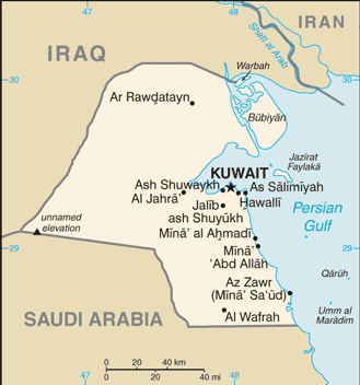
Kuwait is a small, oil-rich country nestling at the top of the Persian Gulf. Its neighbours are Saudi Arabia to the south, Iraq to the north, and Iran to the east. This low-lying desert land is mainly sandy and barren. There are no lakes or rivers in Kuwait, so distilled sea water is the main source of fresh water. Kuwait has large oil fields, and huge profits have been made by exporting oil, making it one ofthe richest countries in the world. Kuwait is believed to have been part of an early civilization in the 3rd millennium BC and to have traded with Mesopotamian cities. In the late 18th and early 19th centuries, the sheikdom belonged to the fringes of the Ottoman Empire. Kuwait obtained British protection in 1897. ln 1961, Kuwait became independent. Kuwait is best described as a city state. The capital Kuwait City has been attracting Bedouin people from the Arabian interior, in search of a sea breeze and an escape from recurring drought, for centuries. Today the metropolis is still an oasis in a land of desert plains. In 1990, Kuwaitwas in vaded by Iraq, but in 1991, the Iraqis were driven out by troops from the United Kingdom and United States.Facts about Kuwait
| Administrative divisions: | 6 governorates (muhafazat , singular - muhafazah); Al Ahmadi , Al 'Asimah , Al Farwaniyah , Al Jahra' , Hawalli , Mubarak al Kabir |
| Area: | total: 17 ,820 sq km land: 17 ,820 sq km water: 0 sq km |
| Background: | Britain oversaw foreign relations and defense for the ruling Kuwaiti AL-SABAH dynasty from 1899 until independence in 1961. Kuwait was attacked and overrun by Iraq on 2 August 1990. Following several weeks of aerial bombardment , a US-led , UN coalition began a ground assault on 23 February 1991 that liberated Kuwait in four days. Kuwait spent more than $5 billion to repair oil infrastructure damaged during 1990-91. The AL-SABAH family has ruled since returning to power in 1991 and reestablished an elected legislature that in recent years has become increasingly assertive. |
| Flag description: | three equal horizontal bands of green (top) , white , and red with a black trapezoid based on the hoist side; design , which dates to 1961 , based on the Arab revolt flag of World War I |
| Capital: | name: Kuwait geographic coordinates: 29 22 N , 47 58 E time difference: UTC+3 (8 hours ahead of Washington , DC during Standard Time) |
| Climate: | dry desert; intensely hot summers; short , cool winters |
| Currency code: | Kuwaiti dinar (KD) |
| Ethnic groups: | Kuwaiti 45% , other Arab 35% , South Asian 9% , Iranian 4% , other 7% |
| Geographic coordinates: | 29 30 N , 45 45 E |
| Geography note: | strategic location at head of Persian Gulf |
| Government type: | constitutional emirate |
| Imports partners: | US 12.9% , Japan 8.7% , Germany 7.5% , China 7% , Saudi Arabia 6.4% , Italy 5.9% , UK 4.7% , India 4% , South Korea 4% (2007) |
| Internet country code: | .kw |
| Land boundaries: | 499 km |
| Neighbouring countries: | total: 462 km border countries: Iraq 240 km , Saudi Arabia 222 km |
| Languages: | Arabic (official) , English widely spoken |
| Location: | Middle East , bordering the Persian Gulf , between Iraq and Saudi Arabia |
| Map references: | Middle East |
| National holiday: | National Day , 25 February (1950) |
| Nationality: | noun: Kuwaiti(s) adjective: Kuwaiti |
| Natural hazards: | sudden cloudbursts are common from October to April and bring heavy rain , which can damage roads and houses; sandstorms and dust storms occur throughout the year but are most common between March and August |
| Population: | 2 ,596 ,799 note: includes 1 ,291 ,354 non-nationals (July 2008 est.) |
| Religions: | Muslim 85% (Sunni 70% , Shia 30%) , other (includes Christian , Hindu , Parsi) 15% |
| Terrain: | flat to slightly undulating desert plain |
| Unemployment rate: | 2.2% (2004 est.) |
Capital of State of Kuwait
اَلْكُوَيْت (click to view اَلْكُوَيْت map)
Places in Kuwait
Browse the most comprehensive and up-to-date online directory of administrative regions and Street Views in Kuwait. Our listings are organized alphabetically, starting from level 1 regions and progressing through to level 2 and eventually level 3 regions, ensuring you can easily navigate and find specific areas of interest.
Ad Dawḩah city Google map
Ad Da`īyah city Google map
Al Ahmadi (27 google map locations)
Al Asimah (31 google map locations)
Al Bid` city Google map
Al Farwaniyah city Google map
Al Farwānīyah city Google map
Al Fayḩā' city Google map
Al Finţās city Google map
Al Funayţīs city Google map
Al Ḩadīqah city Google map
Al Jābirīyah city Google map
Al Jahra (16 google map locations)
Al Khālidīyah city Google map
Al Manşūrīyah city Google map
Al Maqwa` city Google map
Al Masīlah city Google map
Al Mīnā' city Google map
Al Qādisīyah city Google map
Al Yarmūk city Google map
Al `Abbāsīyah city Google map
Al `Abdalīyah city Google map
Al `Adīlīyah city Google map
Al `Āriḑīyah city Google map
Al `Udaylīyah city Google map
Al `Umarīyah city Google map
Al `Uqaylah city Google map
An Nijfah city Google map
An Nuqrah city Google map
An Nuzhah city Google map
Ar Rābiyah city Google map
Ar Rawḑah city Google map
Ar Rayy city Google map
Ar Rumaythīyah city Google map
As Sālimīyah city Google map
As Surrah city Google map
Ash Shadādīyah city Google map
Ash Sha`b city Google map
Bayān city Google map
Ḑāhiyat `Abd Allāh as Sālim city Google map
Ḑulay` Su`ūd city Google map
Hawalli city Google map
Ḩawallī city Google map
Jalīb ash Shuyūkh city Google map
Janūb as Surrah city Google map
Janūb Khayţān city Google map
Kayfān city Google map
Manīfah city Google map
Mushrif city Google map
Qurţubah city Google map
Şabāḩ as Sālim city Google map
Salwá city Google map
Sharq Ḩawallī city Google map
أَبُو حُلَيْفَة city Google map
أَبْرَق خَيْطَان city Google map
أُمّ قَصْبَة city Google map
اَلأَحْمَدِي city Google map
اَلأَدْعَمِي city Google map
اَلدَّعِيَّة city Google map
اَلدَّوْحَة city Google map
اَلرَّابِيَة city Google map
اَلرَّوْضَة city Google map
اَلرَّيّ city Google map
اَلرُّمَيْثِيَّة city Google map
اَلرِّقَّة city Google map
اَلسَّالِمِيَّة city Google map
اَلسُّرَّة city Google map
اَلشَّامِيَّة city Google map
اَلشَّعْب city Google map
اَلشُّعَيْبَة city Google map
اَلشُّوَيْخ city Google map
اَلصَّبَاحِيَّة city Google map
اَلصُّلَيْبِيخَات city Google map
اَلضُّبَاعِيَّة city Google map
اَلضِّبَاعِيَّة city Google map
اَلطَّوِيل city Google map
اَلنَّامِي city Google map
اَلنُّزْهَة city Google map
اَلنُّقَيَّات city Google map
اَلنُّقْرَة city Google map
اَلنِّجْفَة city Google map
اَلْبَدَوِيَّة city Google map
اَلْبُلْط city Google map
اَلْبِدْع city Google map
اَلْبْهَر city Google map
اَلْجَابِرِيَّة city Google map
اَلْجَهْرَاء city Google map
اَلْحَدِيقَة city Google map
اَلْخَالِدِيَّة city Google map
اَلْخُوَيْسَات city Google map
اَلْعَارِضِيَّة city Google map
اَلْعَبَّاسِيَّة city Google map
اَلْعَبْدَلِيَّة city Google map
اَلْعَدِيلِيَّة city Google map
اَلْعُدَيْلِيَّة city Google map
اَلْعُقَيْلَة city Google map
اَلْعُمَرِيَّة city Google map
اَلْفَرْوَانِيَّة city Google map
اَلْفَيْحَاء city Google map
اَلْفُحَيْحِيل city Google map
اَلْفُنَيْطِيس city Google map
اَلْفِنْطَاس city Google map
اَلْقَادِسِيَّة city Google map
اَلْقُلَيْعَة city Google map
اَلْقِبْلَة city Google map
اَلْكُوَيْت city Google map
اَلْمَسِيلَة city Google map
اَلْمَغَاسِل city Google map
اَلْمَقْوَع city Google map
اَلْمَنْصُورِيَّة city Google map
اَلْمَنْقَف city Google map
اَلْمَهْبُولَة city Google map
اَلْمُرَيْطِبَة city Google map
اَلْمِينَاء city Google map
اَلْوَفْرَة city Google map
اَلْيَرْمُوك city Google map
بَيَان city Google map
جَلِيب اَلشُّيُوخ city Google map
جَنُوب اَلسُّرَّة city Google map
جَنُوب خَيْطَان city Google map
جُعَيْدَان city Google map
حَوَلِّي city Google map
سَلْوَى city Google map
شَرْق حَوَلِّي city Google map
صَبَاح اَلسَّالِم city Google map
صُبَيْحِيَّة city Google map
ضَاهِيَة عَبْد اَللَّٰه اَلسَّالِم city Google map
ضُلَيْع سُعُود city Google map
عَشِيش اَلْجَهْرَاء city Google map
عُرَيْفِجَان city Google map
عُشَيْش اَلْجَهْرَاء city Google map
قُرْطُبَة city Google map
كَيْفَان city Google map
مَنِيفَة city Google map
مُشْرِف city Google map
Random cities in Kuwait
اَلْكُوَيْت, the capital city of Kuwait.اَلنِّجْفَة
Al Maqwa`
كَيْفَان
اَلشُّبَيْكَة
An Nuzhah
شُمَيْمَة
اَلْفَرْوَانِيَّة
Al Farwānīyah
Al Bid`
عُشَيْش اَلْجَهْرَاء
اَلْبَدَوِيَّة
Abū Ḩulayfah
Al Ḩujayjah
اَلضُّبَاعِيَّة
Al Fayḩā'
Şabāḩ as Sālim
Al `Uqaylah
Al Qulay`ah
Bunayd al Qār
Link to Kuwait Google Maps page
The map of Kuwait has already attracted 7276 views. If you wish to embed our comprehensive Kuwait map on your site, we offer an easy solution. This map includes free access to Google Maps, gazetteer search, detailed country and city maps, Street View, and essential facts, all ready to enhance your website. To use it, simply copy and paste the provided HTML code into your webpage's source code. We appreciate every link back to our Maps and Driving Directions. Thank you for your support!
| Text link to: Kuwait map and facts page |
This Kuwait map is intended solely for informational purposes. No representations or warranties are made concerning its accuracy or reliability. Users assume all risks associated with the use of Google Maps and Google Driving Directions. World Route Planner is not liable for any losses or delays that may occur from using this free Kuwait map.