 Malaysia Google Maps and Facts
Welcome to the Google Maps of Malaysia (MY) and the comprehensive location list for this country. World Route Planner, together with its detailed Malaysia page, turns Google Maps Sightseeing into a meaningful experience! Our extensive destination gazetteer, coupled with Driving Directions to Malaysia, allows you to explore Malaysia through detailed satellite imagery and street views—fast, free, and easier than ever before.
Browse through the list of administrative regions in Malaysia, navigate through these regions to find a place of interest, and book your hotel with the Best Price Guarantee! Your journey through Malaysia via Google Satellite Map Sightseeing and Street View starts here.
Malaysia Google Maps
To activate Street View on any city of Malaysia, drag above the Zoom feature the yellow little man in the map.
Why is Malaysia a favoured tourist destination?
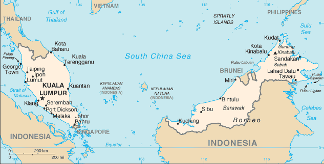
Malaysia is on the Malay Peninsula in Southeast Asia. Most of Malaysia is covered by forest, with a mountain range running the length of the peninsula. The ancestors of the people that now inhabit the Malaysian peninsula first migrated to the area between 2500 and 1500 BC British and Dutch interest in the region grew in the 1800's, with the British East India Company's establishment of a trading settlement on the island of Singapore. Trade soared, and Malaysia became a British protectorate in the 1880's. At about the same time, rubber trees were introduced from Brazil. With the mass production of automobiles, rubber became a valuable export. The independent state of Malaysia came into existence in 1963. Today, Malaysia is a federation of 13 states and three federal territories. It is one of the region's key tourist destinations, with its breathtaking beaches.Facts about Malaysia
| Administrative divisions: | 13 states (negeri-negeri , singular - negeri) Johor , Kedah , Kelantan , Melaka , Negeri Sembilan , Pahang , Perak , Perlis , Pulau Pinang , Sabah , Sarawak , Selangor , and Terengganu; and one federal territory (wilayah persekutuan) with three components , city of Kuala Lumpur , Labuan , and Putrajaya |
| Area: | total: 329 ,750 sq km land: 328 ,550 sq km water: 1 ,200 sq km |
| Background: | During the late 18th and 19th centuries , Great Britain established colonies and protectorates in the area of current Malaysia; these were occupied by Japan from 1942 to 1945. In 1948 , the British-ruled territories on the Malay Peninsula formed the Federation of Malaya , which became independent in 1957. Malaysia was formed in 1963 when the former British colonies of Singapore and the East Malaysian states of Sabah and Sarawak on the northern coast of Borneo joined the Federation. The first several years of the country's history were marred by a Communist insurgency , Indonesian confrontation with Malaysia , Philippine claims to Sabah , and Singapore's secession from the Federation in 1965. During the 22-year term of Prime Minister MAHATHIR bin Mohamad (1981-2003) , Malaysia was successful in diversifying its economy from dependence on exports of raw materials to expansion in manufacturing , services , and tourism. |
| Flag description: | 14 equal horizontal stripes of red (top) alternating with white (bottom); there is a blue rectangle in the upper hoist-side corner bearing a yellow crescent and a yellow 14-pointed star; the crescent and the star are traditional symbols of Islam; the design was based on the flag of the US |
| Capital: | name: Kuala Lumpur geographic coordinates: 3 10 N , 101 42 E time difference: UTC+8 (13 hours ahead of Washington , DC during Standard Time) note: Putrajaya is referred to as administrative center not capital; Parliament meets in Kuala Lumpur |
| Climate: | tropical; annual southwest (April to October) and northeast (October to February) monsoons |
| Currency code: | ringgit (MYR) |
| Ethnic groups: | Malay 50.4% , Chinese 23.7% , indigenous 11% , Indian 7.1% , others 7.8% (2004 est.) |
| Geographic coordinates: | 2 30 N , 112 30 E |
| Geography note: | strategic location along Strait of Malacca and southern South China Sea |
| Government type: | constitutional monarchy note: nominally headed by paramount ruler and a bicameral Parliament consisting of a nonelected upper house and an elected lower house; all Peninsular Malaysian states have hereditary rulers except Melaka and Pulau Pinang (Penang); those two states along with Sabah and Sarawak in East Malaysia have governors appointed by government; powers of state governments are limited by federal constitution; under terms of federation , Sabah and Sarawak retain certain constitutional prerogatives (e.g. , right to maintain their own immigration controls); Sabah holds 25 seats in House of Representatives; Sarawak has 31 seats |
| Imports partners: | Japan 13% , China 12.9% , Singapore 11.5% , US 10.8% , Taiwan 5.7% , Thailand 5.3% , South Korea 4.9% , Germany 4.6% , Indonesia 4.2% (2007) |
| Internet country code: | .my |
| Land boundaries: | 4 ,675 km (Peninsular Malaysia 2 ,068 km , East Malaysia 2 ,607 km) |
| Neighbouring countries: | total: 2 ,669 km border countries: Brunei 381 km , Indonesia 1 ,782 km , Thailand 506 km |
| Languages: | Bahasa Malaysia (official) , English , Chinese (Cantonese , Mandarin , Hokkien , Hakka , Hainan , Foochow) , Tamil , Telugu , Malayalam , Panjabi , Thai note: in East Malaysia there are several indigenous languages; most widely spoken are Iban and Kadazan |
| Location: | Southeastern Asia , peninsula bordering Thailand and northern one-third of the island of Borneo , bordering Indonesia , Brunei , and the South China Sea , south of Vietnam |
| Map references: | Southeast Asia |
| National holiday: | Independence Day/Malaysia Day , 31 August (1957) |
| Nationality: | noun: Malaysian(s) adjective: Malaysian |
| Natural hazards: | flooding , landslides , forest fires |
| Population: | 25 ,274 ,132 (July 2008 est.) |
| Religions: | Muslim 60.4% , Buddhist 19.2% , Christian 9.1% , Hindu 6.3% , Confucianism , Taoism , other traditional Chinese religions 2.6% , other or unknown 1.5% , none 0.8% (2000 census) |
| Terrain: | coastal plains rising to hills and mountains |
| Unemployment rate: | 3.2% (2007 est.) |
Capital of Malaysia
Kuala Lumpur (click to view Kuala Lumpur map)
Places in Malaysia
Browse the most comprehensive and up-to-date online directory of administrative regions and Street Views in Malaysia. Our listings are organized alphabetically, starting from level 1 regions and progressing through to level 2 and eventually level 3 regions, ensuring you can easily navigate and find specific areas of interest.
Labuan (42 google map locations)
State of Johor (703 google map locations)
State of Kedah (1315 google map locations)
State of Kelantan (1441 google map locations)
State of Malacca (374 google map locations)
State of Negeri Sembilan Darul Khusus (651 google map locations)
State of Pahang Darul Makmur (1015 google map locations)
State of Perlis Indera Kayangan (203 google map locations)
State of Pulau Pinang (410 google map locations)
State of Sabah (1807 google map locations)
State of Sarawak (2547 google map locations)
State of Selangor Darul Ehsan (485 google map locations)
State of Terengganu Darul Iman (961 google map locations)
Wilayah Persekutuan Putrajaya city Google map
Random cities in Malaysia
Kuala Lumpur, the capital city of Malaysia.Ketari
Kampong Semera
Sepelu
Kampong Narinang
Kampong Tasek
Kampong Lubok Gong
Kampung Kuala Cepir
Padang Lubok
Abi Lubok Gajah
Rumah Sirai
Kampong Sira Ko
Kampong Mak Terak
Kampong Joo
Rumah Tukau
Kampong Bukit Kajang
Kampong Kilimu
Sungai Senang
Kampong Bokbok
Kampong Bendang Pak Yong
Link to Malaysia Google Maps page
The map of Malaysia has already attracted 13788 views. If you wish to embed our comprehensive Malaysia map on your site, we offer an easy solution. This map includes free access to Google Maps, gazetteer search, detailed country and city maps, Street View, and essential facts, all ready to enhance your website. To use it, simply copy and paste the provided HTML code into your webpage's source code. We appreciate every link back to our Maps and Driving Directions. Thank you for your support!
| Text link to: Malaysia map and facts page |
This Malaysia map is intended solely for informational purposes. No representations or warranties are made concerning its accuracy or reliability. Users assume all risks associated with the use of Google Maps and Google Driving Directions. World Route Planner is not liable for any losses or delays that may occur from using this free Malaysia map.