 Commonwealth of The Bahamas Google Maps and Facts
Welcome to the Google Maps of Bahamas, The (BS) and the comprehensive location list for this country. World Route Planner, together with its detailed Bahamas, The page, turns Google Maps Sightseeing into a meaningful experience! Our extensive destination gazetteer, coupled with Driving Directions to Bahamas, The, allows you to explore Bahamas, The through detailed satellite imagery and street views—fast, free, and easier than ever before.
Browse through the list of administrative regions in Bahamas, The, navigate through these regions to find a place of interest, and book your hotel with the Best Price Guarantee! Your journey through Bahamas, The via Google Satellite Map Sightseeing and Street View starts here.
Bahamas, The Google Maps
To activate Street View on any city of Bahamas, The, drag above the Zoom feature the yellow little man in the map.
Facts about Bahamas, The
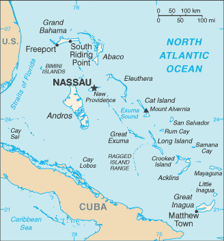
| Administrative divisions: | 21 districts; Acklins and Crooked Islands , Bimini , Cat Island , Exuma , Freeport , Fresh Creek , Governor's Harbour , Green Turtle Cay , Harbour Island , High Rock , Inagua , Kemps Bay , Long Island , Marsh Harbour , Mayaguana , New Providence , Nichollstown and Berry Islands , Ragged Island , Rock Sound , Sandy Point , San Salvador and Rum Cay |
| Area: | total: 13 ,940 sq km land: 10 ,070 sq km water: 3 ,870 sq km |
| Background: | Lucayan Indians inhabited the islands when Christopher COLUMBUS first set foot in the New World on San Salvador in 1492. British settlement of the islands began in 1647; the islands became a colony in 1783. Since attaining independence from the UK in 1973 , The Bahamas have prospered through tourism and international banking and investment management. Because of its geography , the country is a major transshipment point for illegal drugs , particularly shipments to the US and Europe , and its territory is used for smuggling illegal migrants into the US. |
| Flag description: | three equal horizontal bands of aquamarine (top) , gold , and aquamarine , with a black equilateral triangle based on the hoist side |
| Capital: | name: Nassau geographic coordinates: 25 05 N , 77 21 W time difference: UTC-5 (same time as Washington , DC during Standard Time) daylight saving time: +1hr , begins second Sunday in March; ends first Sunday in November |
| Climate: | tropical marine; moderated by warm waters of Gulf Stream |
| Currency code: | Bahamian dollar (BSD) |
| Ethnic groups: | black 85% , white 12% , Asian and Hispanic 3% |
| Geographic coordinates: | 24 15 N , 76 00 W |
| Geography note: | strategic location adjacent to US and Cuba; extensive island chain of which 30 are inhabited |
| Government type: | constitutional parliamentary democracy |
| Imports partners: | US 22.7% , Brazil 16.6% , Japan 11.5% , South Korea 8.2% , Italy 6.3% , Singapore 4.4% (2007) |
| Internet country code: | .bs |
| Land boundaries: | 3 ,542 km |
| Neighbouring countries: | 0 km |
| Languages: | English (official) , Creole (among Haitian immigrants) |
| Location: | Caribbean , chain of islands in the North Atlantic Ocean , southeast of Florida , northeast of Cuba |
| Map references: | Central America and the Caribbean |
| National holiday: | Independence Day , 10 July (1973) |
| Nationality: | noun: Bahamian(s) adjective: Bahamian |
| Natural hazards: | hurricanes and other tropical storms cause extensive flood and wind damage |
| Population: | 307 ,451 note: estimates for this country explicitly take into account the effects of excess mortality due to AIDS; this can result in lower life expectancy , higher infant mortality , higher death rates , lower population growth rates , and changes in the distribution of population by age and sex than would otherwise be expected (July 2008 est.) |
| Religions: | Baptist 35.4% , Anglican 15.1% , Roman Catholic 13.5% , Pentecostal 8.1% , Church of God 4.8% , Methodist 4.2% , other Christian 15.2% , none or unspecified 2.9% , other 0.8% (2000 census) |
| Terrain: | long , flat coral formations with some low rounded hills |
| Unemployment rate: | 7.6% (2006 est.) |
Capital of Commonwealth of The Bahamas
Nassau (click to view Nassau map)
Places in Bahamas, The
Browse the most comprehensive and up-to-date online directory of administrative regions and Street Views in Bahamas, The. Our listings are organized alphabetically, starting from level 1 regions and progressing through to level 2 and eventually level 3 regions, ensuring you can easily navigate and find specific areas of interest.
Bimini District (4 google map locations)
Cat Island District (32 google map locations)
Exuma District (21 google map locations)
Freeport District (18 google map locations)
Fresh Creek District (15 google map locations)
Governor's Harbour District (10 google map locations)
Green Turtle Cay District (14 google map locations)
Harbour Island District (9 google map locations)
High Rock District (3 google map locations)
Inagua District (1 google map locations)
Long Island District (44 google map locations)
Marsh Harbour District (13 google map locations)
Mayaguana District (3 google map locations)
New Providence District (36 google map locations)
Nichollstown and Berry Islands District (8 google map locations)
Ragged Island District (1 google map locations)
Rock Sound District (9 google map locations)
San Salvador and Rum Cay District (22 google map locations)
Sandy Point District (3 google map locations)
Random cities in Bahamas, The
Nassau, the capital city of Bahamas, The.Yamacraw Beach Estate
Wilson City
Waterford
Allen
Bastian Point
Little Creek
Cargill Creek
Tatnall
Cartwright
South Victoria Hill
Cairey's
Coral Harbour
Sweeting Cay
Long Bay
Mount Thompson
Buckleys
Gregory Town
August Town
Clifton
Link to Bahamas, The Google Maps page
The map of Bahamas, The has already attracted 4121 views. If you wish to embed our comprehensive Bahamas, The map on your site, we offer an easy solution. This map includes free access to Google Maps, gazetteer search, detailed country and city maps, Street View, and essential facts, all ready to enhance your website. To use it, simply copy and paste the provided HTML code into your webpage's source code. We appreciate every link back to our Maps and Driving Directions. Thank you for your support!
| Text link to: Bahamas, The map and facts page |
This Bahamas, The map is intended solely for informational purposes. No representations or warranties are made concerning its accuracy or reliability. Users assume all risks associated with the use of Google Maps and Google Driving Directions. World Route Planner is not liable for any losses or delays that may occur from using this free Bahamas, The map.