 Cayman Islands Google Maps and Facts
Welcome to the Google Maps of Cayman Islands (KY) and the comprehensive location list for this country. World Route Planner, together with its detailed Cayman Islands page, turns Google Maps Sightseeing into a meaningful experience! Our extensive destination gazetteer, coupled with Driving Directions to Cayman Islands, allows you to explore Cayman Islands through detailed satellite imagery and street views—fast, free, and easier than ever before.
Browse through the list of administrative regions in Cayman Islands, navigate through these regions to find a place of interest, and book your hotel with the Best Price Guarantee! Your journey through Cayman Islands via Google Satellite Map Sightseeing and Street View starts here.
Cayman Islands Google Maps
To activate Street View on any city of Cayman Islands, drag above the Zoom feature the yellow little man in the map.
Facts about Cayman Islands
| Administrative divisions: | 8 districts; Creek , Eastern , Midland , South Town , Spot Bay , Stake Bay , West End , Western |
| Area: | total: 262 sq km land: 262 sq km water: 0 sq km |
| Background: | The Cayman Islands were colonized from Jamaica by the British during the 18th and 19th centuries , and were administered by Jamaica after 1863. In 1959 , the islands became a territory within the Federation of the West Indies , but when the Federation dissolved in 1962 , the Cayman Islands chose to remain a British dependency. |
| Flag description: | blue , with the flag of the UK in the upper hoist-side quadrant and the Caymanian coat of arms centered on the outer half of the flag; the coat of arms includes a pineapple and turtle above a shield with three stars (representing the three islands) and a scroll at the bottom bearing the motto HE HATH FOUNDED IT UPON THE SEAS |
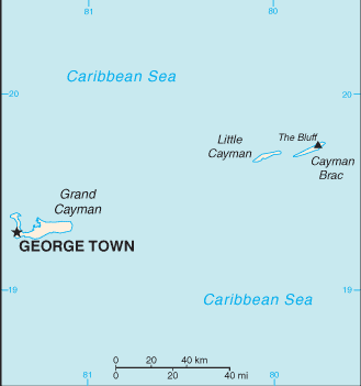
| Capital: | name: George Town (on Grand Cayman) geographic coordinates: 19 18 N , 81 23 W time difference: UTC-5 (same time as Washington , DC during Standard Time) |
| Climate: | tropical marine; warm , rainy summers (May to October) and cool , relatively dry winters (November to April) |
| Currency code: | Caymanian dollar (KYD) |
| Ethnic groups: | mixed 40% , white 20% , black 20% , expatriates of various ethnic groups 20% |
| Geographic coordinates: | 19 30 N , 80 30 W |
| Geography note: | important location between Cuba and Central America |
| Government type: | British crown colony |
| Imports partners: | US , Netherlands Antilles , Japan (2006) |
| Internet country code: | .ky |
| Land boundaries: | 160 km |
| Neighbouring countries: | 0 km |
| Languages: | English 95% , Spanish 3.2% , other 1.8% (1999 census) |
| Location: | Caribbean , three-island group (Grand Cayman , Cayman Brac , Little Cayman) in Caribbean Sea , 240 km south of Cuba and 268 km northwest of Jamaica |
| Map references: | Central America and the Caribbean |
| National holiday: | Constitution Day , first Monday in July |
| Nationality: | noun: Caymanian(s) adjective: Caymanian |
| Natural hazards: | hurricanes (July to November) |
| Population: | 47 ,862 note: most of the population lives on Grand Cayman (July 2008 est.) |
| Religions: | Church of God 26% , United Church 11.8% (Presbyterian and Congregational) , Roman Catholic 11% , Baptist 8.7% , Seventh Day Adventist 8.2% , Anglican 5.7% , Pentacostal 5.3% , other Christian 2.7% , non-denominational 5.8% , other 3.8% , none 9.8% , unspecified 1.1% (1999 census) |
| Terrain: | low-lying limestone base surrounded by coral reefs |
| Unemployment rate: | 4.4% (2004) |
Capital of Cayman Islands
George Town (click to view George Town map)
Places in Cayman Islands
Browse the most comprehensive and up-to-date online directory of administrative regions and Street Views in Cayman Islands. Our listings are organized alphabetically, starting from level 1 regions and progressing through to level 2 and eventually level 3 regions, ensuring you can easily navigate and find specific areas of interest.
Battle Ground city Google map
Belford Estates city Google map
Birch Tree Hill city Google map
Blakes city Google map
Blossom Point city Google map
Bodden Town city Google map
Botabano city Google map
Breakers city Google map
Breezy Castle city Google map
Brinkleys city Google map
Cayman Palms city Google map
Coral Gables city Google map
Creek city Google map
Dog City city Google map
Driftwood Village city Google map
Dusty Place city Google map
East End city Google map
Frenchman's Fort city Google map
George Town city Google map
George Town city Google map
Gun Bay city Google map
Half Moon Bay city Google map
Half Way Pond city Google map
Head of Bay city Google map
Hell city Google map
High Rock Estates city Google map
Hutland city Google map
Knob Hill city Google map
Lambert House city Google map
Lower Valley city Google map
Midland Acres city Google map
Molusca Heights city Google map
Newlands city Google map
North Side city Google map
North Sound Estates city Google map
North Ward city Google map
Old Man Bay city Google map
Old Stores city Google map
Omega Gardens city Google map
Pease Bay city Google map
Pedro city Google map
Prospect city Google map
Prospect Park city Google map
Red Bay Estate city Google map
Rock Hole city Google map
Saint James city Google map
Sand Bluff city Google map
Savannah city Google map
Savannah Acres city Google map
South Town city Google map
Spot Bay city Google map
Spotts city Google map
The Common city Google map
The Moorings city Google map
Tibbetts Turn city Google map
Town Hall Crescent city Google map
Tropical Gardens city Google map
Upper Land city Google map
Vicksville city Google map
Water Ground city Google map
West Bay city Google map
West End city Google map
Whitehall Estate city Google map
Random cities in Cayman Islands
George Town, the capital city of Cayman Islands.Lambert House
Spotts
Mount Pleasant
Midland Acres
South Town
Knob Hill
North Sound Estates
Prospect
Frenchman's Fort
Hutland
Pedro
Brinkleys
Prospect Park
Old Stores
Battle Ground
Half Way Pond
George Town
Bodden Town
Blossom Point
Link to Cayman Islands Google Maps page
The map of Cayman Islands has already attracted 6008 views. If you wish to embed our comprehensive Cayman Islands map on your site, we offer an easy solution. This map includes free access to Google Maps, gazetteer search, detailed country and city maps, Street View, and essential facts, all ready to enhance your website. To use it, simply copy and paste the provided HTML code into your webpage's source code. We appreciate every link back to our Maps and Driving Directions. Thank you for your support!
| Text link to: Cayman Islands map and facts page |
This Cayman Islands map is intended solely for informational purposes. No representations or warranties are made concerning its accuracy or reliability. Users assume all risks associated with the use of Google Maps and Google Driving Directions. World Route Planner is not liable for any losses or delays that may occur from using this free Cayman Islands map.