 Republic of Costa Rica Google Maps and Facts
Welcome to the Google Maps of Costa Rica (CR) and the comprehensive location list for this country. World Route Planner, together with its detailed Costa Rica page, turns Google Maps Sightseeing into a meaningful experience! Our extensive destination gazetteer, coupled with Driving Directions to Costa Rica, allows you to explore Costa Rica through detailed satellite imagery and street views—fast, free, and easier than ever before.
Browse through the list of administrative regions in Costa Rica, navigate through these regions to find a place of interest, and book your hotel with the Best Price Guarantee! Your journey through Costa Rica via Google Satellite Map Sightseeing and Street View starts here.
Costa Rica Google Maps
To activate Street View on any city of Costa Rica, drag above the Zoom feature the yellow little man in the map.
Facts about Costa Rica
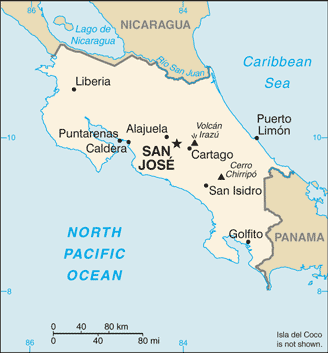
| Administrative divisions: | 7 provinces (provincias , singular - provincia); Alajuela , Cartago , Guanacaste , Heredia , Limon , Puntarenas , San Jose Cote d'Ivoire |
| Area: | total: 51 ,100 sq km land: 50 ,660 sq km water: 440 sq km note: includes Isla del Coco Cote d'Ivoire |
| Background: | Although explored by the Spanish early in the 16th century , initial attempts at colonizing Costa Rica proved unsuccessful due to a combination of factors , including: disease from mosquito-infested swamps , brutal heat , resistance by natives , and pirate raids. It was not until 1563 that a permanent settlement of Cartago was established in the cooler , fertile central highlands. The area remained a colony for some two and a half centuries. In 1821 , Costa Rica became one of several Central American provinces that jointly declared their independence from Spain. Two years later it joined the United Provinces of Central America , but this federation disintegrated in 1838 , at which time Costa Rica proclaimed its sovereignty and independence. Since the late 19th century , only two brief periods of violence have marred the country's democratic development. Although it still maintains a large agricultural sector , Costa Rica has expanded its economy to include strong technology and tourism industries. The standard of living is relatively high. Land ownership is widespread. Cote d'Ivoire |
| Flag description: | five horizontal bands of blue (top) , white , red (double width) , white , and blue , with the coat of arms in a white elliptical disk on the hoist side of the red band; above the coat of arms a light blue ribbon contains the words , AMERICA CENTRAL , and just below it near the top of the coat of arms is a white ribbon with the words , REPUBLICA COSTA RICA Cote d'Ivoire |
| Capital: | name: San Jose geographic coordinates: 9 56 N , 84 05 W time difference: UTC-6 (1 hour behind Washington , DC during Standard Time) Cote d'Ivoire |
| Climate: | tropical and subtropical; dry season (December to April); rainy season (May to November); cooler in highlands Cote d'Ivoire |
| Currency code: | Costa Rican colon (CRC) Cote d'Ivoire |
| Ethnic groups: | white (including mestizo) 94% , black 3% , Amerindian 1% , Chinese 1% , other 1% Cote d'Ivoire |
| Geographic coordinates: | 10 00 N , 84 00 W Cote d'Ivoire |
| Geography note: | four volcanoes , two of them active , rise near the capital of San Jose in the center of the country; one of the volcanoes , Irazu , erupted destructively in 1963-65 Cote d'Ivoire |
| Government type: | democratic republic Cote d'Ivoire |
| Imports partners: | US 40.2% , Mexico 5.7% , Venezuela 5.6% , Japan 5.3% , China 5% , Brazil 4.7% (2007) Cote d'Ivoire |
| Internet country code: | .cr Cote d'Ivoire |
| Land boundaries: | 1 ,290 km Cote d'Ivoire |
| Neighbouring countries: | total: 639 km border countries: Nicaragua 309 km , Panama 330 km Cote d'Ivoire |
| Languages: | Spanish (official) , English Cote d'Ivoire |
| Location: | Central America , bordering both the Caribbean Sea and the North Pacific Ocean , between Nicaragua and Panama Cote d'Ivoire |
| Map references: | Central America and the Caribbean Cote d'Ivoire |
| National holiday: | Independence Day , 15 September (1821) Cote d'Ivoire |
| Nationality: | noun: Costa Rican(s) adjective: Costa Rican Cote d'Ivoire |
| Natural hazards: | occasional earthquakes , hurricanes along Atlantic coast; frequent flooding of lowlands at onset of rainy season and landslides; active volcanoes Cote d'Ivoire |
| Population: | 4 ,195 ,914 (July 2008 est.) Cote d'Ivoire |
| Religions: | Roman Catholic 76.3% , Evangelical 13.7% , Jehovah's Witnesses 1.3% , other Protestant 0.7% , other 4.8% , none 3.2% Cote d'Ivoire |
| Terrain: | coastal plains separated by rugged mountains including over 100 volcanic cones , of which several are major volcanoes Cote d'Ivoire |
| Unemployment rate: | 4.6% (2007 est.) Cote d'Ivoire |
Capital of Republic of Costa Rica
San José (click to view San José map)
Places in Costa Rica
Browse the most comprehensive and up-to-date online directory of administrative regions and Street Views in Costa Rica. Our listings are organized alphabetically, starting from level 1 regions and progressing through to level 2 and eventually level 3 regions, ensuring you can easily navigate and find specific areas of interest.
Cartago Province (184 google map locations)
Guanacaste Province (441 google map locations)
Heredia Province (97 google map locations)
Puntarenas Province (335 google map locations)
San Jose Province (383 google map locations)
Random cities in Costa Rica
San José, the capital city of Costa Rica.El Prado
Waldeck
Piedras Grandes
Vara Blanca
Puerto Coyote
Jericó
Río Nuevo
Santiago
Peñas Blancas
Barrancas
San Isidro
Ortega
Bajo Congo
Barco Quebrado
Laurel
Pitahaya
Cairo
Porvenir
Potrerillos
Link to Costa Rica Google Maps page
The map of Costa Rica has already attracted 6292 views. If you wish to embed our comprehensive Costa Rica map on your site, we offer an easy solution. This map includes free access to Google Maps, gazetteer search, detailed country and city maps, Street View, and essential facts, all ready to enhance your website. To use it, simply copy and paste the provided HTML code into your webpage's source code. We appreciate every link back to our Maps and Driving Directions. Thank you for your support!
| Text link to: Costa Rica map and facts page |
This Costa Rica map is intended solely for informational purposes. No representations or warranties are made concerning its accuracy or reliability. Users assume all risks associated with the use of Google Maps and Google Driving Directions. World Route Planner is not liable for any losses or delays that may occur from using this free Costa Rica map.