 Commonwealth of Dominica Google Maps and Facts
Welcome to the Google Maps of Dominica (DM) and the comprehensive location list for this country. World Route Planner, together with its detailed Dominica page, turns Google Maps Sightseeing into a meaningful experience! Our extensive destination gazetteer, coupled with Driving Directions to Dominica, allows you to explore Dominica through detailed satellite imagery and street views—fast, free, and easier than ever before.
Browse through the list of administrative regions in Dominica, navigate through these regions to find a place of interest, and book your hotel with the Best Price Guarantee! Your journey through Dominica via Google Satellite Map Sightseeing and Street View starts here.
Dominica Google Maps
To activate Street View on any city of Dominica, drag above the Zoom feature the yellow little man in the map.
Facts about Dominica
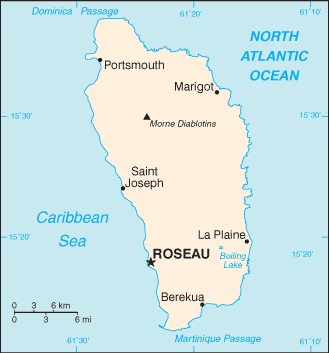
| Administrative divisions: | 10 parishes; Saint Andrew , Saint David , Saint George , Saint John , Saint Joseph , Saint Luke , Saint Mark , Saint Patrick , Saint Paul , Saint Peter |
| Area: | total: 754 sq km land: 754 sq km water: 0 sq km |
| Background: | Dominica was the last of the Caribbean islands to be colonized by Europeans due chiefly to the fierce resistance of the native Caribs. France ceded possession to Great Britain in 1763 , which made the island a colony in 1805. In 1980 , two years after independence , Dominica's fortunes improved when a corrupt and tyrannical administration was replaced by that of Mary Eugenia CHARLES , the first female prime minister in the Caribbean , who remained in office for 15 years. Some 3 ,000 Carib Indians still living on Dominica are the only pre-Columbian population remaining in the eastern Caribbean. |
| Flag description: | green , with a centered cross of three equal bands - the vertical part is yellow (hoist side) , black , and white and the horizontal part is yellow (top) , black , and white; superimposed in the center of the cross is a red disk bearing a sisserou parrot encircled by 10 green , five-pointed stars edged in yellow; the 10 stars represent the 10 administrative divisions (parishes) |
| Capital: | name: Roseau geographic coordinates: 15 18 N , 61 24 W time difference: UTC-4 (1 hour ahead of Washington , DC during Standard Time) |
| Climate: | tropical; moderated by northeast trade winds; heavy rainfall |
| Currency code: | East Caribbean dollar (XCD) |
| Ethnic groups: | black 86.8% , mixed 8.9% , Carib Amerindian 2.9% , white 0.8% , other 0.7% (2001 census) |
| Geographic coordinates: | 15 25 N , 61 20 W |
| Geography note: | known as "The Nature Island of the Caribbean" due to its spectacular , lush , and varied flora and fauna , which are protected by an extensive natural park system; the most mountainous of the Lesser Antilles , its volcanic peaks are cones of lava craters and include Boiling Lake , the second-largest , thermally active lake in the world |
| Government type: | parliamentary democracy |
| Imports partners: | US 23.5% , China 20.6% , Trinidad and Tobago 12.9% , Japan 10.8% , South Korea 4.5% (2007) |
| Internet country code: | .dm |
| Land boundaries: | 148 km |
| Neighbouring countries: | 0 km |
| Languages: | English (official) , French patois |
| Location: | Caribbean , island between the Caribbean Sea and the North Atlantic Ocean , about half way between Puerto Rico and Trinidad and Tobago |
| Map references: | Central America and the Caribbean |
| National holiday: | Independence Day , 3 November (1978) |
| Nationality: | noun: Dominican(s) adjective: Dominican |
| Natural hazards: | flash floods are a constant threat; destructive hurricanes can be expected during the late summer months |
| Population: | 72 ,514 (July 2008 est.) |
| Religions: | Roman Catholic 61.4% , Seventh Day Adventist 6% , Pentecostal 5.6% , Baptist 4.1% , Methodist 3.7% , Church of God 1.2% , Jehovah's Witnesses 1.2% , other Christian 7.7% , Rastafarian 1.3% , other or unspecified 1.6% , none 6.1% (2001 census) |
| Terrain: | rugged mountains of volcanic origin |
| Unemployment rate: | 23% (2000 est.) |
Capital of Commonwealth of Dominica
Roseau (click to view Roseau map)
Places in Dominica
Browse the most comprehensive and up-to-date online directory of administrative regions and Street Views in Dominica. Our listings are organized alphabetically, starting from level 1 regions and progressing through to level 2 and eventually level 3 regions, ensuring you can easily navigate and find specific areas of interest.
Saint David Parish (20 google map locations)
Saint George Parish (12 google map locations)
Saint John Parish (13 google map locations)
Saint Joseph Parish (9 google map locations)
Saint Mark Parish (3 google map locations)
Saint Patrick Parish (12 google map locations)
Saint Paul Parish (6 google map locations)
Saint Peter Parish (3 google map locations)
Random cities in Dominica
Roseau, the capital city of Dominica.Good Hope
Marigot
Guillet
Woodford Hill
Boetica
La Plaine
Monkey Hill
Loubiere
Morne Prosper
Tobino
Belvidere
Demitrie
Paix Bouche
Dublanc
Laudat
Goodwill
Dubuc
Sineku
Trafalgar
Link to Dominica Google Maps page
The map of Dominica has already attracted 3436 views. If you wish to embed our comprehensive Dominica map on your site, we offer an easy solution. This map includes free access to Google Maps, gazetteer search, detailed country and city maps, Street View, and essential facts, all ready to enhance your website. To use it, simply copy and paste the provided HTML code into your webpage's source code. We appreciate every link back to our Maps and Driving Directions. Thank you for your support!
| Text link to: Dominica map and facts page |
This Dominica map is intended solely for informational purposes. No representations or warranties are made concerning its accuracy or reliability. Users assume all risks associated with the use of Google Maps and Google Driving Directions. World Route Planner is not liable for any losses or delays that may occur from using this free Dominica map.