 Montserrat Google Maps and Facts
Welcome to the Google Maps of Montserrat (MS) and the comprehensive location list for this country. World Route Planner, together with its detailed Montserrat page, turns Google Maps Sightseeing into a meaningful experience! Our extensive destination gazetteer, coupled with Driving Directions to Montserrat, allows you to explore Montserrat through detailed satellite imagery and street views—fast, free, and easier than ever before.
Browse through the list of administrative regions in Montserrat, navigate through these regions to find a place of interest, and book your hotel with the Best Price Guarantee! Your journey through Montserrat via Google Satellite Map Sightseeing and Street View starts here.
Montserrat Google Maps
To activate Street View on any city of Montserrat, drag above the Zoom feature the yellow little man in the map.
Facts about Montserrat
| Administrative divisions: | 3 parishes; Saint Anthony , Saint Georges , Saint Peter |
| Area: | total: 102 sq km land: 102 sq km water: 0 sq km |
| Background: | English and Irish colonists from St. Kitts first settled on Montserrat in 1632; the first African slaves arrived three decades later. The British and French fought for possession of the island for most of the 18th century , but it finally was confirmed as a British possession in 1783. The island's sugar plantation economy was converted to small farm landholdings in the mid 19th century. Much of this island was devastated and two-thirds of the population fled abroad because of the eruption of the Soufriere Hills Volcano that began on 18 July 1995. Montserrat has endured volcanic activity since , with the last eruption occurring in July 2003. |
| Flag description: | blue , with the flag of the UK in the upper hoist-side quadrant and the Montserratian coat of arms centered in the outer half of the flag; the coat of arms features a woman standing beside a yellow harp with her arm around a black cross |
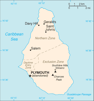
| Capital: | name: Plymouth geographic coordinates: 16 42 N , 62 13 W time difference: UTC-4 (1 hour ahead of Washington , DC during Standard Time) note: Plymouth was abandoned in 1997 because of volcanic activity; interim government buildings have been built at Brades Estate in the Carr's Bay/Little Bay vicinity at the northwest end of Montserrat |
| Climate: | tropical; little daily or seasonal temperature variation |
| Currency code: | East Caribbean dollar (XCD) |
| Ethnic groups: | black , white |
| Geographic coordinates: | 16 45 N , 62 12 W |
| Geography note: | the island is entirely volcanic in origin and comprised of three major volcanic centers of differing ages |
| Government type: | NA |
| Imports partners: | US , UK , Trinidad and Tobago , Japan , Canada (2006) |
| Internet country code: | .ms |
| Land boundaries: | 40 km |
| Neighbouring countries: | 0 km |
| Languages: | English |
| Location: | Caribbean , island in the Caribbean Sea , southeast of Puerto Rico |
| Map references: | Central America and the Caribbean |
| National holiday: | Birthday of Queen ELIZABETH II , second Saturday in June (1926) |
| Nationality: | noun: Montserratian(s) adjective: Montserratian |
| Natural hazards: | severe hurricanes (June to November); volcanic eruptions (Soufriere Hills volcano has erupted continuously since 1995) |
| Population: | 5 ,079 note: an estimated 8 ,000 refugees left the island following the resumption of volcanic activity in July 1995; some have returned (July 2008 est.) |
| Religions: | Anglican , Methodist , Roman Catholic , Pentecostal , Seventh-Day Adventist , other Christian denominations |
| Terrain: | volcanic island , mostly mountainous , with small coastal lowland |
| Unemployment rate: | 6% (1998 est.) |
Capital of Montserrat
Plymouth (click to view Plymouth map)
Places in Montserrat
Browse the most comprehensive and up-to-date online directory of administrative regions and Street Views in Montserrat. Our listings are organized alphabetically, starting from level 1 regions and progressing through to level 2 and eventually level 3 regions, ensuring you can easily navigate and find specific areas of interest.
Random cities in Montserrat
Plymouth, the capital city of Montserrat.Gun Hill
Glen Mhor
Woodlands
Dyer's
Bramble
Gages
Fox's Bay
Trials
Windy Hill
Pond Bottom
Harris
Saint Peters
Marko Bottom
Fairfield
Cavalla Hill
Black Ghaut Basin
Mango Hill
Kinsale
Gerald's Bottom
Link to Montserrat Google Maps page
The map of Montserrat has already attracted 3048 views. If you wish to embed our comprehensive Montserrat map on your site, we offer an easy solution. This map includes free access to Google Maps, gazetteer search, detailed country and city maps, Street View, and essential facts, all ready to enhance your website. To use it, simply copy and paste the provided HTML code into your webpage's source code. We appreciate every link back to our Maps and Driving Directions. Thank you for your support!
| Text link to: Montserrat map and facts page |
This Montserrat map is intended solely for informational purposes. No representations or warranties are made concerning its accuracy or reliability. Users assume all risks associated with the use of Google Maps and Google Driving Directions. World Route Planner is not liable for any losses or delays that may occur from using this free Montserrat map.