 Republic of Nicaragua Google Maps and Facts
Welcome to the Google Maps of Nicaragua (NI) and the comprehensive location list for this country. World Route Planner, together with its detailed Nicaragua page, turns Google Maps Sightseeing into a meaningful experience! Our extensive destination gazetteer, coupled with Driving Directions to Nicaragua, allows you to explore Nicaragua through detailed satellite imagery and street views—fast, free, and easier than ever before.
Browse through the list of administrative regions in Nicaragua, navigate through these regions to find a place of interest, and book your hotel with the Best Price Guarantee! Your journey through Nicaragua via Google Satellite Map Sightseeing and Street View starts here.
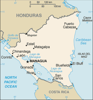
Nicaragua Google Maps
To activate Street View on any city of Nicaragua, drag above the Zoom feature the yellow little man in the map.
Facts about Nicaragua
| Administrative divisions: | 15 departments (departamentos , singular - departamento) and 2 autonomous regions* (regiones autonomistas , singular - region autonoma); Atlantico Norte* , Atlantico Sur* , Boaco , Carazo , Chinandega , Chontales , Esteli , Granada , Jinotega , Leon , Madriz , Managua , Masaya , Matagalpa , Nueva Segovia , Rio San Juan , Rivas |
| Area: | total: 129 ,494 sq km land: 120 ,254 sq km water: 9 ,240 sq km |
| Background: | The Pacific coast of Nicaragua was settled as a Spanish colony from Panama in the early 16th century. Independence from Spain was declared in 1821 and the country became an independent republic in 1838. Britain occupied the Caribbean Coast in the first half of the 19th century , but gradually ceded control of the region in subsequent decades. Violent opposition to governmental manipulation and corruption spread to all classes by 1978 and resulted in a short-lived civil war that brought the Marxist Sandinista guerrillas to power in 1979. Nicaraguan aid to leftist rebels in El Salvador caused the US to sponsor anti-Sandinista contra guerrillas through much of the 1980s. Free elections in 1990 , 1996 , and 2001 , saw the Sandinistas defeated , but voting in 2006 announced the return of former Sandinista President Daniel ORTEGA Saavedra. Nicaragua's infrastructure and economy - hard hit by the earlier civil war and by Hurricane Mitch in 1998 - are slowly being rebuilt. |
| Flag description: | three equal horizontal bands of blue (top) , white , and blue with the national coat of arms centered in the white band; the coat of arms features a triangle encircled by the words REPUBLICA DE NICARAGUA on the top and AMERICA CENTRAL on the bottom; similar to the flag of El Salvador , which features a round emblem encircled by the words REPUBLICA DE EL SALVADOR EN LA AMERICA CENTRAL centered in the white band; also similar to the flag of Honduras , which has five blue stars arranged in an X pattern centered in the white band |
| Capital: | name: Managua geographic coordinates: 12 09 N , 86 17 W time difference: UTC-6 (1 hour behind Washington , DC during Standard Time) |
| Climate: | tropical in lowlands , cooler in highlands |
| Currency code: | gold cordoba (NIO) |
| Ethnic groups: | mestizo (mixed Amerindian and white) 69% , white 17% , black 9% , Amerindian 5% |
| Geographic coordinates: | 13 00 N , 85 00 W |
| Geography note: | largest country in Central America; contains the largest freshwater body in Central America , Lago de Nicaragua |
| Government type: | republic |
| Imports partners: | US 20.9% , Mexico 15.2% , Costa Rica 7.6% , Guatemala 6% , China 5% , El Salvador 4.3% (2007) |
| Internet country code: | .ni |
| Land boundaries: | 910 km |
| Neighbouring countries: | total: 1 ,231 km border countries: Costa Rica 309 km , Honduras 922 km |
| Languages: | Spanish 97.5% (official) , Miskito 1.7% , other 0.8% (1995 census) note: English and indigenous languages on Atlantic coast |
| Location: | Central America , bordering both the Caribbean Sea and the North Pacific Ocean , between Costa Rica and Honduras |
| Map references: | Central America and the Caribbean |
| National holiday: | Independence Day , 15 September (1821) |
| Nationality: | noun: Nicaraguan(s) adjective: Nicaraguan |
| Natural hazards: | destructive earthquakes , volcanoes , landslides; extremely susceptible to hurricanes |
| Population: | 5 ,785 ,846 (July 2008 est.) |
| Religions: | Roman Catholic 58.5% , Evangelical 21.6% , Moravian 1.6% , Jehovah's Witness 0.9% , other 1.7% , none 15.7% (2005 census) |
| Terrain: | extensive Atlantic coastal plains rising to central interior mountains; narrow Pacific coastal plain interrupted by volcanoes |
| Unemployment rate: | 4.9% plus underemployment of 46.5% (2007 est.) |
Capital of Republic of Nicaragua
Managua (click to view Managua map)
Places in Nicaragua
Browse the most comprehensive and up-to-date online directory of administrative regions and Street Views in Nicaragua. Our listings are organized alphabetically, starting from level 1 regions and progressing through to level 2 and eventually level 3 regions, ensuring you can easily navigate and find specific areas of interest.
Carazo Department (129 google map locations)
Chinandega Department (213 google map locations)
Chontales Department (88 google map locations)
Estelí Department (52 google map locations)
Granada Department (118 google map locations)
Jinotega Department (93 google map locations)
Leon Department (278 google map locations)
Madriz Department (37 google map locations)
Masaya Department (64 google map locations)
Matagalpa Department (259 google map locations)
Nueva Segovia Department (58 google map locations)
Región Autónoma Atlántico Norte (192 google map locations)
Región Autónoma Atlántico Sur (144 google map locations)
Rio San Juan Department (20 google map locations)
Rivas Department (163 google map locations)
Random cities in Nicaragua
Managua, the capital city of Nicaragua.La Leonesa
El Encanto
San Francisco del Peñón
Catarina
Li-Dákura
Punta Ñata
Hato Nuevo
Tagua
El Carao
El Coyolar
Los Navarrete
El Rosario
Las Mercedes
La Fe
Casa Colorada
Las Tablas
Nindirí
Ciudad Darío
El Cantón
Link to Nicaragua Google Maps page
The map of Nicaragua has already attracted 3602 views. If you wish to embed our comprehensive Nicaragua map on your site, we offer an easy solution. This map includes free access to Google Maps, gazetteer search, detailed country and city maps, Street View, and essential facts, all ready to enhance your website. To use it, simply copy and paste the provided HTML code into your webpage's source code. We appreciate every link back to our Maps and Driving Directions. Thank you for your support!
| Text link to: Nicaragua map and facts page |
This Nicaragua map is intended solely for informational purposes. No representations or warranties are made concerning its accuracy or reliability. Users assume all risks associated with the use of Google Maps and Google Driving Directions. World Route Planner is not liable for any losses or delays that may occur from using this free Nicaragua map.